Category: 7-Day Outlook
 Highlights:
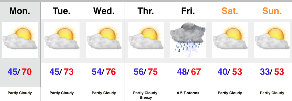
- Stretch of beautiful weather continues
- Breezy winds arrive Thursday
- Stormy end to the work week
- Cooler weekend
In the short term there’s no reason to waste a bunch of pixels on our forecast. High pressure will supply beautiful conditions and a building ridge will only promote warmer days ahead. Look for lots of sunshine and well above normal, near-record, warmth.
Southwest winds will become gusty Thursday and this is in advance of an approaching cold front that will deliver showers and thunderstorms Friday morning. The cold front will move through Friday afternoon and usher in much cooler air for the upcoming weekend.
Upcoming 7-Day Rainfall Forecast: 0.50″ – 1.00″
Permanent link to this article: https://indywx.com/were-getting-spoiled/
 Highlights:
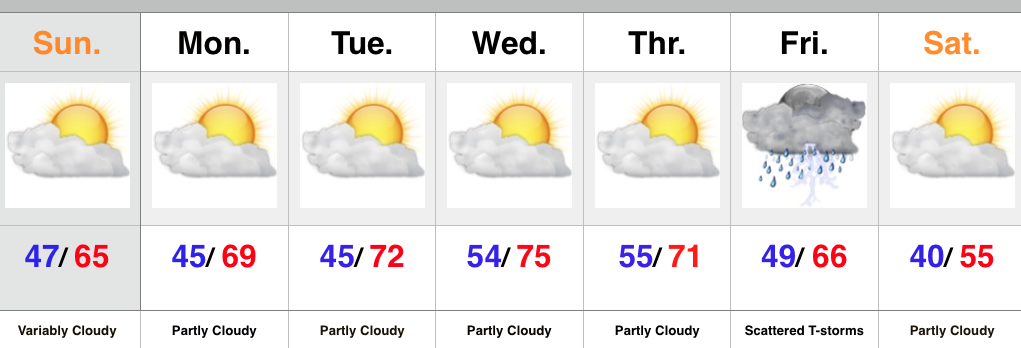
- Lots of sunshine to open November
- Unseasonably warm weather
- Late week storms with a cold front
We couldn’t ask for better weather to open November. Look for an extended stretch of unseasonably warm, tranquil conditions. It’ll be perfect to finish last minute yard clean up or get an early start on putting those Christmas decorations up. Enjoy!
The next weather system of note will arrive Friday in the form of a cold front. While timing issues are present, we’re keeping an eye on the possibility of scattered showers and thunderstorms (some strong). A drier and cooler air mass will build in next weekend. An early look at weather next Sunday would suggest frosty conditions for many…
Upcoming 7-Day Rainfall Forecast: 0.25″ – 0.50″
Permanent link to this article: https://indywx.com/beautiful-weather-2/
 Highlights:
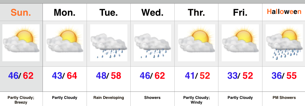
- Windy and showery Halloween
- Dry time returns with warmth
- Watching a more substantial storm at the end of the week
Good morning and happy Halloween, friends! We’re off to a cold and blustery start. Temperatures in the 40s, along with a stiff east breeze is presenting a chill in the air! A rather gloomy day is on deck with “showery” conditions at times, but there will be more dry time than not.
The second half of the weekend will turn brighter and very pleasant, and this will really set the tone for what will be a very tranquil first few days of November (where is time going)?! Unseasonably warm conditions will be with us for the balance of the upcoming work week and provide a great opportunity to get those yard chores taken care of or Christmas lights put up.
A more substantial storm system will arrive late week with showers and thunderstorms followed by colder air next weekend…
Upcoming 7-Day Rainfall Forecast: 0.50″ – 1″
Permanent link to this article: https://indywx.com/unseasonably-warm-open-to-november/
 Highlights:
- Increasing winds
- Turning much cooler
- Showers possible for Trick-Or-Treat
Low pressure is tracking into the Great Lakes this morning and the steady rain is ending from west to east. Showers will remain in our forecast today until a cold front sweeps the region later this evening, but the all day, steady rains are coming to an end. The other big story today will be strengthening northwest winds late. Those northwest winds (gusts of 30-40 MPH) will help drive much cooler air southbound to wrap up the work week!
Our next weather maker will, unfortunately, arrive over the weekend and we must maintain shower chances during the all important Saturday evening Trick-Or-Treat forecast. While heavy rain isn’t anticipated, it could be just enough to require rain gear when you’re out and about.
Ridging will develop over the eastern US early next week and be responsible for a nice stretch of “Indian Summer” weather.
Upcoming 7-Day Rainfall Forecast: 0.25″ – 0.50″
Permanent link to this article: https://indywx.com/turning-windy-and-cooler/
 Highlights:
- Cooler and breezy
- Soaking rain builds in Tuesday
- Watching Halloween
A cold front moved through the area Saturday afternoon and evening and high pressure is now in control with dry skies, cooler temperatures, and breezy conditions. All in all, a beautiful autumn day is on tap! Enjoy!
Remnant moisture of Patricia will track north and team up with a cold front in the Tuesday-Wednesday time period. Embedded thunderstorms and locally heavy rain can be expected. This, of course, is much needed after what’s been a dry time of things the past couple months.
The cold front will sweep through the area Wednesday night and put an end to the rain. Strong northwest winds will usher in a much cooler air mass to wrap up the work week.
We’ll continue monitoring the goings on for Halloween. Models have varied from run to run over the past few days and timing issues will likely continue.
Upcoming 7-Day Rainfall Forecast: 1.25″ – 1.75″
Permanent link to this article: https://indywx.com/feeling-more-like-fall-rain-builds-in-tuesday/
