Category: 7-Day Outlook

Very Windy Today; Next Big Storm Next Week…

Screen Shot 2015-11-12 at 7.17.23 AMHighlights:

  • Very strong winds
  • Dry times return
  • Big storm next week

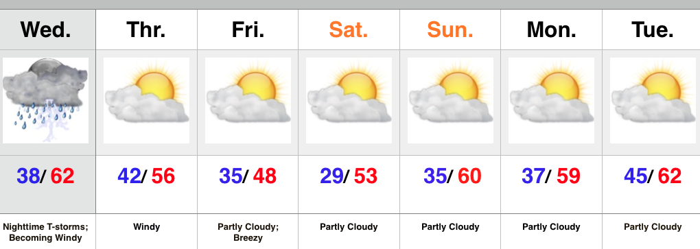
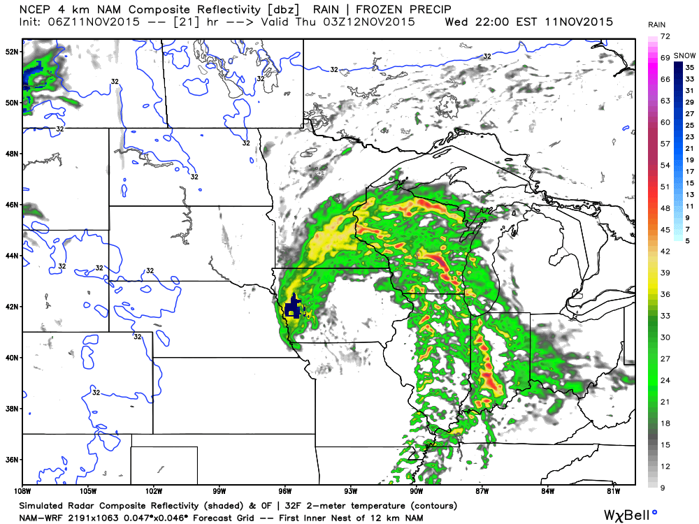
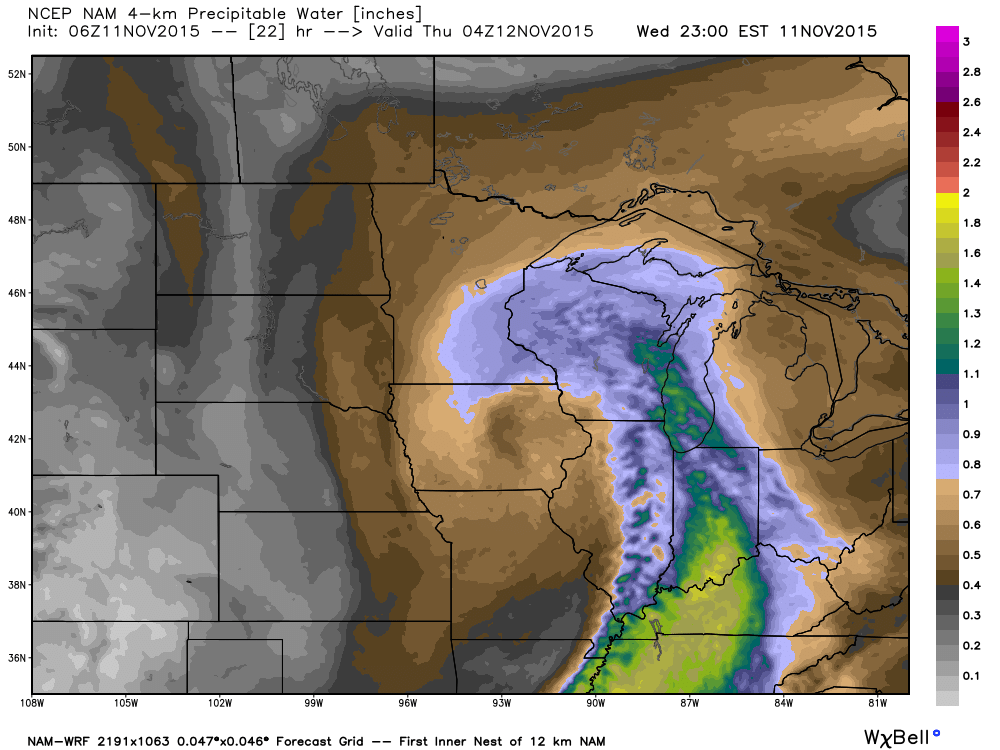
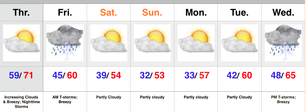
A cold front swept through the state during the predawn hours.  While a few breaks of sunshine may be seen early this morning, low clouds will quickly spread back over the region.

Wind will be the big story today as we still think gusts over 50 MPH are a good bet throughout central parts of the state.  Note the tight pressure gradient that remains in place across the region today into Friday.  Friday won’t be AS windy as today, but still quite blustery.

gfs_ptype_slp_conus2_3

gfs_ptype_slp_conus2_7
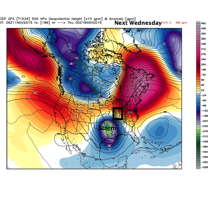
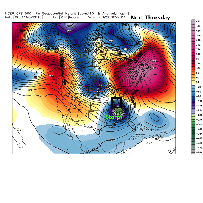
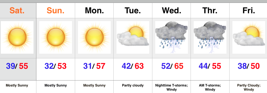
Our next big weather maker will arrive during the early to middle portions of next week.  Model consensus continues to highlight a hefty rain event and thunderstorms.  Early numbers would suggest 2″-3″ potential.  More details on our next storm tomorrow and on Twitter (@IndyWx).

Before we close this morning, we wanted to post the updated JAMSTEC seasonal outlook for the upcoming winter.  As a whole there aren’t a lot of changes from previous runs.  (We like to see consistency :-)).

JAMSST

JAMTemp

JAMPrecipOverall, it agrees with our forecast and strongly disagrees with any of those warm winter forecasts out there for the south and east.  One note, just because the drier anomalies show up over the Ohio Valley (what you would typically expect during a moderate to strong El Nino event) doesn’t necessarily mean it’ll be a lower than normal snow season.  Keep in mind, moisture content in snow is much less than rain.

After taking a look at things, I like where we stand with our Winter Outlook.  One thing’s for sure, time will tell!

Permanent link to this article: https://indywx.com/very-windy-today-next-big-storm-next-week/

Big Time Wind Event; Active Pattern…

Screen Shot 2015-11-11 at 7.17.55 AMHighlights:

  • Nighttime storms
  • Prolonged wind event
  • Eyeing our next storm

The morning has dawned with mid and high level clouds painting the back drop as the sun rises.  We’ve shared several photos on our Twitter page (@IndyWx) of the beautiful sun rise.  Thank you and keep ’em coming!

Low pressure is moving off the Rockies this morning (where another hefty snow dump took place overnight) and into the Plains.  The low will then track into the Great Lakes Thursday.  As the low moves northeast, it’ll swing a cold front through our neck of the woods Thursday morning.  We still bracket tonight into the wee morning hours Thursday for thunderstorm potential.  See the simulated radar valid at 10p this evening, courtesy of Weatherbell.com.

10pWed

CAPE (Convective Available Potential Energy) is lacking with this storm and moisture return isn’t impressive.  This is good news as it will reduce the amount of severe weather we’ll see.  However, it should be noted that it won’t take much to bring down a severe wind report or two and that is our primary concern tonight with any storm.

CAPE- courtesy of Weatherbell.com

CAPE- courtesy of Weatherbell.com

Surface Dew Points- courtesy of Weatherbell.com

Surface Dew Points- courtesy of Weatherbell.com

Precipitable Water- courtesy of Weatherbell.com

Precipitable Water- courtesy of Weatherbell.com

Because of the lack of moisture return and the overall speed of the system, rainfall tonight won’t be impressive for most (0.25″-0.50″ on average) with the exception of localized stronger storms.

What will be impressive is the wind, even without storms.  A Wind Advisory has been issued for late tonight and Thursday, via the National Weather Service out of Indianapolis, and rightfully so.  We wouldn’t be surprised if a portion of this is upgraded to a High Wind Warning later today or tonight as gusts of 50 MPH+ will be a concern through the day Thursday as our low occludes over the Lakes.

A period of drier air will return to wrap up the week and head into early next week, but we eye another big storm system for the middle of next week.  Forecast models differ on precise details, as you’d expect at this juncture.

WedStormTrack

ThrStormTrack

The GFS (above) isn’t shying away from another significant impact event.  The European isn’t as bullish early on.  All mid range models do produce moderate to heavy rains over the region.  Stay tuned as we continue to monitor.

Permanent link to this article: https://indywx.com/big-time-wind-event-active-pattern/

Still Eyeing Mid Week Storms; Windy And Colder To Close The Week…

Screen Shot 2015-11-10 at 7.07.33 AMHighlights:

  • Wednesday night storms
  • Very windy to close the week
  • Colder Friday

The overall set-up over the next couple days will feature a strong autumn storm coming off the Rockies (today), crossing the Plains (Wednesday), and heading northeast into the Great Lakes to offer up some “fresh water fury!” (Thursday).

Here’s the track of our storm, courtesy of Weatherbell.com.

TueEvening

WedEvening

ThrEveningWe still need to monitor things closely for the potential of severe weather Wednesday evening, but latest data would suggest a lower chance of severe, overall.  Certainly not worth letting your guard down, but the lack of moisture return and timing are both on our sides in this particular event.  Localized damaging straight line winds are still of greatest concern of any of the severe elements across central IN and this would be for Wednesday night.

Here’s a look at the latest simulated radar for 10p Wednesday.  As we always say, don’t pay particularly close attention to the precise time.  This should be used as guidance as what the radar may look like Wednesday evening.

10pradarWedAs mentioned above, the speed, timing, and lack of moisture return strongly argue against significant rainfall with this storm.  We’ll forecast around 0.25″ with locally heavier totals in storms.  Not a big deal from a precipitation perspective.

What is a big deal is the wind on the backside of the low as northwest gusts really crank in the Thursday-Friday time frame (30-40 MPH).  Needless to say, Thursday isn’t a day to wear a hat. 🙂

Longer term, data continues to argue against any sort of sustained chill through the rest of November.  We note the SOI is actually positive right now.  This is certainly unusual with the ongoing El Nino and well above the base state (a warm sign).

Screen Shot 2015-11-10 at 6.55.51 AM


The MJO is also projected to rumble through the warm Phases of 2 and 3 over the next few weeks.  Note these are overall warmer than normal phases in November.

Screen Shot 2015-11-10 at 6.59.42 AM


Screen Shot 2015-11-10 at 6.57.56 AM

Permanent link to this article: https://indywx.com/still-eyeing-mid-week-storms-windy-and-colder-to-close-the-week/

Dry, Chilly November Weekend; Mid Week Storms…

Screen Shot 2015-11-07 at 10.56.54 AMHighlights:

  • Sunny and cool
  • Midweek Storms
  • Prolonged period of windy weather late week

High pressure is building into the Ohio Valley this weekend and helping supply sunshine and that cool, crisp air we enjoy this time of year.  Freeze and frost conditions are ahead tonight and again Monday morning as high pressure moves overhead and results in clear skies and calm winds.

As the high moves to our east, a return SW flow will help moderate temperatures for mid week. As our next storm system comes out of the Plains it’ll intensify as it tracks into the Great Lakes.  Thunderstorms will accompany the cold front as it swings through the state Wednesday night.  We’ll monitor for strong to severe storm potential.  A lot will hinge upon the precise track of the surface low and we’ll keep a close eye on things over the next couple days.  We’ll turn cooler again late next week with strong winds shifting from the SW to NW.

Upcoming 7-Day Rainfall Forecast: 0.50″

Permanent link to this article: https://indywx.com/dry-chilly-november-weekend-mid-week-storms/

Gusty Storms Followed By November Chill…

Screen Shot 2015-11-04 at 9.55.56 PMHighlights:

  • One more warm day
  • Gusty storms late tonight-Friday morning
  • Feeling more seasonal this weekend
  • Next storm arrives at the end of the period

High pressure will give way to an approaching cold front tonight.  Variably cloudy skies this morning will turn increasingly cloudy as the afternoon/ evening progresses.  Gusty SW winds will increase and gust over 20 MPH by afternoon.

The cold front will move through central IN early Friday morning and be preceded by a line of showers and embedded thunderstorms.  A few of these storms may contain strong winds, and this potential is something we’ll continue to keep a close eye on through the day Thursday.  Beneficial rains will also accompany the frontal passage.

The big story going into the weekend will be a much cooler, more seasonable feel, but sunshine will also be in our forecast.

Our next storm system of note appears to have eyes on the region by the middle of next week.

Upcoming 7-Day Rainfall Forecast: 0.5″ – 1″

Permanent link to this article: https://indywx.com/gusty-storms-followed-by-november-chill/