Category: 7-Day Outlook

Unseasonably Chilly, Active Pattern…

Screen Shot 2016-04-02 at 9.39.00 AMHighlights:

  • Busy, active pattern
  • Unseasonably cool
  • Multiple hard freezes ahead

Fast-Moving Weather Pattern…The upcoming forecast period will feature multiple fast-moving weather systems in an almost every other day format.  It’s an unseasonably chilly pattern, as whole, as well.

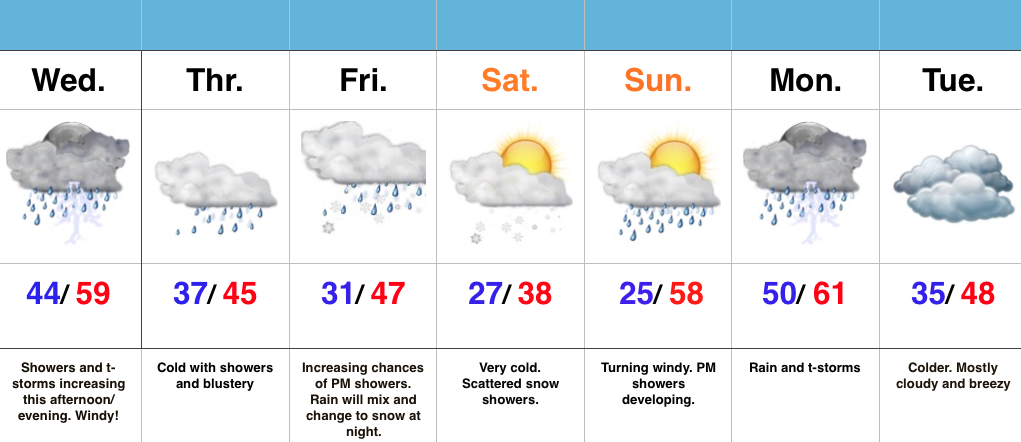
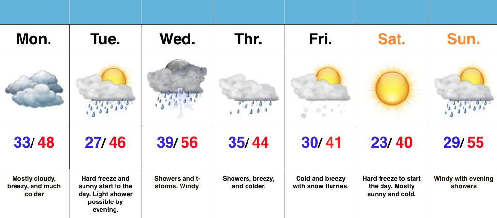
Saturday has opened with plentiful sunshine, but clouds will quickly increase and winds will turn strong (50+ MPH gusts) as we progress into the afternoon.  Batten down the hatches.  A few showers will accompany those clouds and some small hail is also possible with a few “stronger” showers.  As colder air pours in this evening, widely scattered snow showers will impact north-central IN.

A hard freeze will take place tonight into Sunday morning.  High pressure will briefly supply a mostly sunny day Sunday, but our next system will approach late Sunday night.  Consequently, SW winds will turn strong and gusty late Sunday and a broken band of showers will be associated with reinforcing chilly air late Sunday night into the pre dawn hours Monday.

A more significant storm system will arrive on the scenes mid week and feature more widespread rains Wednesday (perhaps an embedded thunderstorm, as well).  As a cold front slides through here Thursday, MUCH colder air will push into central IN and transition lingering left over moisture into scattered snow showers/ flurries late Thursday night into early Friday morning.  Friday certainly won’t feel much like April around these parts…

Permanent link to this article: https://indywx.com/unseasonably-chilly-active-pattern/

Saturday Morning Video Update…

We open the forecast period dry and pleasant, but we turn stormy late Easter Sunday and MUCH colder air still looks to arrive as we welcome April.  Details can be…

You must be logged in to view this content. Click Here to become a member of IndyWX.com for full access.  Already a member of IndyWx.com All-Access?  Log-in here.

Permanent link to this article: https://indywx.com/saturday-morning-video-update-4/

Wet Day On Tap…

Screen Shot 2016-03-24 at 9.00.42 AMHighlights:

  • Showers and t-storms
  • Chilly Good Friday
  • Tricky Easter Forecast

Showers And Embedded Thunder Today…Showers and thunderstorms will be with us for the majority of the late morning and afternoon hours before a cold front sweeps through the state tonight and sets up a dry, but much colder time of things for Good Friday.  Locally heavy downpours are a good bet today, including some 1″+ totals across central parts of the state.

The first half of the Easter weekend is looking very nice.  Certainly of the two days, we’d recommend getting that Easter Egg Hunt in on Saturday as clouds will increase Easter Sunday and give way to late day rain.  Modeling isn’t in agreement on the timing of rain Easter, but we’re siding more with the GFS approach for now (earlier arrival when compared to the European).  Stay tuned as we fine tune ;-).

Our “topsy turvy” weather pattern will continue into next week, but we still eye a significant cold front and associated MUCH colder air mass during the first (10) days of April…

Permanent link to this article: https://indywx.com/wet-day-on-tap/

The “Ups And Downs” Of Spring…

Screen Shot 2016-03-21 at 9.17.30 AMHighlights:

  • Dry, chilly open to the week
  • Unsettled mid week
  • Watching Easter

Ice Scrapers Needed This Morning…Many Indiana neighborhoods awoke to temperatures in the 20s this morning.  Thankfully, that late March sun angle will help boost temperatures quickly today to around 50 for afternoon highs.

A warm front will lift through the region Tuesday and could spark a shower or two, but most will remain dry.  We’ll turn briefly milder Tuesday and Wednesday before better coverage of showers and embedded thunder arrive on scene Thursday.  This is in association with a cold front that will deliver a quick pop of colder air to close the week, including Good Friday.  There’s the chance enough cold air could catch lingering moisture to allow for a few snow showers late Thursday night before we dry things out completely.

As we look ahead to Easter, another storm system will arrive quickly.  As such, we’re forced to increase rain chances (and coverage) Easter Sunday.

Longer term, indications continue to point towards a rather rude open to April, including well below normal temperatures.

Permanent link to this article: https://indywx.com/the-ups-and-downs-of-spring/

Sunday Weather Rambles…

1.) Indianapolis is running much warmer (+9.1°) and slightly drier than normal (-0.15″) month-to-date.      2.) Snow is flying to our southwest, and accumulating for some in and around St.…

You must be logged in to view this content. Click Here to become a member of IndyWX.com for full access.  Already a member of IndyWx.com All-Access?  Log-in here.

Permanent link to this article: https://indywx.com/sunday-weather-rambles/