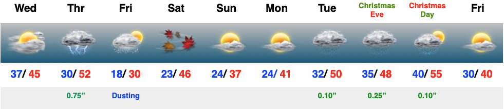
Category: 10-day

Protected: Long Range Client Discussion: Winter Isn’t Finished

This content is password protected. To view it please enter your password below: Password:

You must be logged in to view this content. Click Here to become a member of IndyWX.com for full access.  Already a member of IndyWx.com All-Access?  Log-in here.

Permanent link to this article: https://indywx.com/2016/03/10/long-range-client-discussion-winter-isnt-finished/

Protected: Long Range Client Discussion And Video Update…

This content is password protected. To view it please enter your password below: Password:

You must be logged in to view this content. Click Here to become a member of IndyWX.com for full access.  Already a member of IndyWx.com All-Access?  Log-in here.

Permanent link to this article: https://indywx.com/2016/03/09/long-range-client-discussion-and-video-update-2/

Protected: Long Range Client Discussion And Video Update…

This content is password protected. To view it please enter your password below: Password:

You must be logged in to view this content. Click Here to become a member of IndyWX.com for full access.  Already a member of IndyWx.com All-Access?  Log-in here.

Permanent link to this article: https://indywx.com/2016/03/08/long-range-client-discussion-and-video-update/

Protected: Long Range Client Video Discussion…

This content is password protected. To view it please enter your password below: Password:

You must be logged in to view this content. Click Here to become a member of IndyWX.com for full access.  Already a member of IndyWx.com All-Access?  Log-in here.

Permanent link to this article: https://indywx.com/2016/03/07/long-range-client-video-discussion-2/

Protected: Client Video Discussion On The Heavy Rain Situation…

This content is password protected. To view it please enter your password below: Password:

You must be logged in to view this content. Click Here to become a member of IndyWX.com for full access.  Already a member of IndyWx.com All-Access?  Log-in here.

Permanent link to this article: https://indywx.com/2016/03/04/client-video-discussion-on-the-heavy-rain-situation/

Protected: Premium Long Range Video Discussion…

This content is password protected. To view it please enter your password below: Password:

You must be logged in to view this content. Click Here to become a member of IndyWX.com for full access.  Already a member of IndyWx.com All-Access?  Log-in here.

Permanent link to this article: https://indywx.com/2016/02/27/premium-long-range-video-discussion/

Protected: Client Long Range Video…

This content is password protected. To view it please enter your password below: Password:

You must be logged in to view this content. Click Here to become a member of IndyWX.com for full access.  Already a member of IndyWx.com All-Access?  Log-in here.

Permanent link to this article: https://indywx.com/2016/02/26/client-long-range-video/

Thursday Evening Rambles…

1.) 10-day Client discussions (Pro and Premium) and our March Outlook (Premium) has been sent to your inbox. 2.)  A windy warm-up is still on track as we wrap up…

You must be logged in to view this content. Click Here to become a member of IndyWX.com for full access.  Already a member of IndyWx.com All-Access?  Log-in here.

Permanent link to this article: https://indywx.com/2016/02/18/thursday-evening-rambles/

10-Day AG-Weather Outlook…

10 Day AG-Weather Outlook

Issued: 02.07.16

Forecast period: 02.07.16 – 02.17.16

Focal Items:

  • Busy winter pattern from the Plains east
  • Dry and warm across the West
  • Potential widespread winter storm threat days 7-10 from the Plains into the East

Summary: Changes are underway at the beginning of the period with a positive PNA pattern in place.  This will support a drier and warmer than normal time of things across the west with a shift towards much colder than normal temperatures across the eastern half of the country.  Early in the period, we’re tracking a coastal storm that will deliver blizzard conditions to the Cape Monday and a big upper low over the Great Lakes and Ohio Valley.  This will provide a prolonged snow shower event across the areas mentioned above.  Toward the end of the period, we’ll have to remain focused over the southern/ central Plains for the potential of a developing winter storm that would then advance into the Ohio Valley and eventually Mid Atlantic.

Sensible Impacts: Strong ridging across the West will keep things drier and warmer than normal, with the action across the eastern half of the nation.

In addition to snow, wind, and near blizzard conditions that will impact the Cape to open the work week, blizzard conditions will also impact the northern Plains as an upper trough drops south.  The same trough and associated upper level energy will deliver snow showers and embedded blinding snow squalls south into the Ohio Valley and southern Appalachians through mid week, as well.

A very active northwest flow will send light to moderate snow makers southeast out of the N. Plains into the Ohio Valley through the upcoming work week.  Overall, most snowfall accumulations will remain light, with the exception of Snow Belt areas.

A significant winter storm appears to be brewing next weekend and could impact a large portion of the Plains, Ohio Valley, and Mid Atlantic towards the end of the period.

Temperature Anomalies: A very cold time of things is ahead for the forecast region through the period.  In some cases, temperatures will fall to levels some 15-20 degrees below normal.

Tuesday

Temperature anomalies Tuesday. Source: Tropicaltidbits.com

Temperature anomalies Wednesday. Source: Tropicaltidbits.com

Temperature anomalies Wednesday. Source: Tropicaltidbits.com

Temperature anomalies next weekend. Source: Tropicaltidbits.com

Temperature anomalies next weekend. Source: Tropicaltidbits.com

Precipitation: Snowfall will generally be light through the forecast region this week. Despite the light snowfall, very strong winds will likely lead to blizzard conditions in the open country, particularly across IA and MN early in the period. Heavier snow will be possible as the potential winter storm develops next weekend across the central Plains.

Permanent link to this article: https://indywx.com/2016/02/07/10-day-ag-weather-outlook-2/

10 Day Ag-Weather Outlook…

10 Day AG-Weather Outlook

Issued: 01.31.16

Forecast period: 02.01.16 – 02.10.16

Focal Items:

  • Plains blizzard Days 1-3
  • Severe threat from the Mid South to the Ohio Valley Tuesday
  • Impactful winter event developing late in the period

Summary:  The forecast period will begin with strong ridging across the eastern half of the CONUS, while a significant trough digs across the west. That trough will lift northeast through the middle of the upcoming work week before re-amplifying over the upcoming weekend into early week 2 across the Plains and Ohio Valley region.

Sensible Impacts:  A significant storm system will move off the Rockies and into the Plains Monday.  The surface low  will track northeast from SE CO Monday night into SW MI Tuesday night.  To the north and northwest of the surface low, heavy snow and blizzard conditions will impact areas from CO, KS, NE, IA, MN, and WI.  South and southeast of the surface low track, strong to severe thunderstorms will rumble through the lower MS Valley, TN Valley, and Ohio Valley Monday night into Tuesday night.  All modes of severe weather will be possible, including tornadoes.

We’ll need to keep a close eye on the potential of a clipper system diving SE across the N. Plains and upper Ohio Valley over the upcoming weekend, but the bigger event appears to be a developing winter storm threat centered on the end of the period (2/8-2/10 time period).  There are, obviously, a lot of details to sort through, but an impactful winter event is very possible across the Ohio Valley towards the end of the forecast period.

Temperature Anomalies:  The period will open much warmer than normal, but transition cold, and eventually colder than normal by the end of the period across the forecast region.

Screen Shot 2016-01-31 at 5.25.30 PM

Anomalous warmth will engulf the Ohio Valley to open the forecast period. Source: Penn State E-Wall

The pattern shifts colder than normal towards the end of the period across the Plains into the southeast. Source: Penn State E-Wall

The pattern shifts colder than normal towards the end of the period across the Plains into the southeast. Source: Penn State E-Wall

Precipitation:  A stripe of heavy snows (10″-15″) will fall from CO, NE, IA, southern MN, and WI with the initial early week storm.  .5″-1.5″ of rain will fall across the Southeast, TN, and OH Valley regions (locally heavier totals where strong storm train).  Overall, quieter times return mid and late week for the forecast region before the next potential strong storm develops late in the period.

For private weather consulting and more detailed ag-weather updates, please e-mail bill@indywx.com.

Permanent link to this article: https://indywx.com/2016/01/31/10-day-ag-weather-outlook/

IndyWx.com