Category: 10-day

Just A Little Busy In The Forecast Office…

Updated 02.22.24 @ 7:20a

“Busy” is one way to describe the upcoming week to 10 days worth of weather as the pattern around these parts, and a large chunk of the East, takes on a spring look and feel. Everything from thunderstorms, rain, clipper snow, and an opportunity for strong to severe storms is included in the week ahead.

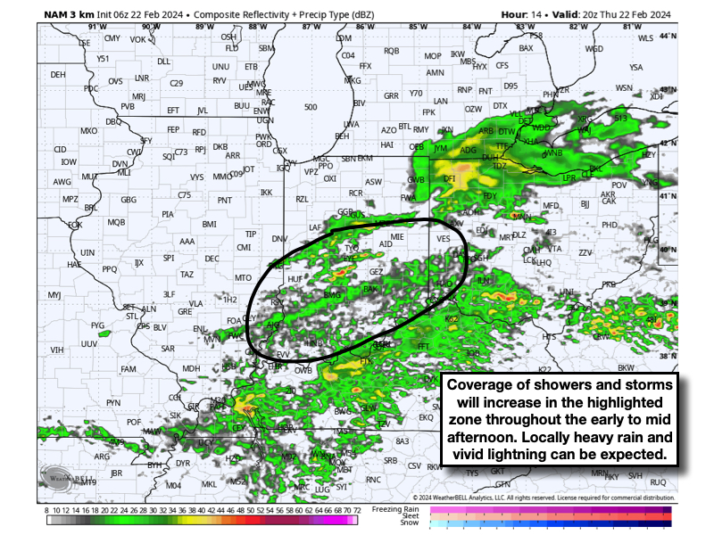
An area of low pressure will move through central and southern Indiana this afternoon, continuing to present scattered to numerous showers and thunderstorms across the area. While north-central Indiana has been the focal zone for early morning activity, we anticipate more of central and southern Indiana will be impacted throughout the afternoon and early evening.

All of this precipitation and embedded thunder will push off to the south of the area around or just after dinnertime. A quiet night is on deck with cooler air flowing back into the state. This will lead to a calm close to the work week as temperatures “warm” back to around 50° Friday afternoon as sunshine returns.

As we open the weekend, a rapidly moving clipper system will drop southeast across the region, eventually leading to several inches of wet snow for the east TN and western NC mountains. Back here on the home front, a period of snow is expected to develop late Friday night and predawn Saturday. While this certainly won’t be anything like what we saw last Friday, a wet coating of snow is possible in spots as this upper air feature dives across the region. By daybreak Saturday, all of the snow will be out of the area and we’ll be talking about working in more in the way of sunshine into the mix as our day progresses. Gusty northerly winds Saturday morning will diminish as the day wears on.

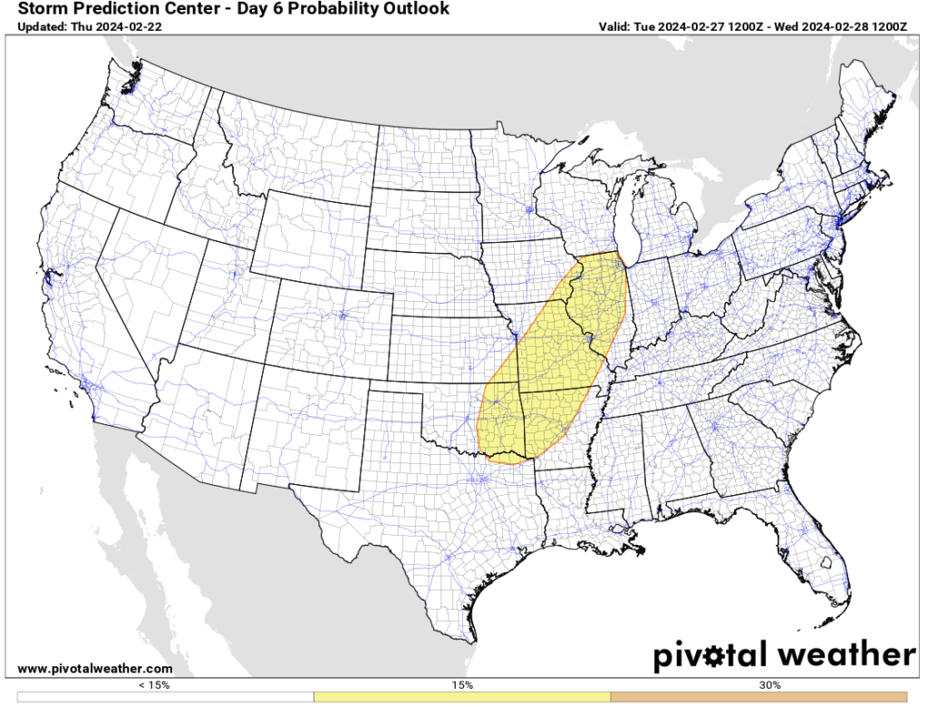
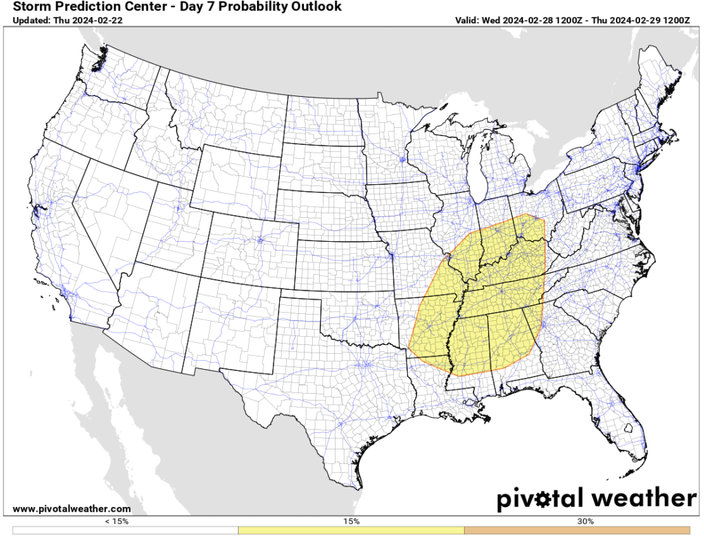
A quick warm-up is on the way for the 2nd half of the weekend. In fact, highs will approach 60° Sunday afternoon (how’s that for weather whip-lash?!). These warmer times will allow a more potent round of storm to rumble across the region as we progress through the early stages of next week. A warm front will lift northeast across the region Monday with showers and then attention turns to the threat of strong to severe thunderstorm potential as we go through our Tuesday and Wednesday. More on the specific timing and severe threats (damaging straight line wind appears to be the biggest concern from this distance) with updates to come in the days ahead.

The Storm Prediction Center (SPC) is already highlighting the region for the opportunity of severe weather Tuesday and Wednesday.

Tuesday (2/27) Severe Weather Outlook: Source SPC
Wednesday (2/28) Severe Weather Outlook: Source SPC

Permanent link to this article: https://indywx.com/just-a-little-busy-in-the-forecast-office/

VIDEO: Tuesday Clipper Followed By An Extended Stretch Of Quiet Conditions…

Updated 01.29.24 @ 5:59a We’ll close January and open February with an extended stretch of unseasonably quiet (and mild) conditions. The only exception? A weak clipper that will offer up…

You must be logged in to view this content. Click Here to become a member of IndyWX.com for full access.  Already a member of IndyWx.com All-Access?  Log-in here.

Permanent link to this article: https://indywx.com/video-tuesday-clipper-followed-by-an-extended-stretch-of-quiet-conditions/

VIDEO: Short And Long Term Ideas- Any Thoughts Of Winter’s Demise Premature In Our Opinion…

Updated 01.22.24 @ 6:23p

You must be logged in to view this content. Click Here to become a member of IndyWX.com for full access.  Already a member of IndyWx.com All-Access?  Log-in here.

Permanent link to this article: https://indywx.com/video-short-and-long-term-ideas-any-thoughts-of-winters-demise-premature-in-our-opinion/

Prolonged Period Of Bitterness, But A Change Is On The Horizon…

Updated 01.12.24 @ 12:18p

The upcoming 10-days is a case of cold and if you believe some of the guidance, even colder (next weekend). Multiple nights below zero and dangerous wind chill values of 20° to 30° below zero are on tap at times during this period. You know that we’re interested to see if we meet our respective targets. It’s not just the magnitude of the cold, but the duration and widespread nature, as shown over the upcoming 10-day temperature anomalies from last night’s European ensemble.

But milder changes are on the horizon as we rumble through the warmer phases (at least this time of year) of the MJO and see some temporary trends within our teleconnection suite (AO, NAO, EPO, and PNA) that favor a period of much less harsh, and even milder than normal conditions developing by the last week of the month.

After our frigid stretch, temperatures even only a few degrees above normal will feel like a heatwave.

The hunch here is that we return to another cold stretch as we rumble into February. Long range guidance shows “part 2” of our high latitude blocking event and the thought here is this is a byproduct of a combination of sea surface temperature (SST) configuration in the northwest ATL, the current state of our Nino, as well as the SST configuration in the central/ northern PAC. At any rate, the alignment between teleconnections and, of course, the MJO rolling into the colder phases supports this idea. Let us worry about that and you enjoy the late month “mild-up!” Heavens knows after these next couple weeks, you will have earned it!

We’ll continue to keep tabs on the threat of snow over the next couple weeks. Things can, obviously, change but as of now I’m not seeing any hefty snow threats for central Indiana. The one feature that does potentially require watching is out there towards the end of next week, but the overall fast paced flow should prevent this from deepening into anything overly significant. At least that’s the way we see it now.

We’ll continue to keep close tabs on short-term trends but feel good with what we have out there concerning rain/ snow amounts, timing of the transition, and damaging wind potential.

Permanent link to this article: https://indywx.com/prolonged-period-of-bitterness-but-a-change-is-on-the-horizon/

VIDEO: Multiple Impactful Storms Into Mid Month; Discussing Overnight Ensemble Trends…

Updated 01.04.24 @ 6:46a Enjoy the last couple of quiet days while you have them. Skies will slowly brighten later today, but otherwise anticipate mostly cloudy and seasonably cold conditions.…

You must be logged in to view this content. Click Here to become a member of IndyWX.com for full access.  Already a member of IndyWx.com All-Access?  Log-in here.

Permanent link to this article: https://indywx.com/video-multiple-impactful-storms-into-mid-month-discussing-overnight-ensemble-trends/