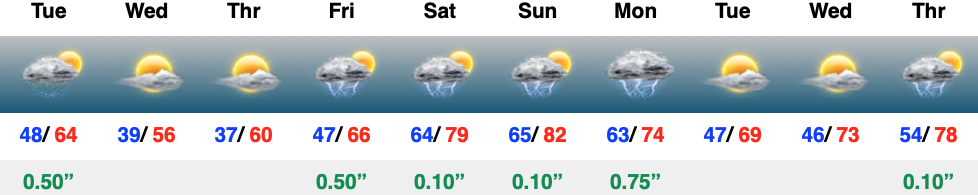
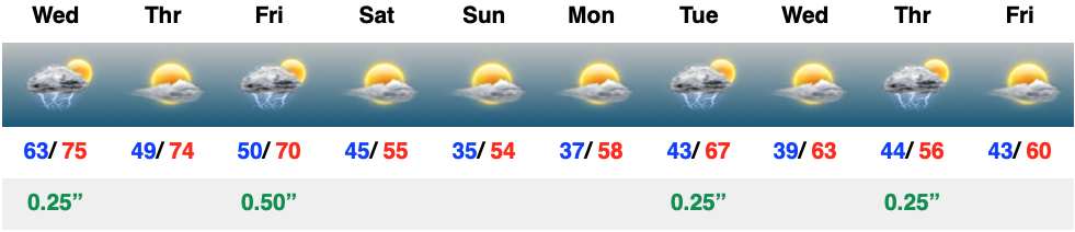
Low level clouds will continue to push south this morning, leading to a mostly cloudy day, especially along and north of the I-70 corridor. Downstate will hold on to sunshine a little longer than up this way. All in all, it’ll be a cool and breezy day. Those clouds will clear out of here quickly later today and as winds diminish, it’ll set the stage for frost in many areas, especially outside of the city, itself come Thursday morning. Hang in there, warmer (and increasingly muggy days) await as we push through the weekend. This sets the tone for what’s ahead as we flip the page to early May…
The day is dawning quiet but that will change as we move through the afternoon. Not only will rain increase in coverage and intensity, but winds will pick up out of the southwest. A wind-whipped rain will greet commuters on the way home this evening.
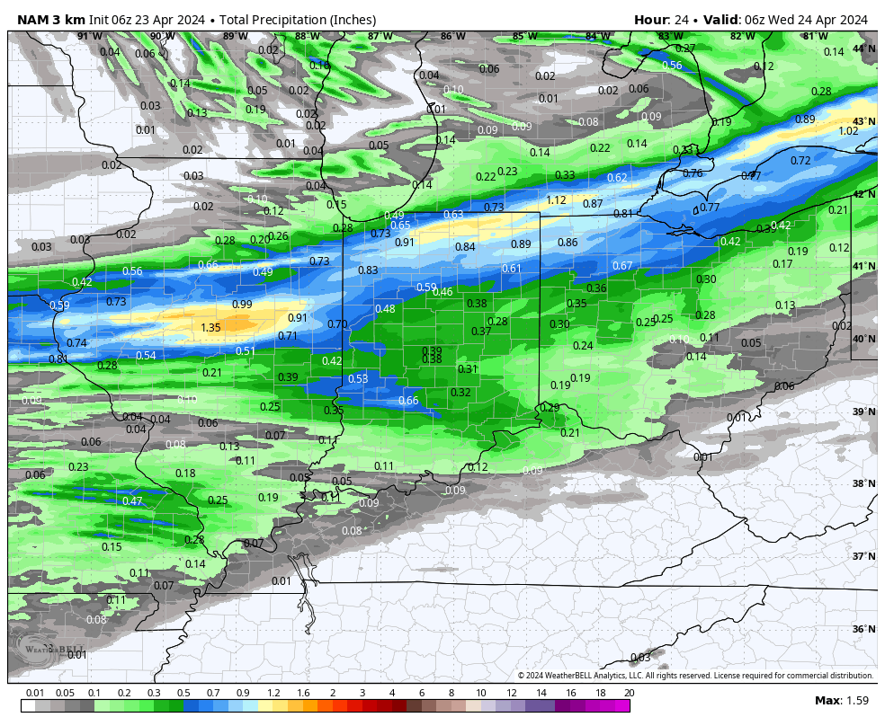
Rain will overspread central IN later this afternoon into the evening.
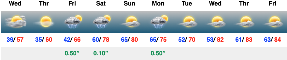
Most local rain gauges should accumulate 0.35″ to 0.50″ with the passage of this cold front.
As mentioned, winds will be strong and gusty today. We’ll top out with gusts upwards of 40 MPH across the region- perhaps even a bit stronger in spots.
High pressure will settle overhead midweek, allowing for clearing skies, diminishing wind, and cooler temperatures.
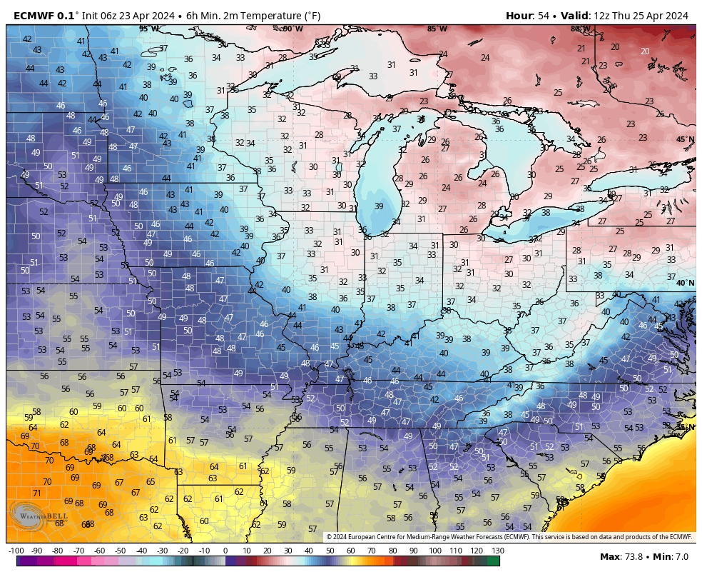
Additional chances of patchy frost can be expected around the greater Indy area by Thursday morning. Outlying areas away from the city, itself, can expect to dip into the lower to middle 30s Thursday morning with widespread frost.
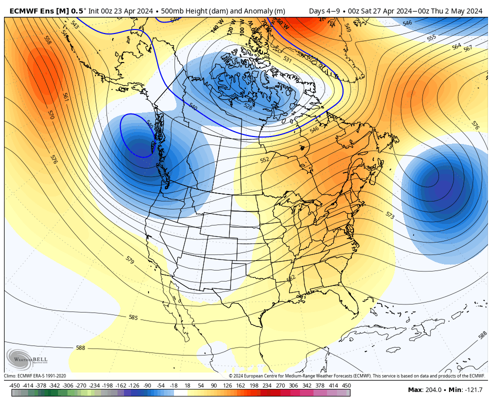
As we look ahead to the weekend and early next week, our region will undergo a regime change. Warmer, increasingly muggy air will replace the cool, stable air of midweek and storm chances will also increase. As of now, it looks like wettest days, including most widespread storms, will come Friday and Monday. While you’ll note storms in the forecast “box” below for Saturday and Sunday, it’s important to reiterate these will likely be few and far between (“splash and dash” variety). Most of the weekend is looking dry as of now.
It was a frosty start to the morning across central Indiana, especially in outlying areas. We’ll do it all over again tonight and Monday morning as temperatures dip back into the lower and middle 30s. The fine folks over at the Indianapolis National Weather Service office have hoisted a Frost Advisory from 1a to 10a Monday.
Widespread frost is expected Monday morning.
Otherwise, the work week will open with a continuation of the sunny skies we’ve enjoyed over the past few days.
That will all begin to change as a cold front arrives from the northwest on Tuesday. Clouds will quickly return and showers and thunderstorms will follow. We’re not talking about excessive rainfall with this system, but 0.25″ to 0.50″ is likely as the front moves through the Ohio Valley. Gusty southwesterly winds can also be expected, including up to 40 MPH at times Tuesday.
Rain and embedded thunder returns Tuesday.
This will be a fast moving system and dry conditions will quickly return overnight and into Wednesday morning. This FROPA we’ll also help to reinforce the chilly airmass and a renewed frost (and potentially even a freeze) threat looms by Wednesday and Thursday mornings.
Another round of frost is expected midweek.
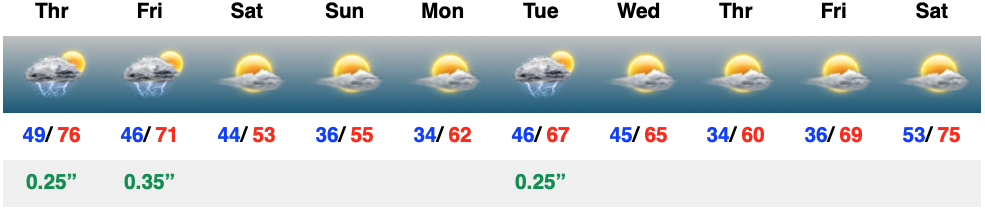
As we roll into next weekend, an overall regime change is on the docket, including a much warmer and more humid airmass engulfing the region. Along with this transition to more of a tropical feel, heavier rain and storms will return as well. As of now, closing out April and opening May is looking to feature numerous heavier rain and storm events. This will all get kicked off Friday.
A return of active times is expected to close April and open May.
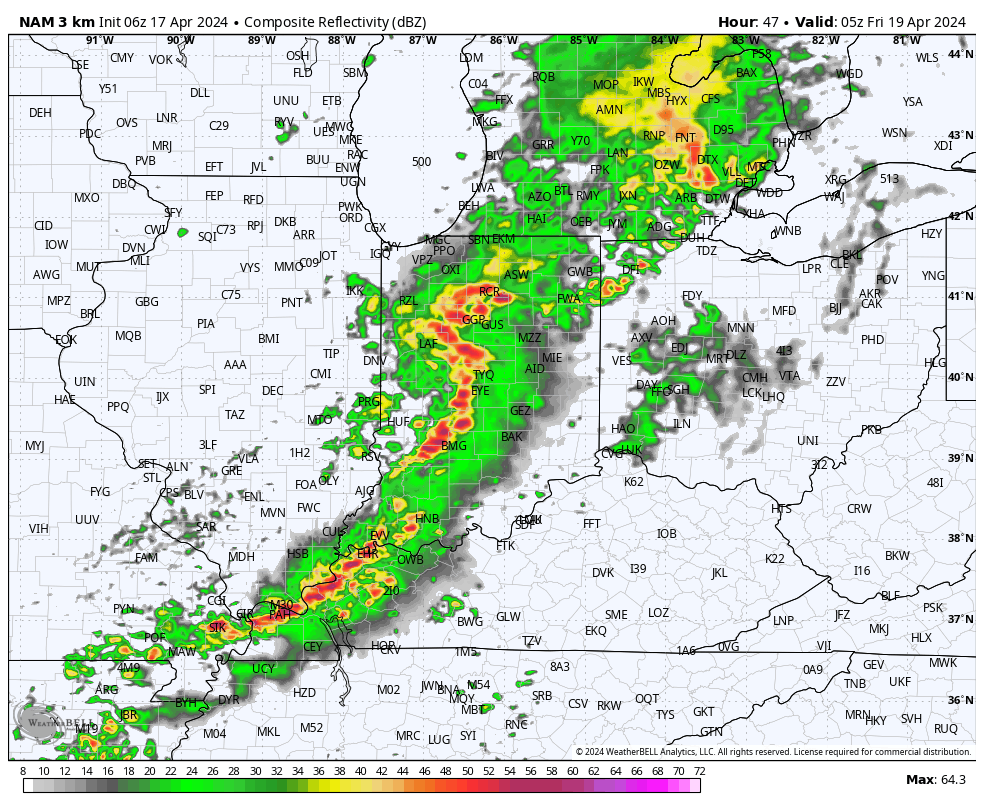
The day will start off quiet, but won’t end that way. We’re monitoring the threat of strong to severe storms later this evening, continuing into and through the overnight hours. The good news? All of these will be off to our east prior to heading out the door to work or school Friday morning. Then we can concentrate on a refreshingly cool weekend with sunshine returning.
While we’re still tracking storm potential today, there are a lot of questions around where these will initialize. Thinking here is right around the city, itself, and then points northeast (better chance of stronger storms for places like Fort Wayne and Muncie than Indianapolis-proper).
Storms should develop around or just after lunchtime (around 1p, or so) across central Indiana and then race off to the east. Damaging straight line winds are of greatest concern with the stronger storms. Non-thunderstorm wind gusts of around 40 MPH can also be expected today.
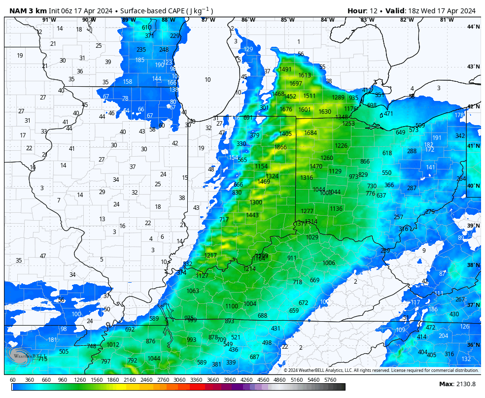
Instability levels are marginal at best today which, thankfully, should prevent widespread severe weather, locally.
A more stable airmass will quickly arrive tonight and remain in place through the daytime Thursday.
Our next round of storms, some of which will likely be gusty, will blow into town overnight into the predawn hours Friday.
High pressure is still slated to build in to allow for a much calmer (and cooler) weekend. Keep an eye on the potential for frost both Sunday and Monday mornings.