Improving Weather Through The Day…

Tue.

Wed.

Thr.

Fri.

Sat.

Sun.

Mon.

 Status-weather-showers-day-icon

 Status-weather-clouds-icon

 Status-weather-clouds-icon

 Status-weather-showers-day-icon

 Status-weather-clouds-icon

 Status-weather-clouds-icon

 Status-weather-clouds-icon

67/ 80

60/ 83

64/ 87

69/ 89

55/ 73

49/ 73

51/ 76 

Decreasing Rain Coverage; Increasing Sunshine…A shield of moderate to heavy rain encompassed the state during the overnight.  This shield of rain is slowly moving east, southeast and we’ll be looking at improving weather through the day.  There’s still the chance of a widely scattered thunderstorm late morning or early afternoon as a frontal boundary slides through the region.

Sunny Days…As we progress through the mid and late week stretch, we’ll enjoy dry skies and plentiful sunshine.  Normal lows and highs are in the lower 60s and lower 80s this time of year, so we’ll be very close to that Wednesday before moderating temperatures take us warmer than average to wrap up the work week.

Late Week Cold Front; Autumn Feel This Weekend…A cold front will slice into the warm and humid air mass Friday evening and lead to the possibility of a broken line of strong to potentially severe thunderstorms.  A MUCH cooler air mass will then invade the region behind the boundary, leading to a true fall-like feel this weekend!

7-Day Precipitation Forecast:

  • 7-Day Rainfall Forecast:  0.50″ – 0.75″
  • 7-Day Snowfall Forecast: 0.00″

John Salewicz sent us this beautiful sunrise photo Saturday morning before storms invaded portions of central Indiana.  Thanks, John!

BwSIn32CIAAqYL7


Are you craving cooler air to go along with that early season pumpkin spice latte? You'll be in luck this weekend as a true fall-like air mass invades...
Are you craving cooler air to go along with that early season pumpkin spice latte? You’ll be in luck this weekend as a true fall-like air mass invades…

Beneficial Steady Rains Coming Overnight…

I’m just getting settled back in from Auburn, AL, but wanted to update a couple of items before a complete 7-day post in the morning.

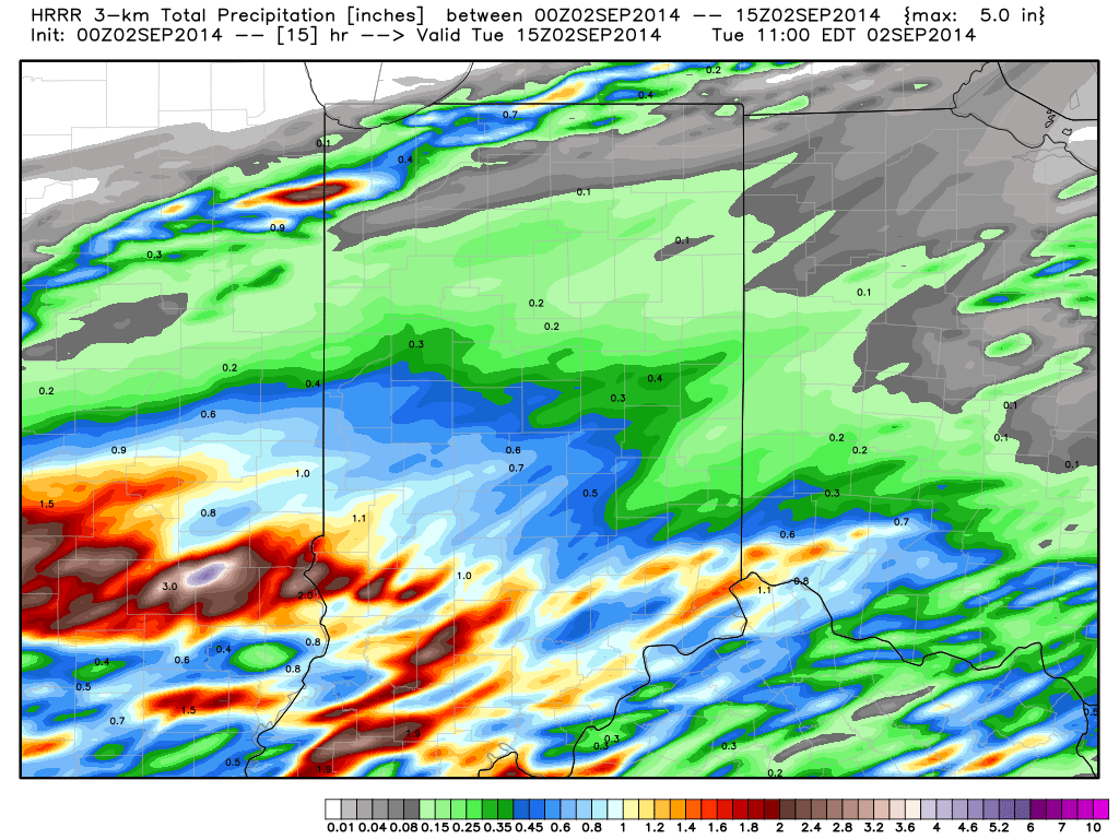
1.) Rain is continuing to become more widespread to our southwest and will overspread southern and central Indiana during the overnight into the wee morning hours Tuesday.  Most communities will accumulate 0.50″-1.00″ of needed rain, but a few locally heavier totals (closer to 2″) can be expected.  The HRRR forecast rainfall totals by 11am (when most of the rain will be ending across even our eastern counties) looks solid and we agree with this for the most part.  Note the heavier forecast totals across southwestern Indiana.

hrrr_t_precip_indy_16

2.)  A cold front will sweep the state Friday night into Saturday morning and result in a MUCH cooler weekend.  Temperatures will fall to well below normal levels (by 5-8 degrees on average) over the weekend and result in a perfect, early fall-like, feel!  Highs Saturday through Monday will likely only range in the lower to middle 70s with overnight lows in the lower 50s (a few readings into the 40s can be expected outside the city).

gfs_t2max_a_f_conus2_51

Watching Monday Evening Severe Potential…

The Storm Prediction Center has placed portions of the region under a Slight Risk of severe thunderstorms Monday. More specifically, we’re targeting Monday evening into the overnight for severe potential.…

You must be logged in to view this content. Click Here to become a member of IndyWX.com for full access.  Already a member of IndyWx.com All-Access?  Log-in here.

Uncategorized

Localized Downpours; Warm Close To August…

Sat.

Sun.

Mon.

Tue.

Wed.

Thr.

Fri.

 Status-weather-showers-day-icon

 Status-weather-showers-day-icon

 Status-weather-showers-day-icon

 Status-weather-storm-night-icon

 Status-weather-showers-day-icon

 Status-weather-showers-day-icon

 Status-weather-clouds-icon

70/ 84

69/ 85

70/ 88

70/ 83

62/ 85

67/ 88

68/ 90 

More Dry Hours Than Stormy…It’s hard to believe the long Labor Day holiday weekend is upon us.  The unofficial end to summer (by the way, meteorological fall runs September through November) will wrap up on an unseasonably warm note.  Southwesterly breezes will blow and transport plenty of warm and humid air northbound.  Needless to say, It’ll feel unseasonably warm and humid and scattered thunderstorms will be around.  High moisture content will help promote localized heavy downpours. That said, we’re certainly not looking at any sort of all day washouts by any stretch of the imagination.  Get outside and enjoy the late summer warmth, but just be prepared in case a shower or storm briefly blows overhead.

Better Rain And Storm Chances…Best rain chances in the above forecast period will arrive Monday evening into Tuesday. This is when we anticipate most widespread coverage of showers and thunderstorms, including the potential of a couple stronger storms and locally heavy downpours.  Slightly less humid air will work into the picture by mid week.

Remaining Above Normal…Rain chances can’t be totally eliminated from your forecast late next week, but overall coverage will likely be diminished when compared to Tuesday.  It’ll remain warmer than average with mid to upper 80s in the forecast (normal highs are around 80 this time of year) with a southeastern ridge in place.  In fact, many thermometers may crack the 90 degree mark next Friday.  We’re making up for lost time in the heat department…

7-Day Precipitation Forecast:

  • 7-Day Rainfall Forecast: 1.50″ – 2.00″
  • 7-Day Snowfall Forecast:  0.00″

John Salewicz snapped this Zionsville sunrise photo Friday morning.  “Follow the clouds to the sun…”  Thanks, John!

BwM321mCEAAoyW1.jpg-large

hires_ref_ky_22
Another slug of moisture will impact central Indiana Saturday. Not everyone will get wet and no all day rains are forecast, but there will be some periodic wet times.
Uncategorized

Muggy And Potentially Stormy IndySportsReport.com Football Forecast

Good morning football fans! Your IndySportsReport.com high school football forecast promises to be a warm and humid one with storm potential… A warm front will lift north through the region…

You must be logged in to view this content. Click Here to become a member of IndyWX.com for full access.  Already a member of IndyWx.com All-Access?  Log-in here.