 Highlights:
- Late night light freezing rain develops
- Milder and wet through mid week
- Ice storm potential on the rise late week
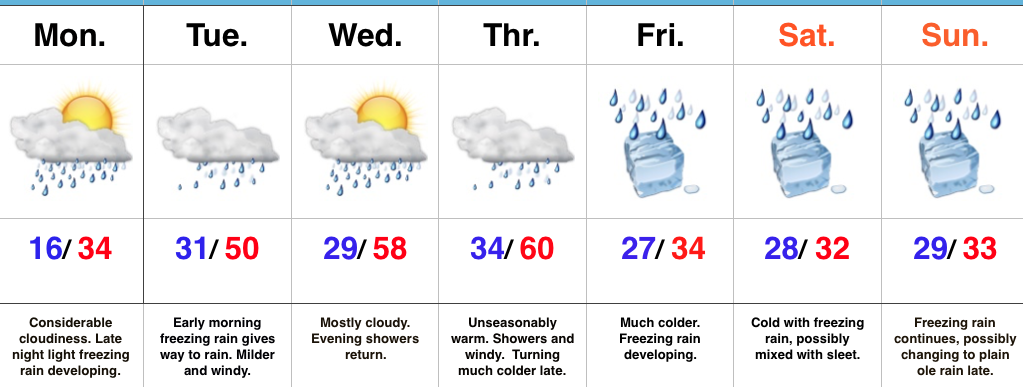
Feeling Downright Balmy Out…Temperatures this morning (writing this at 7a) are running close to 20 degrees above where we were this exact time Sunday. 20 degrees has never felt so warm! 🙂 This moderating trend will continue into mid week, including temperatures that approach 60 Thursday. That said, we have a mini “speed bump” to go over tonight and that’s the opportunity for light freezing rain late tonight into the wee morning hours Tuesday. Temperatures should go above freezing just before the morning rush Tuesday, but plan to leave additional time as slick spots may remain. Once we clear the “speed bump,” it’s off to the races in the temperature department through mid week: around 50 Tuesday afternoon and around 60 by Thursday (that’s a late night high Wednesday in the upper 50s). Periods of showers will come with the milder air, centered on Tuesday and late Wednesday into Thursday.
Unfortunately, the milder times don’t last long and we still forecast “trouble” late in the week. The set-up remains unchanged as a big, sprawling arctic high pushes into Wisconsin Friday. This will help “shove” the arctic front through Indiana before stalling along the Ohio River Friday into Saturday. As this is happening, ripples of energy will help ignite periods of precipitation Friday into the weekend. With cold air locked in at the surface, we expect the potential of a rather prolonged period of freezing rain developing late Friday and continuing into the weekend. We still have time for things to change, but from this distance, the predominant precipitation type, unfortunately, appears to be freezing rain. Stay tuned as this could be a high impact event.
Upcoming 7-Day Precipitation Forecast:
- Snowfall: 0.00″
- Rainfall: 1.50″ – 2.25″
