Updated 04.06.24 @ 11:06a We couldn’t ask for better weather today (after that cold start). You earned it, friends! Clouds quickly return Sunday and give way to late afternoon and…
You must be logged in to view this content. Click Here to become a member of IndyWX.com for full access. Already a member of IndyWx.com All-Access? Log-in here.
The upcoming “immediate term” forecast package has a little something for everyone: Good, Bad, and UGLY.
Let’s start with the “good” first, we should finally see drier air win out and get us back into the sunshine department Saturday. The trade off? Unseasonably cold conditions taking hold under those clearing skies tonight and diminishing wind. Most areas should wake up to the upper 20s come Saturday morning, but under that strong April sun angle, temperatures will zoom into the middle 50s by afternoon. Enjoy the badly needed vitamin D as it won’t stick around terribly long.
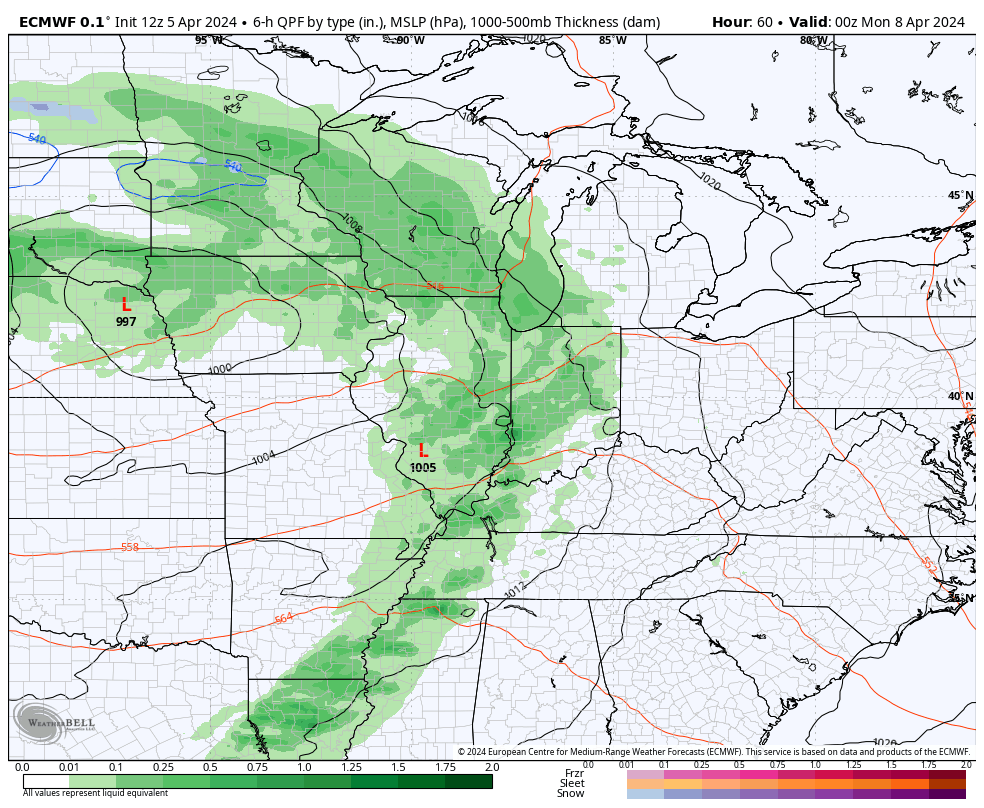
Our next storm system will deliver a round of gusty storms in here by Sunday afternoon and evening. Sunshine to start the day will give way to increasing clouds and scattered to numerous storms later in the day. We’re monitoring for the potential of a few strong-to-severe storms during this time period.
Storms return for the 2nd half of our weekend.
We still have our fingers crossed for a brightening sky to take hold Monday, but this isn’t a slam dunk by any means. – More of a now cast type situation if you ask us as the region will be in between systems. We’ll continue to hope for the best.
Regardless, active weather quickly returns midweek as a surface low rides northeast into the Ohio Valley. This will mean widespread rain and embedded thunder will return, and heavy rain is becoming increasingly likely.
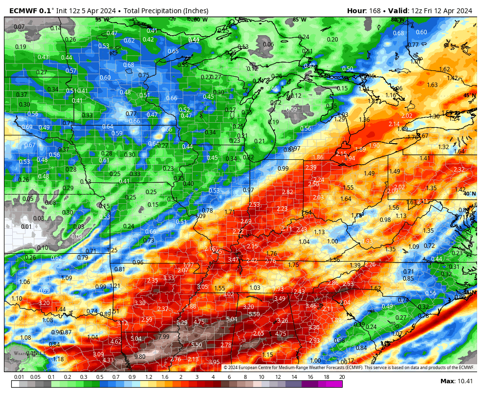
Heaviest rain likely arrives later Wednesday into Thursday followed by a gusty and briefly colder close to next week. By this point, early indications are that the region can expect another significant rain event, including widespread 2″+ totals (we’ll hone in on those amounts as we get closer).
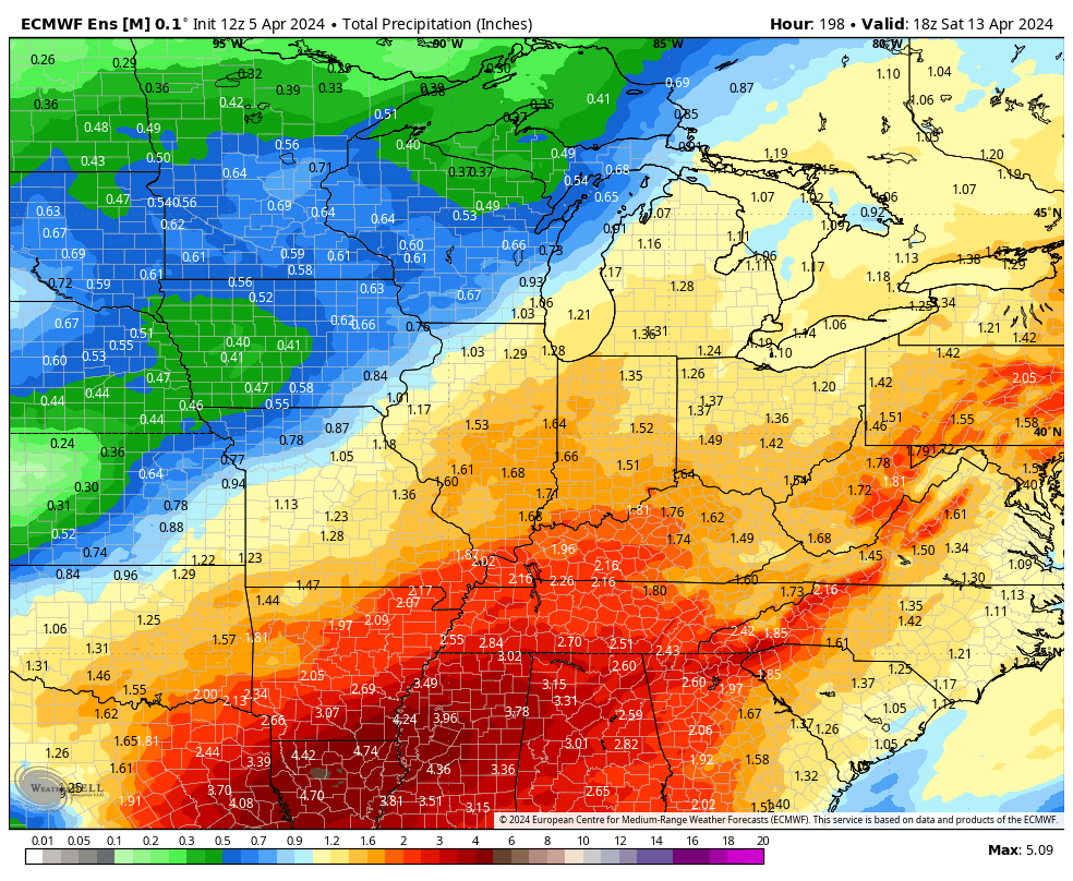
There’s ensemble support to back up the heavy rain idea.
Additional details to come throughout the weekend (and beyond) around these items and more.
Permanent link to this article: https://indywx.com/friday-afternoon-rambles-close-eyes-on-mondays-cloud-cover-and-gearing-up-for-another-active-week-of-hefty-rain-storms/
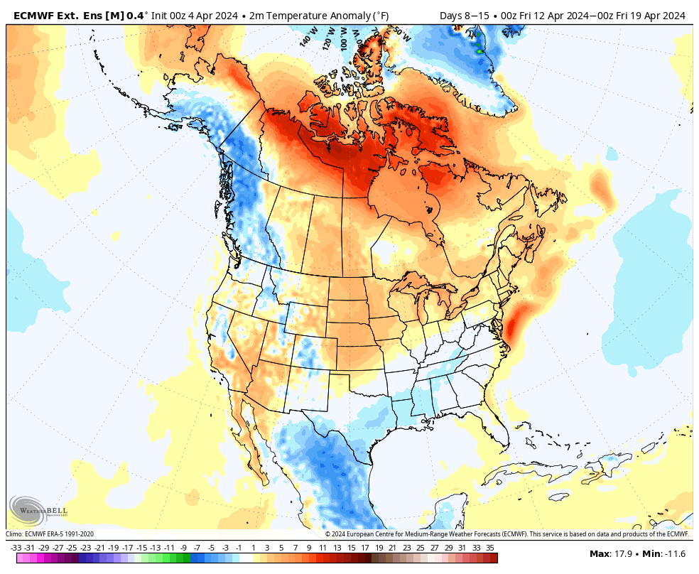
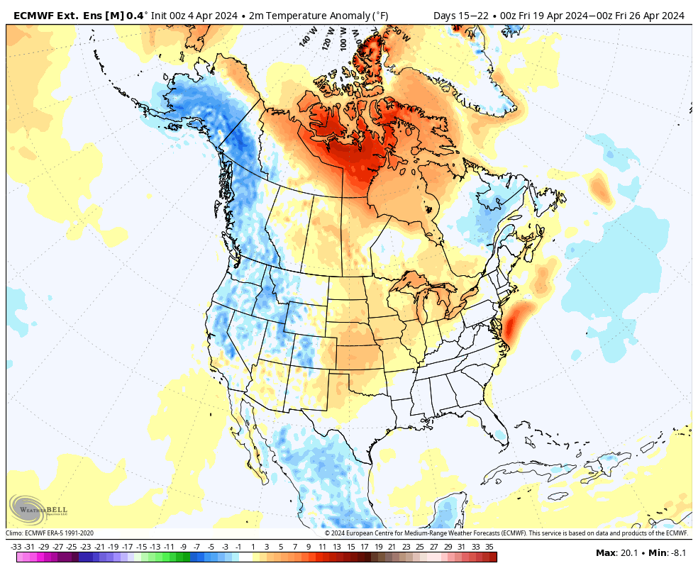
The overall chilly and unsettled pattern of late should show rather marked improvement not only over the short-term, but longer range, as well.
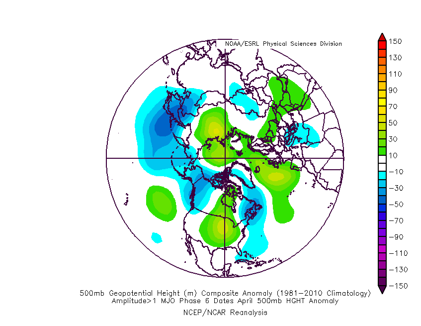
The teleconnection suite (AO, NAO, PNA, and EPO) over the next couple weeks is aligned in a manner that should promote less of an anomalous 500mb look, locally (deep eastern trough we’ve been dealing with).
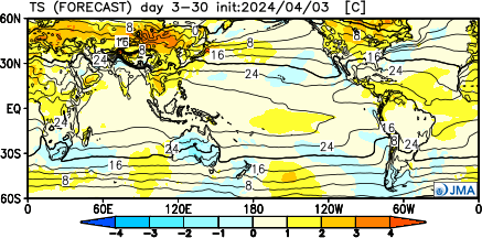
If we’re able to sneak into MJO Phase 6, then a warmer “lean” would be required by mid and late April. As always, we’ll keep an eye on those trends as the majority of data keeps the MJO in the neutral phase.
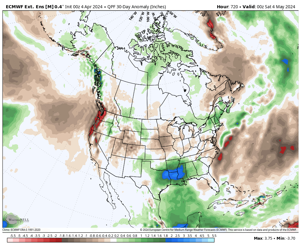
The thought here is that a milder and drier overall regime will take hold over the course of the next few weeks, certainly compared to late. That said, given the pattern drivers noted above, I also want to reiterate that we shouldn’t see rain or temperatures that differ significantly from average (rather only slightly above in the temperature department and slightly below in the precipitation department over the upcoming 4 week period). Further west, the better chance of more in the way of significantly above normal temperatures (primarily in the Plains).
The latest European and JMA Weeklies agree on this overall idea.
Updated 04.04.24 @ 7:40a A big ole upper low will move only sluggishly over the next day or two, keeping clouds, light precipitation, and chilly temperatures around. The good news?…
You must be logged in to view this content. Click Here to become a member of IndyWX.com for full access. Already a member of IndyWx.com All-Access? Log-in here.
Permanent link to this article: https://indywx.com/video-trending-in-the-right-direction-as-we-open-the-weekend-but-still-have-to-get-through-a-couple-damp-chilly-days/
Updated 04.03.24 @ 7:40a Clouds and showers (even embedded thunder by this afternoon) will transition to wet snow tonight into Thursday morning. The wet snow will fall heavily enough to…
You must be logged in to view this content. Click Here to become a member of IndyWX.com for full access. Already a member of IndyWx.com All-Access? Log-in here.