March 2024 archive

VIDEO: Weekend Sunshine; Tracking 2 Storm Systems In The Week Ahead And Looking At The Early-April Pattern…

Updated 03.23.24 @ 10:51a A quiet weekend will turn more active as we open the new work week. We’re tracking this system and another storm late in the week. Both…

You must be logged in to view this content. Click Here to become a member of IndyWX.com for full access.  Already a member of IndyWx.com All-Access?  Log-in here.

Permanent link to this article: https://indywx.com/2024/03/23/video-weekend-sunshine-tracking-2-storm-systems-in-the-week-ahead-and-looking-at-the-early-april-pattern/

Friday Morning Rambles: More Long Range Chatter…

Updated 03.22.24 @ 7:56a

The ‘mean’ trough position will take up shop across the western portion of the country over the upcoming week before shifting into the East in the 10-15 day period. We reiterate while the balance of the upcoming 2 weeks will run cooler than normal, we don’t see anything significantly colder than normal on the horizon and also plenty of transitional warmth ahead of approaching storms.

Note how the trough shifts east late in the period.

Day 1-5
Day 5-10
Day 10-15

Back to the immediate term, we’ll only see a few light showers later this afternoon (trace to 0.10”). Greatest coverage should arrive after lunch, continuing into mid-afternoon. Again, “light” is the key word.

Colder air arrives for the weekend, itself. We can expect mid to upper 20s both Saturday and Sunday morning.

A new, stronger, storm will blow into town with more in the way of widespread heavier rain and thunder Monday night into the day Tuesday.

Another system will follow late week and next weekend.

1” to 2” is a good bet across the greater region by next Sunday. (The bulk of this falls with our Monday night and Tuesday system).

Permanent link to this article: https://indywx.com/2024/03/22/friday-morning-rambles-more-long-range-chatter/

VIDEO: Light Rain Returns Friday; Cooler, Wetter Than Normal Pattern Anticipated O/ The Next 2 – 3 Weeks…

Updated 03.21.24 @ 7a The area will receive a glancing blow from our late week low pressure “tag team” that will deliver light rain Friday (most areas will be under…

You must be logged in to view this content. Click Here to become a member of IndyWX.com for full access.  Already a member of IndyWx.com All-Access?  Log-in here.

Permanent link to this article: https://indywx.com/2024/03/21/video-light-rain-returns-friday-cooler-wetter-than-normal-pattern-anticipated-o-the-next-2-3-weeks/

The Transitions Of Spring…

Updated 03.20.24 @ 4:45a

Up until this week, March was off to a toasty start. Despite the recent transition to cooler air, the month is still running nearly 9° above normal.

Another surge of chilly weather will descend into the state today. A hard freeze is dialed up Thursday morning.

Light rain Friday will interrupt the otherwise dry, quiet pattern we’ve been enjoying.

This will be a nuisance variety type of rain, along with “raw” conditions to close the work week. Despite the insignificant showers, this does signal another transition towards a wetter, more active pattern ahead next week.

We continue to watch the threat of a heavier rain/ stronger storm event Monday night into Tuesday followed by another soaker late week.

A more active pattern can be expected as we close the month of March.

While the pattern does look cooler than we started the month, I still don’t see any reason to beat the drum for out of season, “harsh” cold some other sources are signaling as we go through the next couple weeks- at least not for our neck of the woods.

Permanent link to this article: https://indywx.com/2024/03/20/the-transitions-of-spring/

VIDEO: Turning Gusty Later Today; Damp Close To The Work Week And Looking Ahead To A Chance Of Severe Weather Early Next Week…

Updated 03.19.24 @ 5:34a It’s a cold start to the day across central IN, but this time of year, especially with enough sunshine, we can warm-up nicely. That’ll be the…

You must be logged in to view this content. Click Here to become a member of IndyWX.com for full access.  Already a member of IndyWx.com All-Access?  Log-in here.

Permanent link to this article: https://indywx.com/2024/03/19/video-turning-gusty-later-today-damp-close-to-the-work-week-and-looking-ahead-to-a-chance-of-severe-weather-early-next-week/

Quiet Open To The Week Gives Way To More Active Times…

Updated 03.18.24 @ 7:55a

The story to open the work week will be a quiet one. For a change, we’re talking about a chilly air mass settling overhead. That colder air will also feature a return of drier times.

Despite a few scattered light snow showers today, we’ll stay on the dry side until Friday.

Multiple hard freezes can be expected this week. Tuesday morning will once again feature lows deep into the 20s area-wide.

The good news? Sunshine and calm conditions can be expected during the majority of the week ahead.

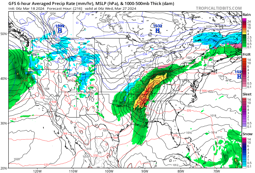
That will all change by Friday as a couple low pressure systems team up to return unsettled weather to our region. Friday looks wet and chilly as of now. Rain won’t be heavy, but more of a nuisance. It’ll be a good day to hunker down and watch Day 2 of the tourney. 🏀

Though Friday won’t feature a significant storm system, it will signal a change for a more active Week 2. Heavier rain and the possibility of stronger storms can be expected next week and we’ll have more details on this as we navigate the coming days.

Permanent link to this article: https://indywx.com/2024/03/18/quiet-open-to-the-week-gives-way-to-more-active-times/

VIDEO: Weekly #AGwx And #Severe Weather Outlook…

Updated 03.17.24 @ 8:10a The theme for the bulk of the week ahead will be both cooler and drier. A few mornings will feature a hard freeze, including overnight lows…

You must be logged in to view this content. Click Here to become a member of IndyWX.com for full access.  Already a member of IndyWx.com All-Access?  Log-in here.

Permanent link to this article: https://indywx.com/2024/03/17/video-weekly-agwx-and-severe-weather-outlook/

Long Range Report: Cooler, Drier Week 1 Turns Wetter To Close March; Open April…

Updated 03.16.24 @ 7:55a

Indianapolis is running right at average month to date from a rainfall perspective (1.78”).

We’re transitioning to a much drier pattern in the week ahead as a cooler, Canadian airmass dominates (for a change).

Several hard freezes (mid-upper 20s) are on tap in the upcoming 7-10 day period: Monday/ Tuesday morning and again late next week/ next weekend.

Cooler? Yes, but I still don’t see anything overly cold on the horizon as we navigate the next couple of weeks.

What’s more notable is the shift in the precipitation pattern over the next few weeks. The dry Week 1 (now) transitions to a significantly wetter and more active look Week 2 (below).

The JMA also sees the wetter regime.

This is forecast to continue in the Weeks 3/4 timeframe.

Continues to back up the idea of an active (wet) and stormy (more in the way of severe weather) spring as a whole.

Down the road, an eventual move into a hot, dry (compared to normal) summer may loom. (Yet one that is very active from a tropical perspective, continuing into the fall). More on that in the coming weeks…

Permanent link to this article: https://indywx.com/2024/03/16/long-range-report-cooler-drier-week-1-turns-wetter-to-close-march-open-april/

VIDEO: Cooler Air Flows In; Impacts On Precipitation Over The Upcoming Couple Of Weeks…

Updated 03.15.24 @ 7:29a After a busy and noisy Thursday, we are thankfully able to calm things down in significant fashion today. A narrow (insignificant) band of showers may impact…

You must be logged in to view this content. Click Here to become a member of IndyWX.com for full access.  Already a member of IndyWx.com All-Access?  Log-in here.

Permanent link to this article: https://indywx.com/2024/03/15/video-cooler-air-flows-in-impacts-on-precipitation-over-the-upcoming-couple-of-weeks/

Client Brief: Severe Weather Episode On Track Tonight…

Updated 03.14.24 @ 4:16p

Type: Severe Weather Outbreak

What: Severe weather outbreak

When: Tonight between 6p and midnight

Wind: Potential of straight line winds in excess of 60 MPH

Temperatures: Lower 70s falling into the 40s after midnight

Summary: While all is quiet on the radar as we type this, things will change quickly through the next hour, or so. We anticipate storms to initialize across the region around 6p and quickly intensify. Downstream radar and satellite trends pose a concerning look this afternoon, including several super cells and this activity is expected to expand into central IN through the evening. All modes of severe weather are possible, including large hail, damaging winds, and a few tornadoes. Please heed all warnings and have your severe weather safety plan activated through the evening. Thankfully, we still anticipate rapidly improving conditions north to south towards 11p to midnight.

Confidence: High

Permanent link to this article: https://indywx.com/2024/03/14/client-brief-severe-weather-episode-on-track-tonight/

IndyWx.com