April 2023 archive

About As Quiet As It Can Get For An Extended Period…

Updated 04.07.23 @ 6:47a

There’s no reason to waste pixels with the forecast package over the upcoming week (and likely beyond) as we’ll enjoy about as quiet and uneventful of a pattern as we can ever ask for- certainly in early to mid April.

High pressure will build overhead and remain in control of our pattern deep into next week. This means we can expect dry conditions straight into next weekend.

Not only that, but temperatures will moderate in significant fashion next week as well. The “step-up” into the 70s complete with plenty of sunshine will be mighty nice…

The active pattern will return eventually, but just let us worry about that and you be sure to soak in the extended period of gorgeous conditions.

Permanent link to this article: https://indywx.com/about-as-quiet-as-it-can-get-for-an-extended-period/

VIDEO: Improving Weather Heading Into The Easter Weekend; Long Range Update…

Updated 04.06.23 @ 7:59a

You must be logged in to view this content. Click Here to become a member of IndyWX.com for full access.  Already a member of IndyWx.com All-Access?  Log-in here.

Permanent link to this article: https://indywx.com/video-improving-weather-heading-into-the-easter-weekend-long-range-update/

Stormy Day Ahead Of A Gorgeous Easter Weekend…

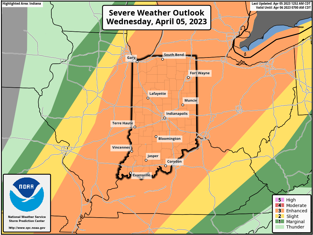
Updated 04.05.23 @ 7:13a

Today is one of those days where it will be important to remain weather-aware and have a means of getting the latest warnings that will likely be issued. The Storm Prediction Center (SPC) continues to include all of the state in an ‘enhanced risk’ of severe weather today. All modes of severe weather are in play with the greatest emphasis placed on damaging straight line wind potential, but a couple of tornadoes can’t be ruled out. Large hail is also possible, especially if we get discrete cells to pop ahead of the main line later this afternoon (more on that below).

Out the door this morning, it’s easy to understand the environment is one conducive of stormy weather. We’re already in the middle 70s at the 7a hour (that will be close to our high today) and dew points are into the lower to middle 60s. Instability will increase in the coming hours and it won’t be long before a Severe Thunderstorm or Tornado Watch is issued for a part, if not most, of the state.

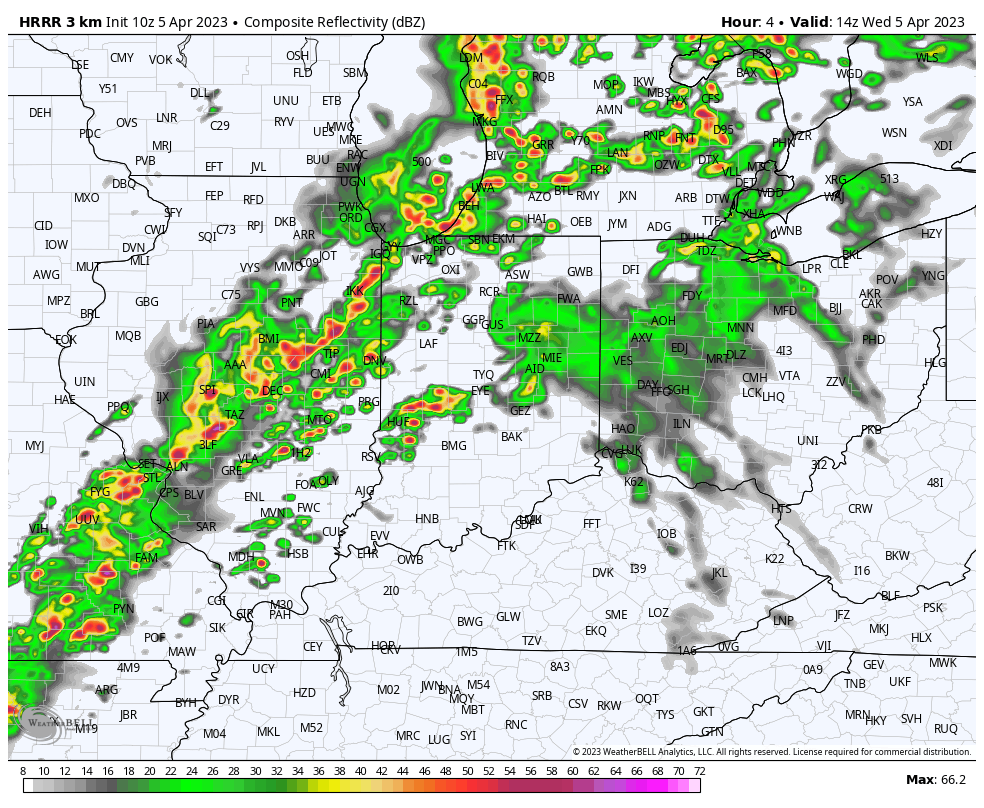
As we time out the arrival of storms, we think things unfold in 2 waves today. The first round of storms likely comes from individual cells, or clusters, mid to late morning. These will be scattered in nature but have the potential to rotate and also produce large hail.

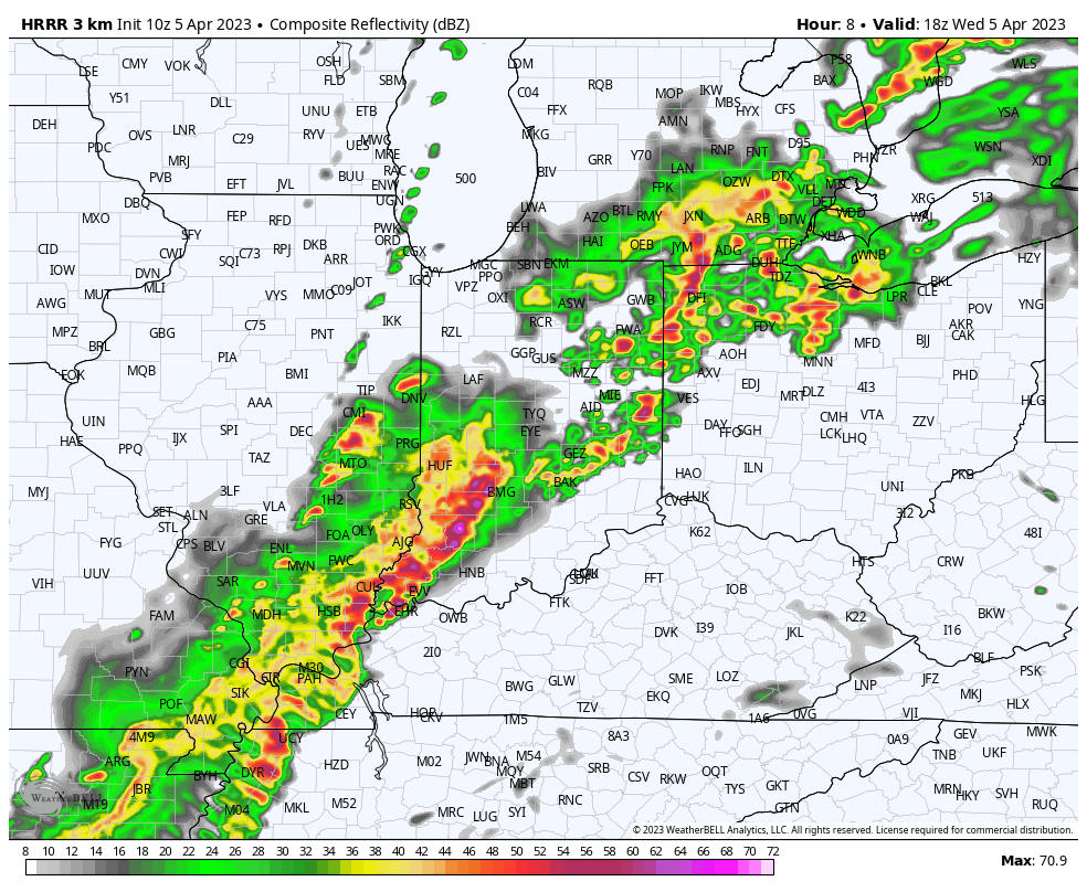
The 2nd wave will come from a more widespread squall line and that’s where we anticipate the greatest opportunity of damaging straight line winds. Please note this doesn’t mean there still couldn’t be a quick spin-up tornado embedded within the squall line.

The other item to add here has to do with gradient winds that will approach 50 MPH even outside of thunderstorms. If you haven’t already, we’d highly encourage bringing in or securing any loose objects that could easily be blown about.

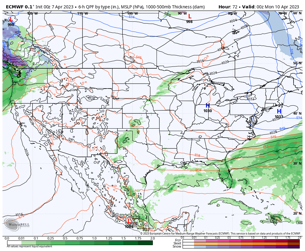
Weather conditions will rapidly improve from west to east as we move into the evening hours and this will set the stage for the remainder of the week, including our Easter weekend. High pressure will build overhead and supply an extended stretch of sunny days and calm nights, including lows in the 30s and highs in the 50s, eventually warming into the 60s for highs this weekend, and into the 70s early next week.

Please be sure to remain weather-aware today and heed any warnings that will likely be issued in the coming hours.

Permanent link to this article: https://indywx.com/stormy-day-ahead-of-a-gorgeous-easter-weekend/

Latest Details On Severe Threat; Timing Of Storms Wednesday; Looking Forward To A Nice Easter Weekend…

Updated 04.04.23 @ 5:34a

You must be logged in to view this content. Click Here to become a member of IndyWX.com for full access.  Already a member of IndyWx.com All-Access?  Log-in here.

Permanent link to this article: https://indywx.com/latest-details-on-severe-threat-timing-of-severe-storms-wednesday-looking-forward-to-a-nice-easter-weekend/

VIDEO: Strong-Severe Storm Threat Tuesday Night Into Wednesday; Gorgeous Weather Heading Into Easter Weekend…

Updated 04.03.23 @ 7:55a

You must be logged in to view this content. Click Here to become a member of IndyWX.com for full access.  Already a member of IndyWx.com All-Access?  Log-in here.

Permanent link to this article: https://indywx.com/video-strong-severe-storm-threat-tuesday-night-into-wednesday-gorgeous-weather-heading-into-easter-weekend/