Updated 12.21.22 @ 6:42p
You must be logged in to view this content. Click Here to become a member of IndyWX.com for full access. Already a member of IndyWx.com All-Access? Log-in here.

Dec 21
Updated 12.21.22 @ 6:42p
You must be logged in to view this content. Click Here to become a member of IndyWX.com for full access. Already a member of IndyWx.com All-Access? Log-in here.
Permanent link to this article: https://indywx.com/2022/12/21/detailed-video-discussion-on-the-blizzard-conditions-ahead-and-the-longer-range-january-pattern-drivers/
Dec 21
Updated 12.21.22 @ 1:31p
Type: Severe Winter Weather
What: Heavy snow, blizzard conditions, dangerously cold temperatures
When: Thursday PM through Christmas Eve
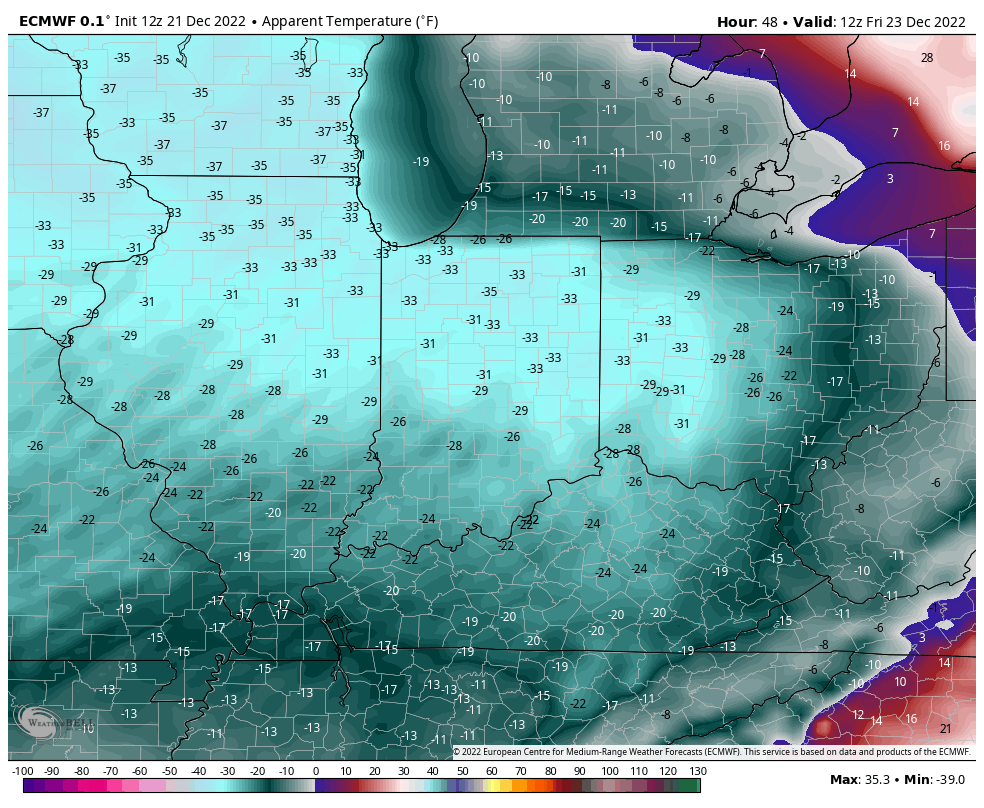
Temperatures: Falling from the upper 30s (Thursday afternoon) to 0° to 10° below zero (Friday morning).
Wind: WSW 15-25 MPH, increasing to 25-40 MPH with gusts to 50 MPH
Blowing/ Drifting: Severe
Pavement Impacts: Plowing and salting will be required throughout the region.
Summary: Precipitation is anticipated to overspread central IN Thursday morning in the form of a light cold rain. Light rain will continue into the early afternoon hours with temperatures ranging anywhere from the mid to upper 30s. The arctic front will arrive into the city, itself around 4p to 5p and this is when we expect rain to quickly change to snow. As this takes place, surface low pressure is expected to ride northeast from southwest IN into northwester/ north-central Ohio, allowing a blossoming area of more widespread, heavier snow to fall across the region Thursday evening, continuing through the overnight period. To make matters more hazardous, temperatures will fall from the aforementioned mid-upper 30s early afternoon into the single digits by 9p to 10p. The rapid temperature fall will allow any/ all moisture to freeze and further complicate travel with the increasing snowfall rates.
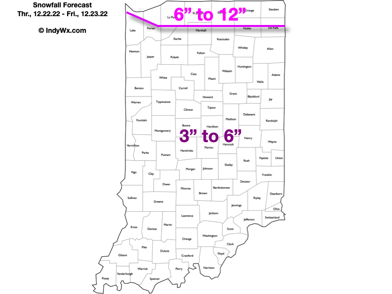
Forecast models this afternoon are split between (2) camps: the weaker and more progressive NAM and European, and the more “revved up” GFS and Canadian guidance. With that said, we’ll lean towards the European/ NAM blend to build our snowfall forecast below (good luck measuring whatever falls ;-)), but will continue to keep a close eye on trends through the evening and tonight. Side note: We’ll have a more detailed video discussion posted this evening that will dive into the very latest data trends with our current storm, look ahead to another snow maker on deck early next week, a significant warm-up, and subsequent return of cold, wintry conditions.
If all of this wasn’t enough, winds will increase in speed and turn gusty through the evening Thursday, continuing into and through the day on Friday, as well as Christmas Eve. Periodic gusts upwards of 40 to 50 MPH will lead to severe blowing and drifting snow, whiteout and blizzard conditions during this period. We strongly advise against traveling Thursday evening through Friday. “Wrap around” lighter snow and snow showers are expected to continue through the day Friday with temperatures struggling to make it much above the 0° mark. Severe blowing and drifting snow and blizzard conditions will continue Friday to combine with the dangerous cold.
The prolonged nature of such strong winds, combined with expected snowfall amounts will continue to lead to hazardous travel through Christmas Eve. Unfortunately, winds aren’t expected to diminish until Christmas morning. By this point, all eyes will be focused on the next snow maker due in here late Christmas night or early Monday in the form of a clipper system.
More on all of this later this evening in our updated video discussion.
Confidence: High
Next Update: By 7p Wednesday (video discussion)
Permanent link to this article: https://indywx.com/2022/12/21/client-brief-dangerous-cold-blizzard-conditions-arrive-thursday-night-into-friday/
Dec 21
Updated 12.21.22 @ 6:40a I. We still have another 24 hours where weather won’t have any sort of impact across central Indiana. Dry conditions will hold through early Thursday morning.…
You must be logged in to view this content. Click Here to become a member of IndyWX.com for full access. Already a member of IndyWx.com All-Access? Log-in here.
Permanent link to this article: https://indywx.com/2022/12/21/wednesday-morning-notes-on-our-upcoming-winter-storm/