
Updated 10.28.22 @ 6a
Well here we are again, time for another stab at what the exciting winter months will provide. Time flies when you’re having fun; it’s incredibly hard to believe this will be our 13th winter outlook issued at IndyWx.com! Some of those years have been a lot more accurate than others, but so it goes with seasonal forecasts. One thing to take away from this report: no one winter (or any season, for that matter) is identical to another.
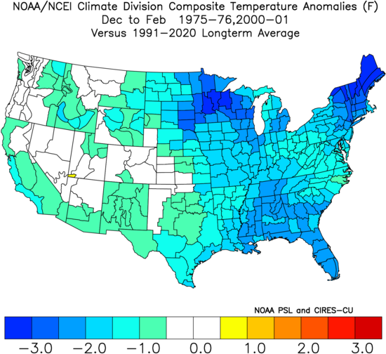
When we look at the current SST (sea surface temperature) configuration, the first thing that likely jumps out is all of that cool water in the equatorial Pacific. We’re heading for our 3rd consecutive La Nina winter, which is quite a rarity. In fact, we have to go all the way back to the winter of ’00 – ’01 and then ’75 – ’76 to find other triple dip Nina events. To no surprise, these are the (2) leading analog years.

But it’s not just the cool anomalies in the Pacific that have our attention, we note the warmer anomalies in the northeast Pacific, the northwest Atlantic, and across the northwest Pacific.
Research into these particular areas with warmer than normal sea surface temperatures tend to favor the following for winter:
I. Northwest Pacific SST state: Colder than normal from the Northwest, northern Plains, and into the western Great Lakes. Warmer than normal along the eastern seaboard.
II. Northeast Pacific SST state: Colder than normal across the Northwest, Northern Plains, and into the western Great Lakes/ upper Mid West.
III. Northwest Atlantic SST state: Warmer than normal across New England, cooler than normal ribbon from the upper Midwest through the Ohio Valley, and into the Southeast.
When we blend the 2 primary analog years, this is what the winter (December through February) as a whole looks like:
Temperatures
Precipitation

We’ll then add in the additional research from the “focal” SST areas noted above when building our finished product.
“Traditional” (always hesitant to use that word when it comes to looking at an upcoming season) La Ninas favor the following:

Remember, we’re in rare territory with this being a 3rd consecutive Nina. We’re expected to remain in a Nina state through the winter and upcoming spring before potentially flipping the page and moving into an El Nino next summer or fall.
The Madden-Julian Oscillation will also have an important say into what the upcoming winter holds. Last year the cold November turned into a blow torch of a December (thanks to the MJO rolling into the warmer phases for December).

There are reasons to believe the sea surface temperature configuration over the Pacific will nudge the MJO into more favorable phases for cold mid-late Nov and Dec this year. Add in the fact that this is a rare triple dip Nina, and the ante is upped that this year will feature a much faster start to winter for a change. If that’s, indeed, the case, winter enthusiasts should enjoy every bit of the cold and potentially wintry “fun” that would ensue. The reason? The same drivers that should promote the early start to winter will likely have a say in pulling the ‘mean’ trough back into the west with more tendency for eastern ridging and associated warmer than normal temperatures as we move through January and into February.
Finally, there are additional “wild cards” that are much more difficult to predict more than 2-3 weeks out and those are the AO and NAO. These teleconnections have a much greater influence on our pattern by mid and late winter, but are more of a “now cast.”
What does this all mean to me: Central Indiana
Overall, we think the winter will get off to a much quicker, harsher start than years past. In particular, the period from Thanksgiving to New Year’s should run colder than normal and one could easily build a case that we will also be looking at above the normal snowfall during the period (average being 7.1″ during the aforementioned period).
As we get into January, the pattern drivers will likely begin to transition through the month that results in a milder pattern engulfing much of the east while the colder regime shifts north and west. An expected active storm track is on tap for mid and late winter, locally, favoring above average precipitation. With an expected milder flow and more transitional cold during this time, it’s not to say we would be done with the wintry precipitation, but it’ll likely start to become increasingly difficult for “meaningful” precipitation makers to have cold readily available.
Temperatures: After the cold start to winter, warmer times should win out mid and late winter. We forecast December through February, as a whole, to run 1° above normal.
Precipitation: Above normal precipitation is expected through the 3 month winter period (125% of normal is our call) with slightly below normal snowfall. While the late November through early January period will likely have us ahead of times in the snowfall department by early ’23, the idea here is that the majority of the rest of winter will feature little in the way of significant snowfall. Our call is 20″ on the year (compared to an average of 25.5″).
Whatever the winter provides, I hope you and your family enjoy and stay safe!