Updated 02.11.21 @ 7:55a
You must be logged in to view this content. Click Here to become a member of IndyWX.com for full access. Already a member of IndyWx.com All-Access? Log-in here.

Feb 11
Updated 02.11.21 @ 7:55a
You must be logged in to view this content. Click Here to become a member of IndyWX.com for full access. Already a member of IndyWx.com All-Access? Log-in here.
Permanent link to this article: https://indywx.com/2021/02/11/video-long-hours-in-the-forecast-office-ahead/
Feb 10
Updated 02.10.21 @ 6:23p
Before we look ahead, snow continues to fall across most of central Indiana. So far, immediate downtown Indy has avoided significant snow, but other areas are approaching 1″ to 2″ already as of this post. We continue to believe another band of snow will organize during the overnight into the predawn hours across central Indiana (especially along and north of the I-70 corridor). Given how cold it’s been as of late, even the lightest snow is creating havoc on area roadways. As winds become gusty, blowing and drifting issues will remain into the day Thursday.
As we look ahead, this pattern remains nothing short of remarkable. Feb. 5th (last Friday at 6p) was the last time Indianapolis was above the freezing mark. As we look ahead, we’re likely talking about another 12 days below freezing (if not longer). The “moderation” that some models are hinting at after that time frame isn’t something I’d label as high confidence at this point. That’s rare territory for central Indiana- even during some of the infamous cold winters of the “good ole days.” There’s also already been a fair share of snow events in this pattern. Sure the big one hasn’t hit (yet), but many across the state are getting used to clearing snow off the sidewalk and driveway on a daily basis. Not counting today’s snow, Indianapolis, officially, sits at 2.3″ month-to-date. Areas downstate received as much as half a foot (or more) earlier this week. As we look ahead, there’s a lot more white gold where that came from. (Keep in mind, the “average” snow total during the month of February in Indianapolis is 6.5″).
A fresh intrusion of arctic air will arrive just in time for the weekend. We’re looking at a mostly dry stretch of weather through the weekend, with the exception of some light snow prospects Saturday. Again, given how cold it’s been, even these light snow events will likely create travel trouble.
The coldest morning appears to be Sunday with lows falling to between 3° and 6° below zero. Wind chill values will approach 20° below zero, or worse, in spots.
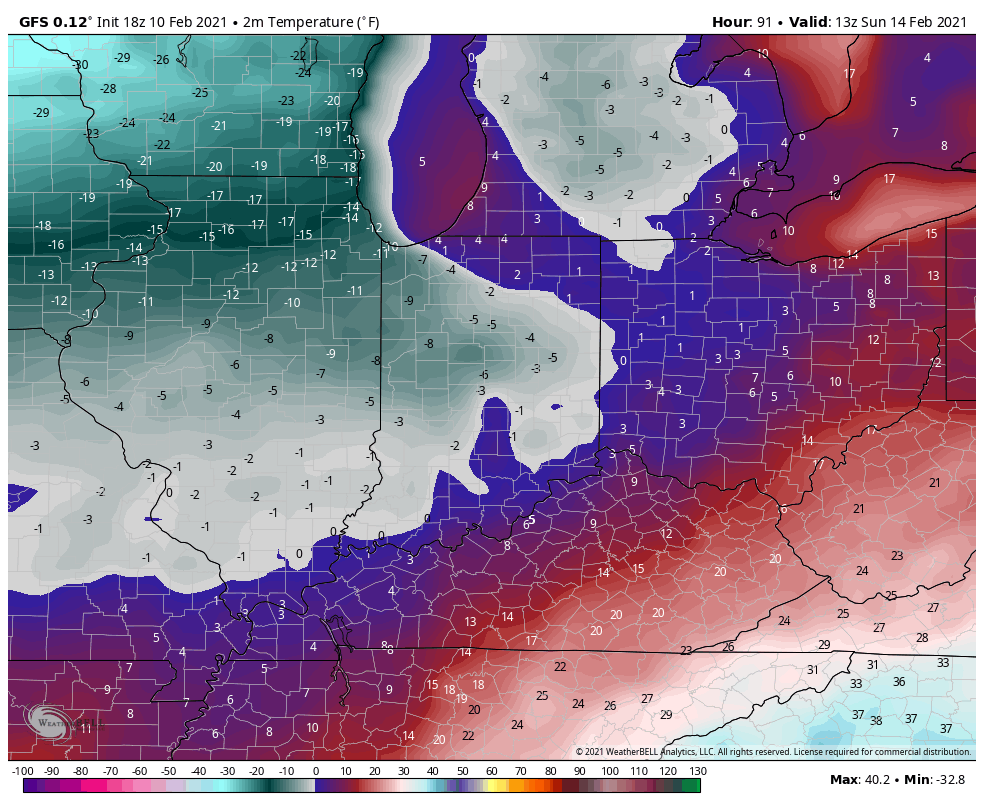

By this time, all eyes will be on the developing storm system in the northwest Gulf of Mexico. There’s already been a great deal of chatter about this storm and that will only continue to ramp up as we move forward. Given the overall pattern and model consensus at this juncture, there’s plenty reason to believe the Ohio Valley, including central Indiana, is in store for a significant winter storm early next week.
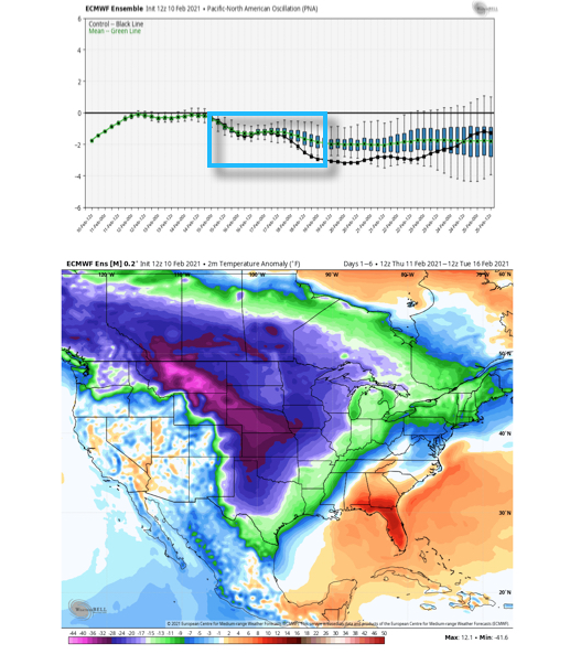
With that said, nothing is a lock in this business. While the negative PNA (image 1 below) argues for the southeast ridge to “flex” it’s muscle and lead to a more inland track, the fact arctic air will be pressing southeast (image 2 below) does at least raise an eyebrow for potential shifts southeast in time over the next couple of days. It’s another fascinating meteorological battle we’ll have the pleasure to watch unfold in real time.
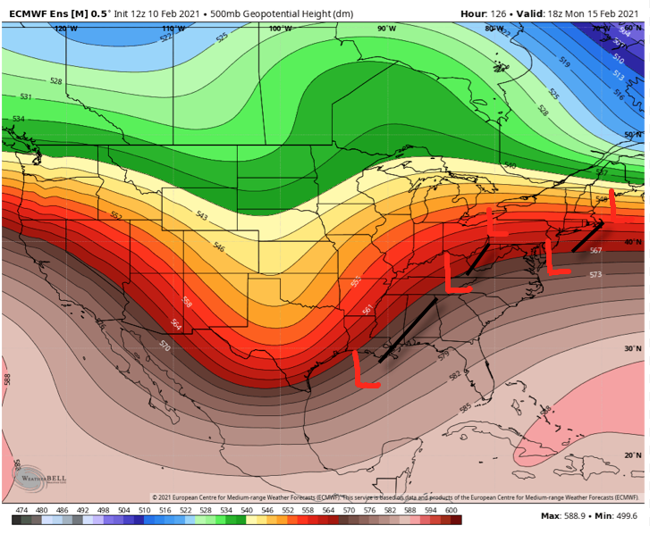
As it sits right now, we favor a storm track that will be far enough west to put central Indiana in play for potentially significant wintry precipitation (far too early to throw numbers out). The early call is for surface low to move out of the northwest Gulf and track west of the mountains before a secondary low take over along the Mid-Atlantic and moves northeast off the New England coast.
If this wasn’t enough, another storm system likely follows later next week that could also produce additional wintry “goods.”
Will every storm produce in your backyard? Negative. That said, when we get to March 1st, central Indiana winter weather fans are likely to look back on February 2021 as a truly special ride.
I suppose time will tell…
Permanent link to this article: https://indywx.com/2021/02/10/reasons-for-and-against-the-big-one-next-week/
Feb 10
Updated 02.10.21 @ 8:30a
You must be logged in to view this content. Click Here to become a member of IndyWX.com for full access. Already a member of IndyWx.com All-Access? Log-in here.
Permanent link to this article: https://indywx.com/2021/02/10/video-the-beat-goes-on-looking-at-the-pattern-into-late-month/
Feb 09
Updated 02.09.21 @ 7:15p
Type: Impactful Wintry Weather
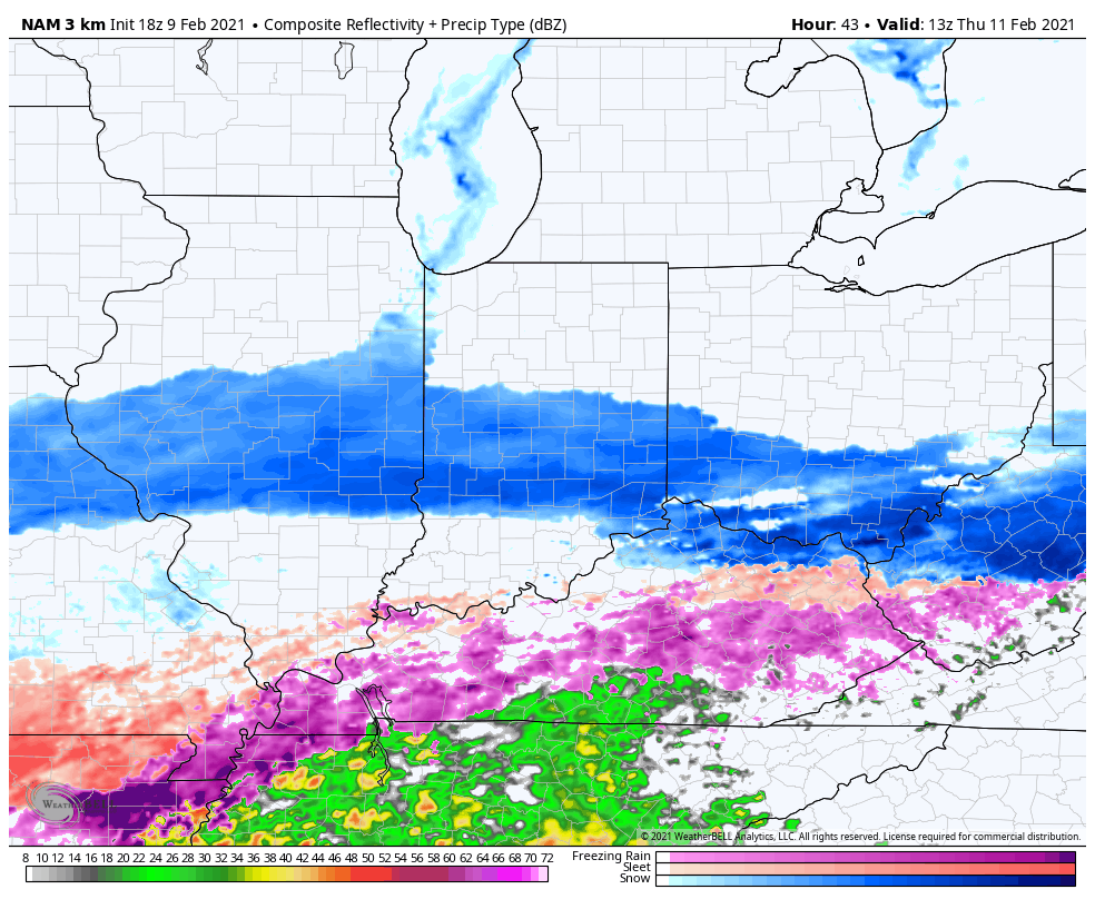
What: Accumulating snow
When: Late Wednesday morning through Thursday afternoon
Temperatures: 18° to 24°
Wind: NE 10 – 20 MPH and gusty
Blowing/ Drifting: Considerable
Pavement Impacts: Plowing and salting will be required
Summary: Wednesday will dawn with quiet conditions in place but snow will arrive into central Indiana by late morning. Initially, we’re only talking about light snow into the afternoon and evening. Snow will become more widespread and heavier throughout the “heart” of central IN during the overnight hours and Thursday morning before eventually giving way to lighter snow Thursday afternoon, eventually ending from west to east. Downstate, a mix of freezing rain, sleet, and brief snow is expected, including icy travel. Once again, this will be an efficient snow producer. Instead of snow ratios of 10:1 we expect closer to 15 to 20:1 ratios (similar to that of what southern parts of the state experienced Monday). The dry, powdery nature of the snow will combine with gusty northeast winds to create blowing and drifting issues by Wednesday evening through Thursday, especially in the open country. Gusty winds will persist Thursday night even as the snow comes to an end, extending the blowing and drifting concerns.
Confidence: High
Next Update: Wednesday morning (video)
Permanent link to this article: https://indywx.com/2021/02/09/client-brief-another-round-of-accumulating-snow-on-deck-blowing-drifting-also-to-be-dealt-with/
Feb 09
Updated 02.09.21 @ 8a

Keep That Head On A Swivel…Before we talk about what’s ahead, it was a snowy night across south-central Indiana. Many of the reports coming in from down that way indicate our 3″ to 5″ forecast played out quite nicely, including most common snowfall totals between 4″ and 5″ (with a few isolated heavier amounts). Thank you for those ground truth reports, friends! I know we’ve said it before, but they are more valuable than you know!
Now to look ahead. Storm systems will come flying through fast and furious over the upcoming 7-days. Scattered lingering snow showers and flurries today will give way to a steadier snow as we move into Wednesday. Meanwhile, an icy mixture of sleet and freezing rain is expected across far southern Indiana. After the 12z model suite is complete this afternoon, we’ll be back with a fresh look on expected snowfall amounts later this evening.
Friday appears to offer up a much needed one day breather from wintry systems with cold, dry conditions expected. Then our attention will shift to the weekend and threat of potentially a more significant winter storm. Guidance is trying to sort out which feature has the best chance of phasing into a more potent storm system. The GFS likes the lead wave this weekend while the European holds things off until early next week. Please stay tuned.
Permanent link to this article: https://indywx.com/2021/02/09/02-09-21-weather-bulletin-active-would-be-an-understatement/
Feb 08
Updated: 02.08.21 @ 5:35p
You must be logged in to view this content. Click Here to become a member of IndyWX.com for full access. Already a member of IndyWx.com All-Access? Log-in here.
Permanent link to this article: https://indywx.com/2021/02/08/video-cold-snowy-pattern-locking-in-for-the-foreseeable-future/
Feb 08
Updated 02.08.21 @ 8:32a
Most of the daytime today will only feature light snow, but don’t let that fool you. With such a cold, arctic airmass in place, even the “light” snow is creating travel issues in spots. Take it slow out there, friends.
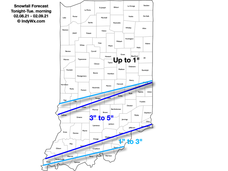
A new piece of upper level energy will streak across the region tonight and help snow to become more organized in aerial coverage. A narrow, but efficient band of steadier snow is expected to get going across south-central Indiana around, or just after, sunset. It’s within this snow where we expect several inches of snow to accumulate tonight and early Tuesday morning.
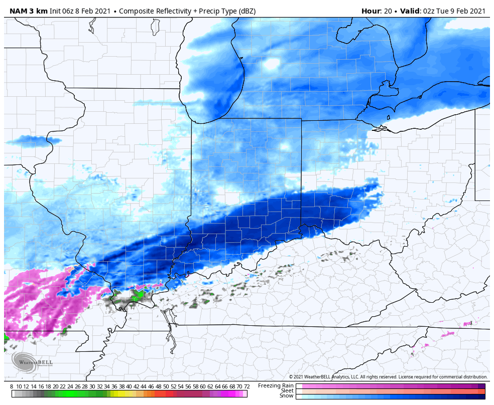
Most of the steady snow will exit to the east before sunrise Tuesday. We’ll then be left with periods of flurries and light snow through the remainder of the day.
Here’s our snowfall forecast with tonight’s system:
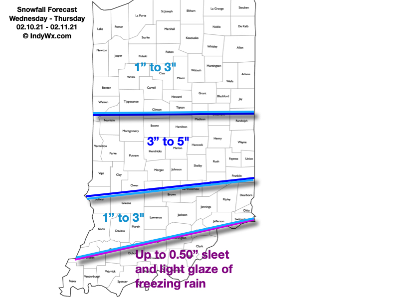
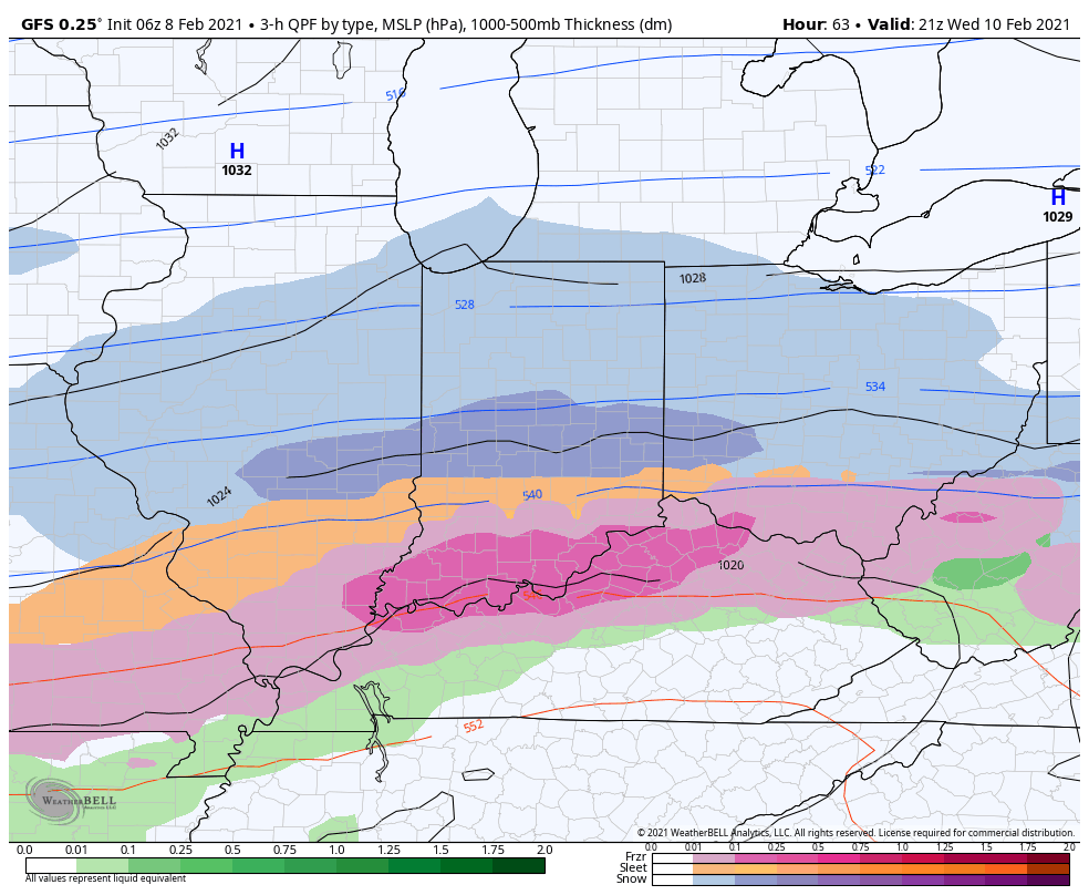
Attention will then shift to a “juicier” midweek storm system. An arctic boundary will remain draped to our south while a surface wave rides northeast along the stalled front. This will allow more widespread, heavier precipitation to push into the region (from southwest to northeast) through the morning Wednesday. For a time, moderate to heavy precipitation rates are expected Wednesday evening into Wednesday night. The early call on this system continues to be for an all snow event across central Indiana (where we think 3″ to 6″ of fresh snow is a good bet) with more of a wintry mix of snow, sleet, and freezing rain across southern portions of the state as warmer air aloft gets pulled north. Unfortunately, I think even southern portions of the state remain cold at the surface, continuing the threat of an icy glaze vs. a plain ole rain.
Here’s our snowfall forecast for Wednesday and Thursday:
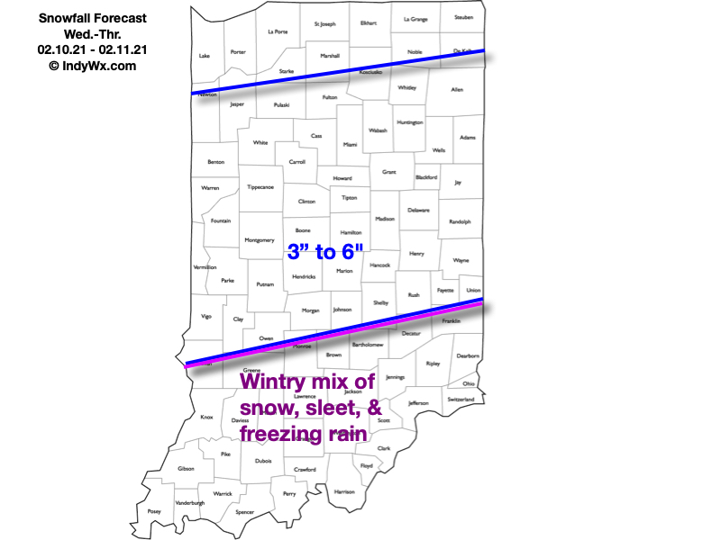
As the snow continues to add up, concern will mount around the issues that will likely come from a blowing and drifting perspective- especially as a fresh arctic intrusion arrives late week. If that wasn’t enough, additional “fun and games” are on the table for the upcoming weekend, followed by the coldest air so far this season (and in some cases in a couple of years).
Stay tuned…
Permanent link to this article: https://indywx.com/2021/02/08/multiple-snow-makers-cold-grows-more-bitter/
Feb 07
Updated 02.07.21 @ 9:02p
You must be logged in to view this content. Click Here to become a member of IndyWX.com for full access. Already a member of IndyWx.com All-Access? Log-in here.
Permanent link to this article: https://indywx.com/2021/02/07/video-snowpack-expands-in-the-week-ahead/
Feb 07
Updated: 02.07.21 @ 6:52p After a couple of times trying to cut a Client video discussion from the road, I’m running into issues uploading the content. I will be back…
You must be logged in to view this content. Click Here to become a member of IndyWX.com for full access. Already a member of IndyWx.com All-Access? Log-in here.
Permanent link to this article: https://indywx.com/2021/02/07/a-snowy-week-is-dialed-up-pattern-looks-cold-through-mid-feb/
Feb 07
Updated 02.07.21 @ 7:48a
It’s a frigid morning across central Indiana. From Indianapolis and points north we’re talking sub-zero cold. Wind chill values are plain out ugly this morning.
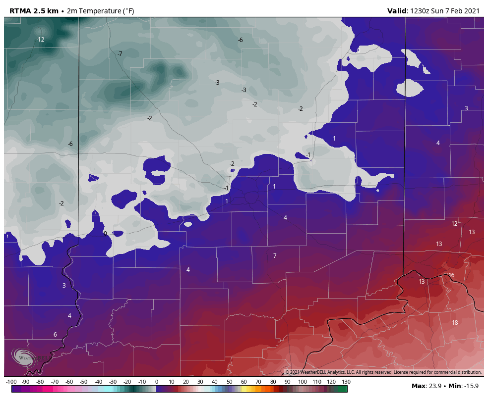
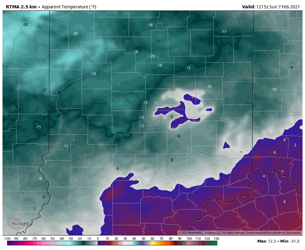
We’re tracking 4 snow makers in the upcoming 7 days and will have a complete breakdown on timing and amounts this evening with our client video update. Winter weather fan? This is a pattern to cherish over the upcoming few weeks. More on the long range will be included as well with this evening’s update.
Make it a great Sunday and we’ll talk with you this evening!
Permanent link to this article: https://indywx.com/2021/02/07/snow-begins-to-pile-up/