February 2021 archive

Weekly #AGwx And Severe Weather Outlook…

Updated 02.28.21 @ 7:25a

Headlines:

I. Heavy rain threat targets TN River Valley

II. Eastern, Southeastern regions cool late in the period

Overall, over the upcoming 7-day period, above normal temperatures are expected from the northern Plains into the Southeast, including OHV.
Precipitation is expected to run above normal across the Southeast, TN Valley, and lower OHV.
Rainfall should run between 0.75″ and 1.25″ for central IN over the upcoming 7-days.
There is a threat of severe weather today from the Ark-la-tex region into the western TN Valley.
Widespread significant drought continues across the West, especially Southwest/ Four-Corners region.

Forecast period: 02.28.21 through 03.07.21

The short-term will be dominated by a the wet (and stormy for some) time of things from the OH Valley, but more so centered in the TN River Valley. Eventually the associated frontal boundary will sweep into the Southeast region early in the work week before stalling out and serving as the focal point for additional storm systems mid and late week. The first of these systems will scoot from the southern Plains east into the Southeast in the Monday through Wednesday time period with additional opportunities for heavy rain and local severe weather. We’ll watch for another suppressed system late in the week that will likely take a similar route in the Thursday-Saturday timeframe.

From a central Indiana standpoint, best rain chances out of the entire period are in front of us now. Things should dry out considerably through the balance of the upcoming work week given the overall pattern.

Permanent link to this article: https://indywx.com/2021/02/28/weekly-agwx-and-severe-weather-outlook-21/

VIDEO: Analyzing Latest Short-Term Heavy Rain Trends; Guidance Trends Colder For The Eastern Seaboard Days 5-10…

Updated 02.27.21 @ 10:15a

You must be logged in to view this content. Click Here to become a member of IndyWX.com for full access.  Already a member of IndyWx.com All-Access?  Log-in here.

Permanent link to this article: https://indywx.com/2021/02/27/video-analyzing-latest-short-term-heavy-rain-trends-guidance-trends-colder-for-the-eastern-seaboard-days-5-10/

Heavy Rain Axis Shifts North…

Updated 02.27.21 @ 3a

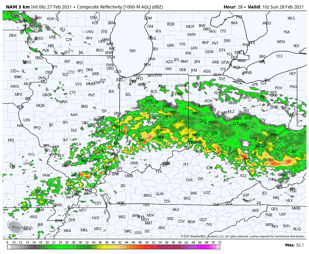
While we’re dealing with areas of light rain early this morning, most of our Saturday will be precipitation-free. That will all begin to chance during the overnight and predawn hours Sunday. Computer model guidance has begun to trend north with the heavy rain axis during this time frame. Southern portions of the state will still get in on the heavy rain show, but it now appears as if there will be a window for heavy rain across more of central Indiana in the 2a-9a window Sunday.

Forecast radar 5a Sunday
Rainfall totals through noon Sunday.

More later this morning in our video update.

Permanent link to this article: https://indywx.com/2021/02/27/heavy-rain-axis-shifts-north/

VIDEO: Heavy Rain Train Sets Up Along The KY/ IN Border This Weekend…

Updated 02.26.21 @ 7:55a

You must be logged in to view this content. Click Here to become a member of IndyWX.com for full access.  Already a member of IndyWx.com All-Access?  Log-in here.

Permanent link to this article: https://indywx.com/2021/02/26/video-heavy-rain-train-sets-up-along-the-ky-in-border-this-weekend/

Long Range Update: Time To Welcome In Meteorological Spring…

Updated 02.25.21 @ 9:27p

Meteorological spring is only a few days away. After a few weeks of significant winter weather, this week has trended much milder and gives hope to those longing for warmer and increasingly sunny days that spring is truly right around the corner. That said, long time Hoosiers know it’s rare we go from late February into “lock and hold” spring conditions without some sort of set-back.

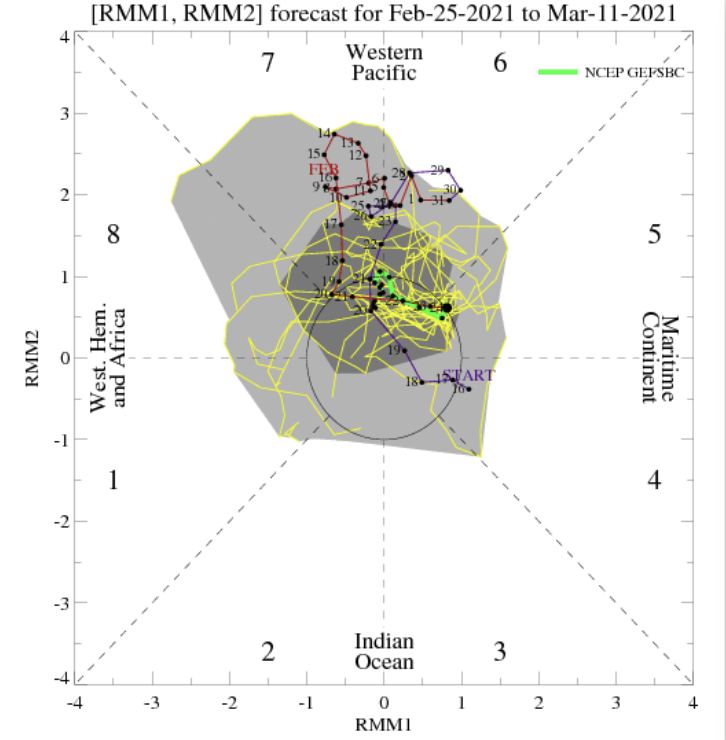
The MJO isn’t offering up much hope for serving as a basis of the longer range forecast over the next couple weeks (looks to remain mostly neutral throughout the period).

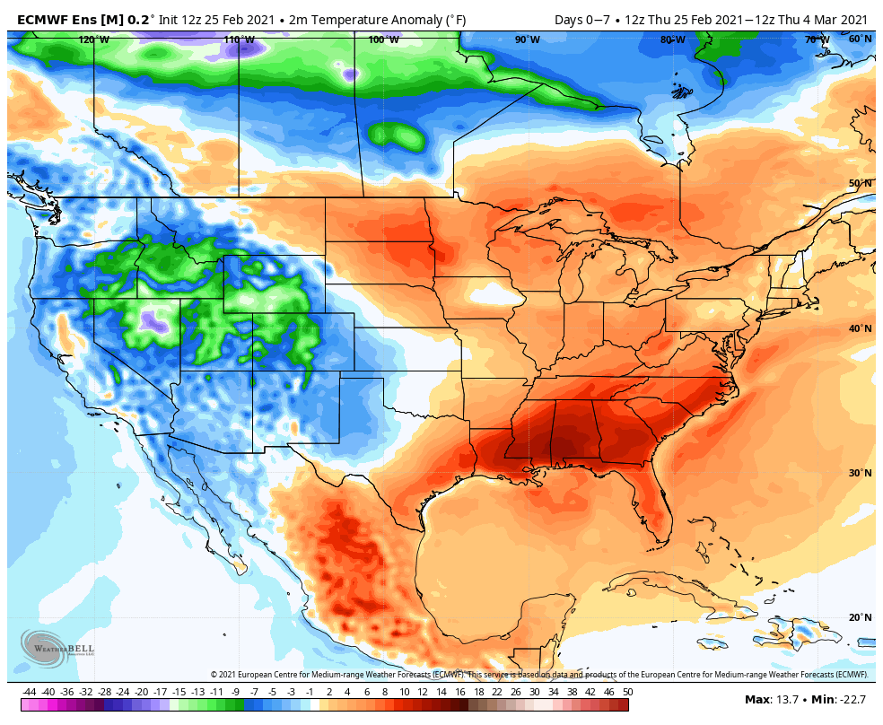
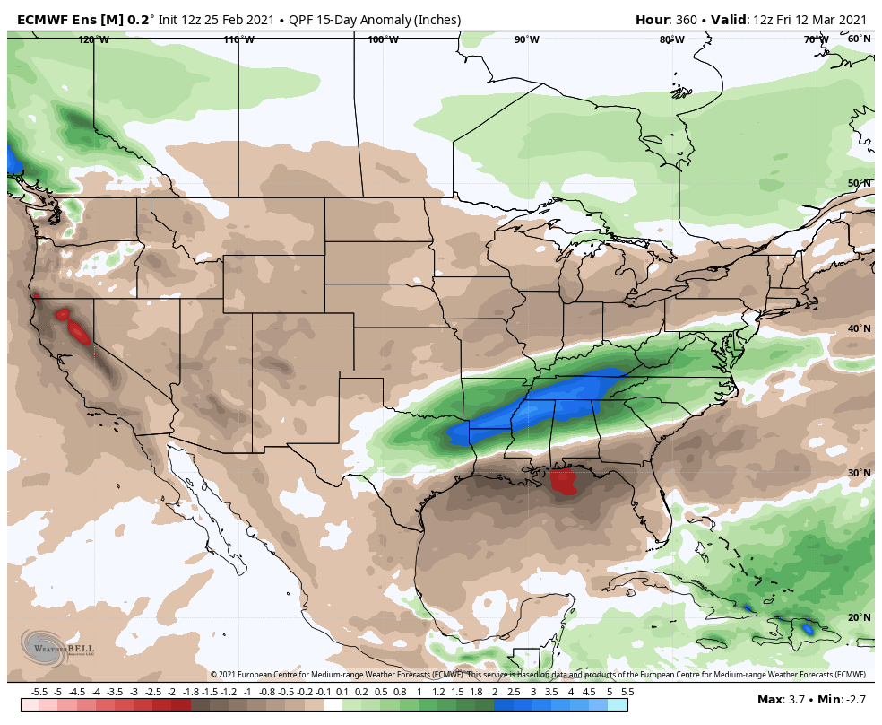
The latest teleconnections don’t favor any sort of long lasting cold over the next 2 weeks, relative to normal. Instead, we’re likely looking at a “transitional” period. While brief bouts of chilly conditions will likely present themselves from time to time, this shouldn’t have staying power- given the setup. Warmest anomalies should center themselves across the north-central with possible cooler conditions (relative to norm) along the eastern seaboard. The tag team effort here would favor wet (potentially even flooding issues) just to our south- TN Valley region. I’d argue for precipitation anomalies to run closer to seasonal norms across immediate central IN over the next 10-14 days.

We note the latest longer range ensemble data is trending in this direction.

Week 1
Week 2
15 day precipitation anomalies

We’ll want to keep close eyes on two items, in particular, moving forward: the NAO trends as well as MJO amplitude. From this distance, it sure appears as if meteorological spring will get off to a rather quiet note around these parts (first 10 days of March). Speaking of March, more on the complete monthly outlook this weekend.

Permanent link to this article: https://indywx.com/2021/02/25/long-range-update-time-to-welcome-in-meteorological-spring/

VIDEO: Sunshine Remains For Now; Heavy Rain Targets Far Southern IN This Weekend…

Updated 02.25.21 @ 7:14a

You must be logged in to view this content. Click Here to become a member of IndyWX.com for full access.  Already a member of IndyWx.com All-Access?  Log-in here.

Permanent link to this article: https://indywx.com/2021/02/25/video-sunshine-remains-for-now-heavy-rain-targets-far-southern-in-this-weekend/

VIDEO: Another Spring-Like Day Before We Trend Colder Tonight…

Updated 02.24.21 @ 8:20a

You must be logged in to view this content. Click Here to become a member of IndyWX.com for full access.  Already a member of IndyWx.com All-Access?  Log-in here.

Permanent link to this article: https://indywx.com/2021/02/24/video-another-spring-like-day-before-we-trend-colder-tonight/

VIDEO: The Spring “Fling” Is On…

Updated 02.23.21 @ 7:51a

You must be logged in to view this content. Click Here to become a member of IndyWX.com for full access.  Already a member of IndyWx.com All-Access?  Log-in here.

Permanent link to this article: https://indywx.com/2021/02/23/video-the-spring-fling-is-on/

02.22.21 Weather Bulletin: A Much Milder Week…

Updated 02.22.21 @ 8:15a

Gusty Out This Morning…Westerly winds are blowing at a good clip this morning, including gusts of 30-40 MPH. These will continue into the afternoon before diminishing. All in all, we’re looking at a much milder stretch of weather in the week ahead. Compared to the past couple of weeks, most days will be downright balmy. Sunshine will return tomorrow and remain with us through the day Friday. It continues to look like Wednesday night’s frontal passage will be an uneventful one.

As we look ahead to the weekend, shower chances return Saturday as a couple of systems team together. As of now, the northern and southern stream energy doesn’t look like it’ll phase until over the Northeast/ New England region. As such, this doesn’t look like a big deal here, but we’ll continue to keep an eye on things.

Averages: H: 43°/ L: 26° on the 22nd –> H: 45°/ L: 28° on the 28th

Permanent link to this article: https://indywx.com/2021/02/22/02-22-21-weather-bulletin-a-much-milder-week/

VIDEO: Slick Conditions Still Possible Tonight; “Hint” Of Spring In The Week Ahead…

Updated 02.21.21 @ 8:48a

You must be logged in to view this content. Click Here to become a member of IndyWX.com for full access.  Already a member of IndyWx.com All-Access?  Log-in here.

Permanent link to this article: https://indywx.com/2021/02/21/video-slick-conditions-still-possible-tonight-hint-of-spring-in-the-week-ahead/

IndyWx.com