
You must be logged in to view this content. Click Here to become a member of IndyWX.com for full access. Already a member of IndyWx.com All-Access? Log-in here.
2018 archive
Permanent link to this article: https://indywx.com/2018/11/19/cold-air-reinforcements-arrive-with-snow-showers/
Nov 18
Slushy Wet Snow Arrives Predawn…
A weak weather system will zip across the southern half of the state during the overnight into Monday morning. This will toss moisture into central Indiana towards midnight, continuing into the morning rush before scooting off to the east well before lunchtime. While this won’t be a big event, air will be just cold enough to allow the northern periphery of moisture to transition to wet snow after midnight into the predawn hours.

Areas along and just north of the I-70 corridor stand the best shot of awaking to a slushy wet snow of a dusting to around 1″.
Dry conditions quickly return during the mid to late morning hours and then we await cold air reinforcements and associated light snow showers Tuesday morning.
Winter’s off to a fast start, heh? Speaking of that, our annual Winter Outlook will be posted Black Friday. Here’s a hint, you may want to put a snow shovel/ blower on the shopping list this year…
Permanent link to this article: https://indywx.com/2018/11/18/slushy-wet-snow-arrives-predawn/
Nov 18
Looking At The Thanksgiving Week Forecast And On Towards Early December…
You must be logged in to view this content. Click Here to become a member of IndyWX.com for full access. Already a member of IndyWx.com All-Access? Log-in here.
Permanent link to this article: https://indywx.com/2018/11/18/looking-at-the-thanksgiving-week-forecast-and-on-towards-early-december/
Nov 16
Weak Weekend System; Dry Stretch For Thanksgiving…
You must be logged in to view this content. Click Here to become a member of IndyWX.com for full access. Already a member of IndyWx.com All-Access? Log-in here.
Permanent link to this article: https://indywx.com/2018/11/16/weak-weekend-system-dry-stretch-for-thanksgiving/
Nov 15
Waking Up To An Ice Storm And Looking At The Rest Of The Month…
I. A mixture of sleet and freezing rain transitioned mostly to freezing rain during the overnight and many across central Indiana are waking up to a significant “glaze” this morning (.2″ to .3″). Power outages are growing and travel is tricky in spots. If you don’t have to travel, please remain indoors.
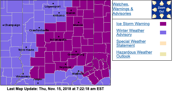
An Ice Storm Warning remains in place until 12p, followed by a Winter Weather Advisory until 7p.
After a “lull” in the precipitation, a burst of light snow will develop this afternoon into the early evening hours before dry conditions return tonight.
 II. As we look ahead, our next weather system will scoot into the region over the weekend. This will be a weak event and we only expect a light mixture of snow and rain Saturday evening.
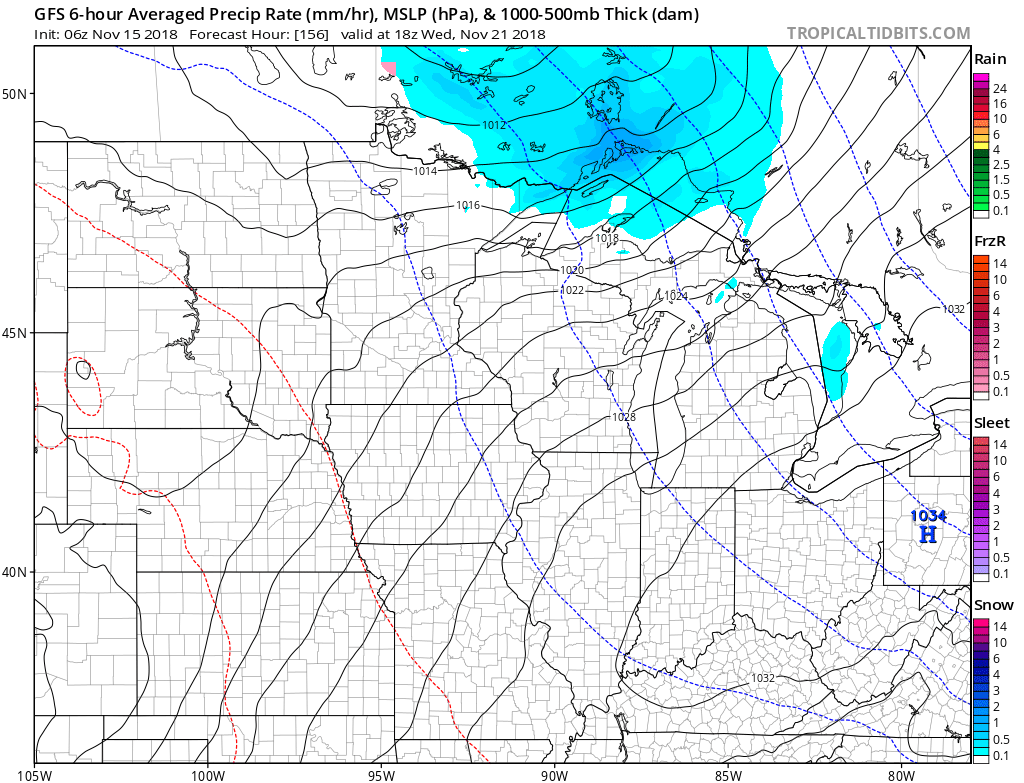
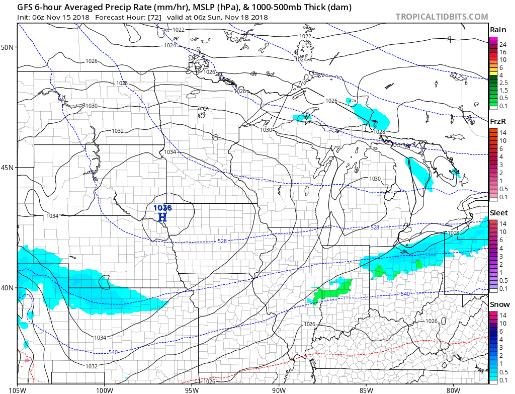 III. The balance of Thanksgiving week looks rather quiet, but chilly, thanks to high pressure. The stretch of below to well below normal temperatures will continue, overall.
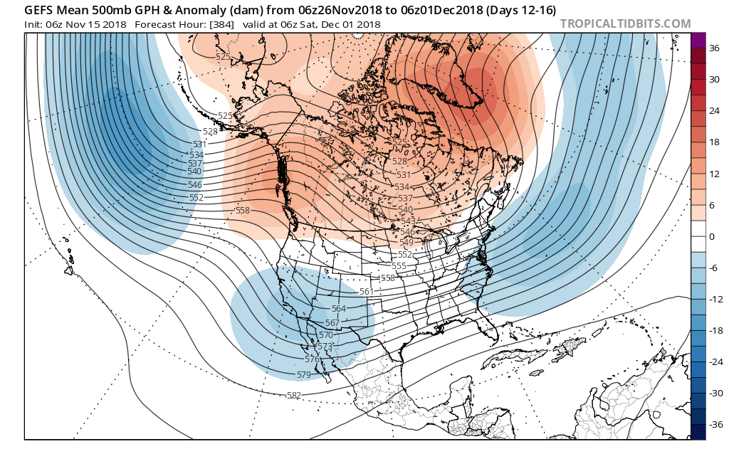
 IV. As we look ahead, the pattern sure looks cold and stormy as we open December. On that note, the majority of data continues to trend colder for the month of December, as a whole, and with high latitude blocking in place, we’d expect to see an active storm track across the country. If you like it cold and active for the holidays, you just might be in luck this year… More on that later!
Permanent link to this article: https://indywx.com/2018/11/15/waking-up-to-an-ice-storm-and-looking-at-the-rest-of-the-month/
Nov 14
Video Update On The Wintry Conditions That Are Inbound…
You must be logged in to view this content. Click Here to become a member of IndyWX.com for full access. Already a member of IndyWx.com All-Access? Log-in here.
Permanent link to this article: https://indywx.com/2018/11/14/video-update-on-the-wintry-conditions-that-are-inbound/
Nov 14
First Winter Storm System Of The Season…
You must be logged in to view this content. Click Here to become a member of IndyWX.com for full access. Already a member of IndyWx.com All-Access? Log-in here.
Permanent link to this article: https://indywx.com/2018/11/14/first-winter-storm-system-of-the-season/
Nov 13
Tuesday Evening Rambles: Notes On Wednesday Night-Thursday…
After reviewing the latest data, we wanted to take a moment to provide a couple of take-aways on the storm system that will impact the region tomorrow night and Thursday.…
You must be logged in to view this content. Click Here to become a member of IndyWX.com for full access. Already a member of IndyWx.com All-Access? Log-in here.
Permanent link to this article: https://indywx.com/2018/11/13/tuesday-evening-rambles-notes-on-wednesday-night-thursday/
Nov 13
Complex Thursday Event; Looking Ahead To Thanksgiving Week…
A complicated storm system will result in a mixed bag of precipitation for some and mostly wet snow for others Thursday. We need another 24 hours to “firm up” the…
You must be logged in to view this content. Click Here to become a member of IndyWX.com for full access. Already a member of IndyWx.com All-Access? Log-in here.
Permanent link to this article: https://indywx.com/2018/11/13/complex-thursday-event-looking-ahead-to-thanksgiving-week/
Nov 12
Looking At A Busy (Wintry) Week Ahead…
I. A weak weather system will result in light precipitation (mostly snow) overspreading central and northern portions of the state later this evening into the overnight. Moisture looks less and less impressive with each and every model run, but we’ll still go with a slushy coating to less than 1″ for the city, itself with a general 1″ to 2″ of wet snow for communities off to the north of the city. Additionally, a lake effect snow band should get going Tuesday morning and this band may make it south into east-central Indiana in a weakened state.

Light snow will overspread the region tonight. Image courtesy of Weathermodels.com.
 II. Another push of unseasonably cold air will pour south into the region behind this storm system and set the stage for a potentially interesting time of things when a new storm system approaches a bit later in the week…
 III. A very complex storm system will impact the area Thursday. While there are many details that are yet to be worked out, someone across the mid-south into the Ohio Valley will likely get a “plowable” snow out of this event. Initially, available cold air will be marginal, but with an expected strong upper level low, this storm system is likely to “manufacture” its’ own cold air and result in a swath of heavy, wet snow to the north and northwest of where the upper low tracks. Stay tuned.
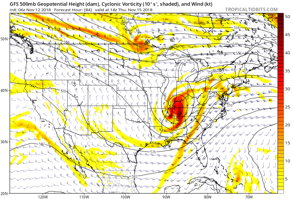
 Behind this storm, you guessed it- cold air will reinforce itself across the region heading into next weekend!
Permanent link to this article: https://indywx.com/2018/11/12/looking-at-a-busy-wintry-week-ahead/