2018 archive

Wet Close To 2018…

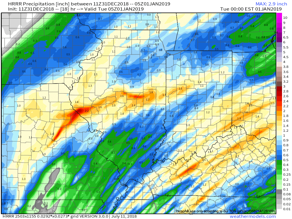
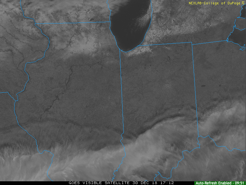
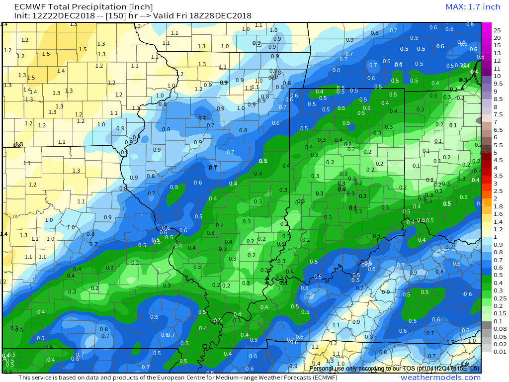
IND has already recorded over half an inch in the rain gauge this morning and there’s more where that came from between now and tonight. Steady rain will be replaced with scattered downpours late morning to around the lunchtime hour before widespread rain and embedded thunder returns early to mid afternoon.  Most can expect to tack on an additional half inch to inch of rain today and the latest HRRR sees this as well.

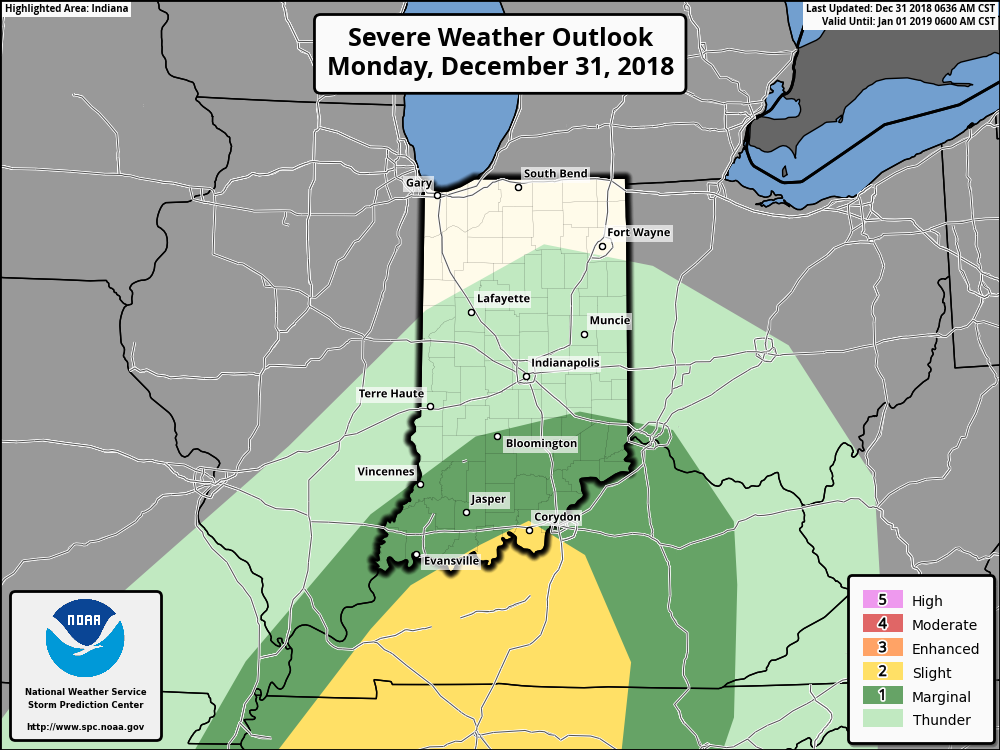
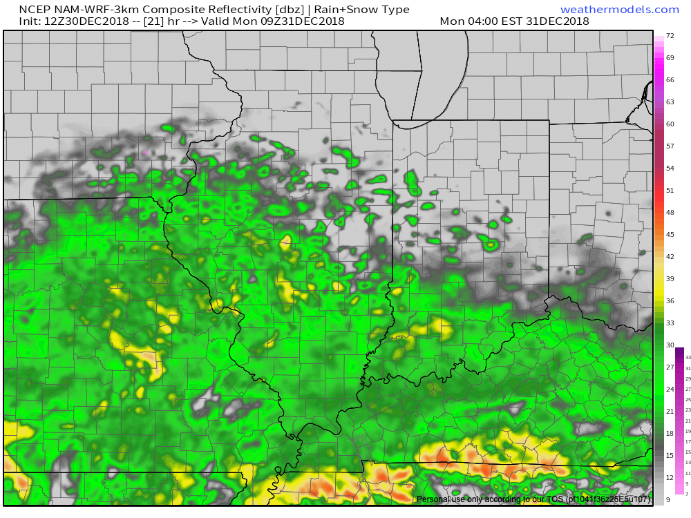
We’re also still monitoring the potential of strong to severe thunderstorms across southern portions of the state.  The Storm Prediction Center now includes far southern Indiana in a Slight Risk for severe weather today.  The primary concerns remain strong, damaging winds with a line of thunderstorms that may develop between 2p and 4p.  If your travels take you south towards Louisville today remain weather-aware.

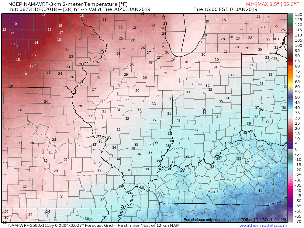
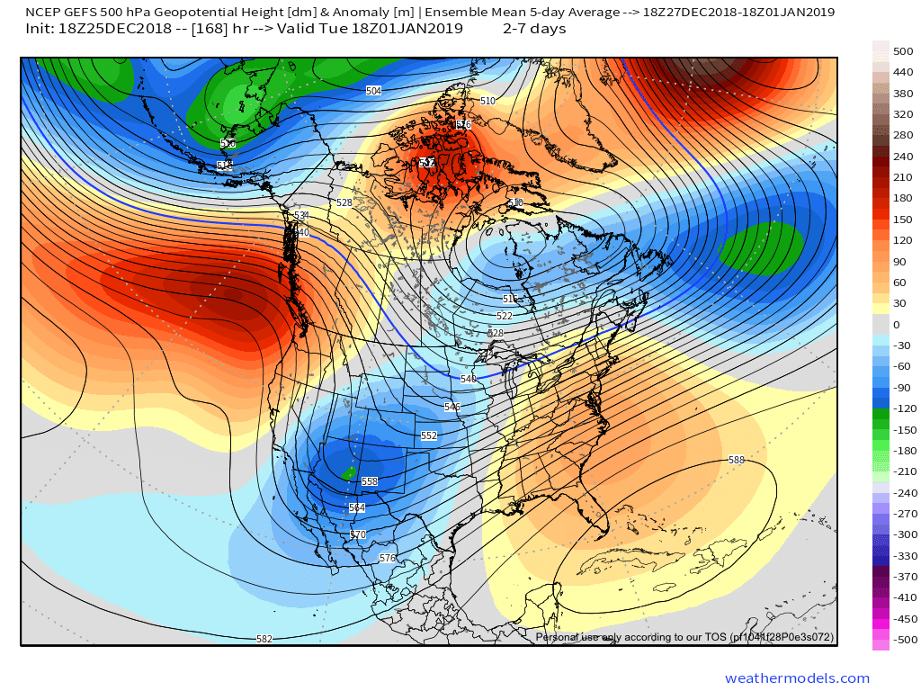
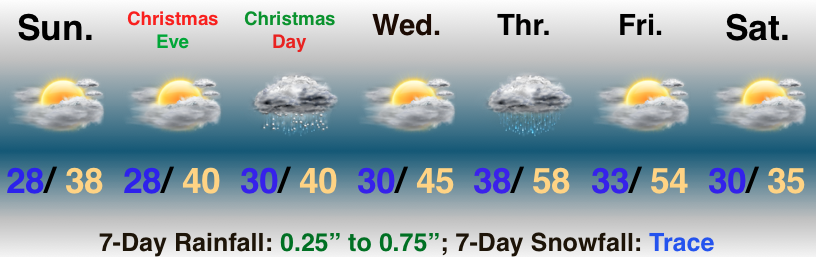
Temperatures will run 25° to 30° colder New Year’s Day and a couple of scattered snow showers may fly- especially across the favored snowbelt areas to our north.

Have a happy and safe New Year’s Eve, friends!

Permanent link to this article: https://indywx.com/2018/12/31/wet-close-to-2018/

Heavy Rain (And Thunder Downstate) Arrives For New Year’s Eve…

We’re enjoying pleasant conditions this afternoon with filtered sunshine and temperatures that should top out in the upper 30s to lower 40s later on.  Enjoy it, as a big rain event gets underway for New Year’s Eve.

This afternoon’s visible satellite shows sunshine dominating across the northern half of #INwx.

Clouds will increase tonight and rain won’t be too far behind.  We think wet weather builds into central Indiana before sunrise Monday (likely between 4a to 6a) and periods of heavy rain are still expected late morning into the afternoon and evening hours.

Rain will arrive into the city itself between 4a and 5a Monday. 

We continue to monitor the prospects of a skinny line of strong thunderstorms that may impact southern Indiana Monday afternoon and evening.  If your travels take you south to Louisville for NYE plans, this is something to monitor.  Widespread severe weather isn’t expected, but strong winds are possible if this line materializes.

Timing out prospects for a skinny line of storms to impact southern #INwx Monday afternoon. Best idea as of now will come between 2p and 4p.

This storm system will have a true tropical connection.  Precipitable water values will be quite “juicy” for late December and plenty capable of producing locally heavy totals.  Widespread 1″ to 1.5″ can be expected, but a few area rain gauges will likely see higher amounts.

Colder air will whip in here late tomorrow night and help lingering moisture fall as scattered snow showers New Year’s Day.  More later on the potential of wintry “mischief” later in the week…
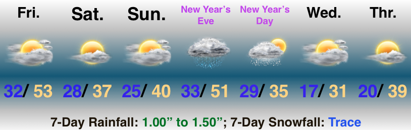
Permanent link to this article: https://indywx.com/2018/12/30/heavy-rain-and-thunder-downstate-arrives-for-new-years-eve/

Wet Close To 2018 On Deck…

You must be logged in to view this content. Click Here to become a member of IndyWX.com for full access.  Already a member of IndyWx.com All-Access?  Log-in here.

Permanent link to this article: https://indywx.com/2018/12/29/wet-close-to-2018-on-deck/

Turning Colder Today; Another Rain Storm As We Close 2018…

Highlights:

  • Falling temperatures today
  • Chilly, but sunshine this weekend
  • Wet weather returns New Year’s Eve

Spring This Morning; Winter Tonight…Temperatures are starting off on a downright balmy note for late-December, but that “spring fling” will come to a crashing end later this afternoon and evening as temperatures fall.  It’ll be a dry day, but blustery.  Jackets will be required by the afternoon on.

Sunshine remains in place this weekend before another big rain maker arrives on the scene as we close out the year.  Locally heavy rain can be expected Monday.  Much colder air will plunge in behind this particular storm system and left over moisture will fall as scattered snow showers New Year’s Day.

Permanent link to this article: https://indywx.com/2018/12/28/turning-colder-today-another-rain-storm-as-we-close-2018/

Tracking 2 Rain Events; Cold Open to 2019…

Highlights:

  • Wet with a few t-storms
  • Dry weekend
  • Wet then cold to open 2019

Rain Gear Needed…The pattern is transitioning from the predominantly mild stretch of the past couple weeks to one that will turn much colder as we move into January.  In between?  Active times, as we’re tracking two big storm systems between now and NYE.

The initial push of moisture has reached the I-65 corridor as of this forecast issuance early Thursday morning.  Periods of rain will continue through a good chunk of the day and we may even throw in some thunder into the mix later this evening- especially across southern portions of the state.  The other big story today?  Strong and gusty southerly winds.

Rain will end later tonight with dry, blustery, and colder times returning as we close the week.  Highs tomorrow will come predawn before falling through the day.  Dry and seasonable times will continue as we move through the last weekend of 2018.

A new storm system promises a return of wet times as we get set to ring in the new year.  Definitely plan on having the rain gear handy as you head out to those New Year’s Eve parties Monday.  Heavy rain is possible at times.  As the area of low pressure tracks northeast, it’ll swing a cold front through here Monday night and we’ll turn sharply colder with snow showers on New Year’s Day, itself.

Permanent link to this article: https://indywx.com/2018/12/27/tracking-2-rain-events-cold-open-to-2019/

Rain Arrives Tomorrow…

You must be logged in to view this content. Click Here to become a member of IndyWX.com for full access.  Already a member of IndyWx.com All-Access?  Log-in here.

Permanent link to this article: https://indywx.com/2018/12/26/rain-arrives-tomorrow/

Looking at the Holiday Week and Ahead to January…

Tomorrow will be a rather uneventful weather day across central Indiana, but things will begin to change as we head into Thursday.

An area of low pressure will track out of the central Plains into the Great Lakes by Friday. The end result will be increasing coverage of showers Thursday afternoon and perhaps even a rumble of thunder Thursday evening.

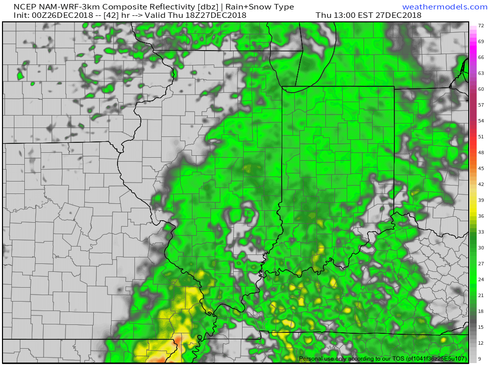
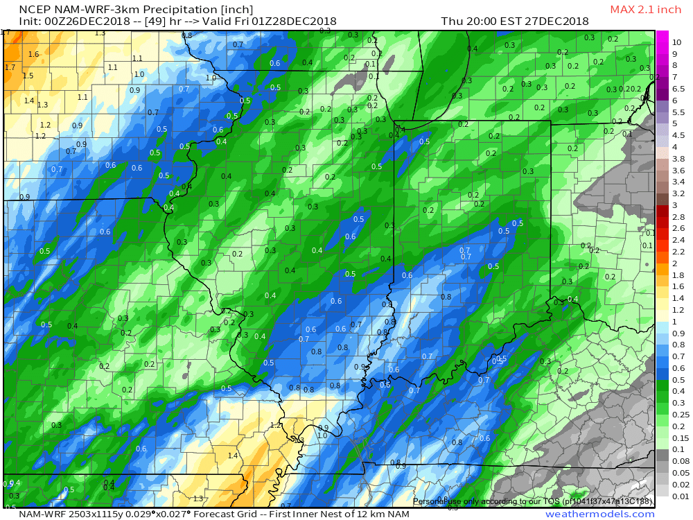
Most of the concentrated rain should come to an end around dark Thursday. By that time we forecast a general 1/2″ to 1″ to fall in area rain gauges.
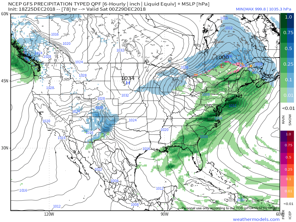
More seasonable air will blow in here behind the storm system and we’ll have to keep an eye on energy “attacking” from behind over the weekend. With colder weather in place, snow is possible next weekend.

Looking ahead, a combination of ingredients appears to be coming together to create a rather significant transition in the pattern as we head into January. Note the developing positive PNA…

This will result in more sustained below normal temperatures making a return early January to our neck of the woods…

Additionally, it also appears an active storm track will continue. While impossible to say this far in advance, prospects for above average snowfall (average is 8.6″) appear likely through the month of January.

Permanent link to this article: https://indywx.com/2018/12/25/looking-at-the-holiday-week-and-ahead-to-january/

Quiet Now; Weak System For Christmas…

Highlights:

  • Quiet weather for Christmas travel
  • Weak system Christmas Day
  • Stronger storm mid week

Chilly, But Rather Quiet…We’ll have some clouds around, but we should stay generally free of precipitation through Christmas Eve.  A weak weather system will provide some light snow or a wintry mix Christmas morning before ending as light rain or drizzle.  This won’t be a big deal, but will provide a festive time of things as you wake up to see what Santa brought.

A stronger (and warmer) storm will deliver rain Thursday along with gusty southerly winds.  Dry and colder weather will return as we get set to close out the week.

Permanent link to this article: https://indywx.com/2018/12/23/quiet-now-weak-system-for-christmas/

Pre-Christmas Weather Rambles…

I. While we certainly aren’t talking about significant weather events between now and Christmas Day, there will be a couple of impulses of upper level energy that may be just strong enough to produce snow showers and flurries at times.  We’re tracking (2) weak disturbances that stand a chance to get a couple of snow showers going Sunday evening and again Christmas Day.  The one on Christmas, itself, will be a bit stronger and may have a shield of more organized precipitation- likely that would start as wet snow before transitioning to rain before ending.

II. A much stronger storm system will wrap up to our northwest Wednesday night and Thursday.  We’ll notice an increasingly strong southerly breeze during this time period and rain will be on the increase as we progress through the day Thursday.  The trade-off?  Highs between 55° and 60° to close the week- though those temperatures may actually come Thursday evening before cooler air begins to slip in here during the day Friday.

As things stand now, both the GFS and European models, courtesy of Weathermodels.com, aren’t overly excited on rainfall amounts with this storm system, but I think they’ll trend wetter as time goes on.  We’ll continue to forecast amounts between 0.50″ and 1″.

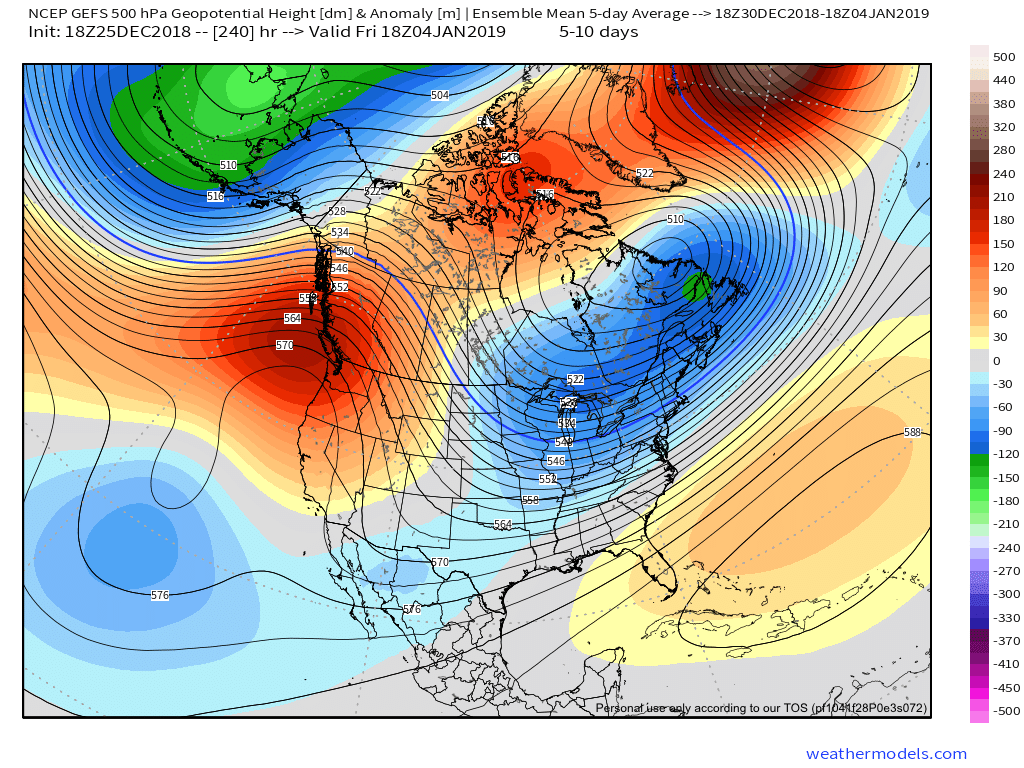
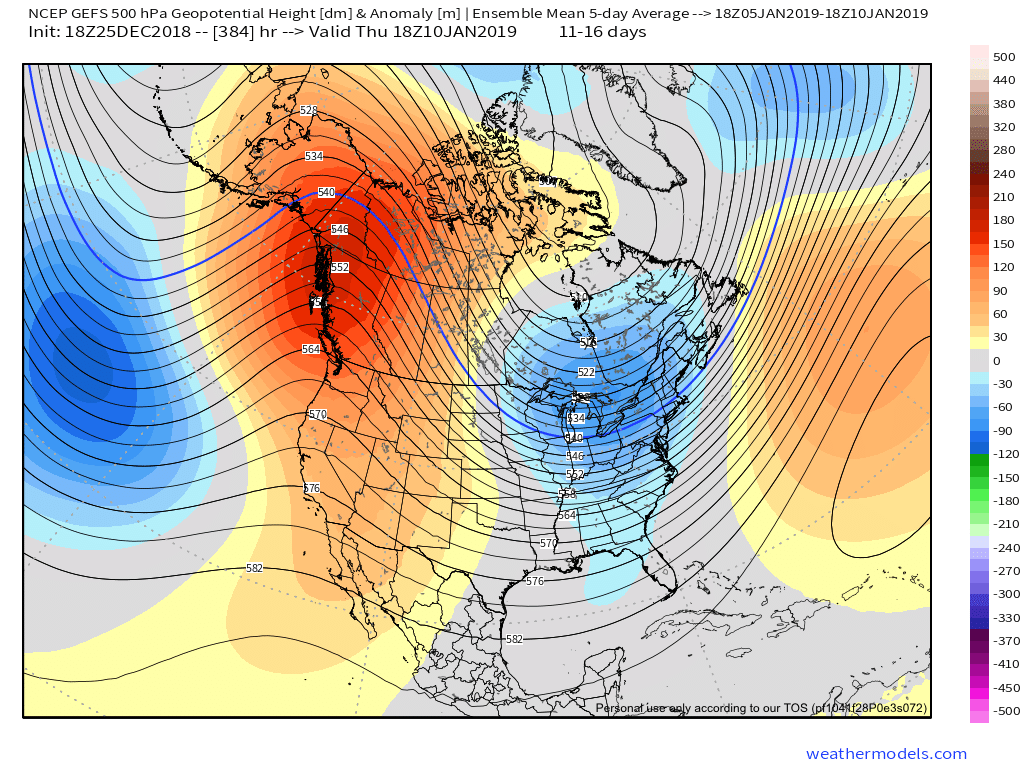
III. All attention is squarely focused on a significant pattern change that takes shape as we head into the new year.  As mentioned in previous posts and discussions, the transition is likely to be a stormy one, but it’s far too early to talk precipitation types.  A combination of ingredients appears to be aligning to create a colder than normal (and potentially significantly so) pattern at the traditionally coldest time of year (mid-Jan).

In the more immediate term, we note the latest GEFS showcases a classic “horse shoe” block that will favor a wintry regime across the east to open the new year- thanks to Tropicaltidbits.com.

Permanent link to this article: https://indywx.com/2018/12/22/pre-christmas-weather-rambles/

Christmas Flakes?

Highlights:

  • Tracking weak weather systems leading up to Christmas
  • Mild close to next week
  • Pattern change looms

Couple Of Weak Systems…We don’t expect any sort of significant weather impacts, locally, between now and the big Christmas holiday.  With that said, there will be a couple of weak impulses of energy that will zip through the region, offering up the potential of a couple of light snow showers and flurries Sunday evening and again Christmas Day.

Quiet conditions will return Wednesday, but we’ll notice an increase in cloud cover- especially during the afternoon and evening.  This will be a hint of things to come Thursday.  Though it’ll be wet, at least we’ll have unseasonably mild conditions in place.  Some south-central Indiana communities may even crack the 60° mark!  A cold front will settle south through the region Friday, eventually allowing a return of more seasonable conditions Friday night.

As we look ahead, there are growing indications that a significant pattern change looms as we usher in the new year.  It may not be a bad idea to stock up that wood pile…

Permanent link to this article: https://indywx.com/2018/12/22/christmas-flakes/

IndyWx.com