April 2018 archive

Spring Fling…

An approaching storm system will help pull spring-like air into the region for at least a couple days later this week.  Highs will go into the lower 70s Thursday and middle to upper 70s Friday.  After a winter that’s certainly overstaying his welcome, that will feel mighty nice!

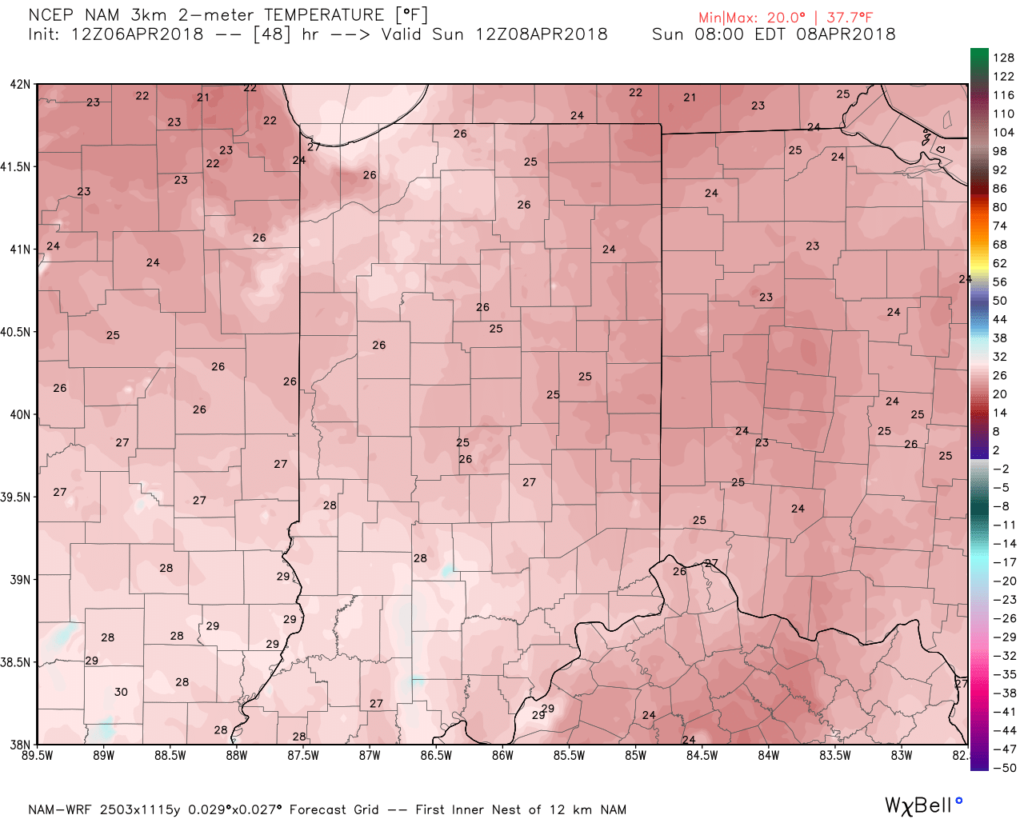
Highs will zip into the mid and upper 70s Friday!

Unfortunately, the nice spring-like feel won’t last.  A cold front will sweep through the state Saturday with showers and thunderstorms late Friday night into the daytime Saturday, followed by a dramatic wind shift and much colder air for the second half of the weekend behind the frontal passage.

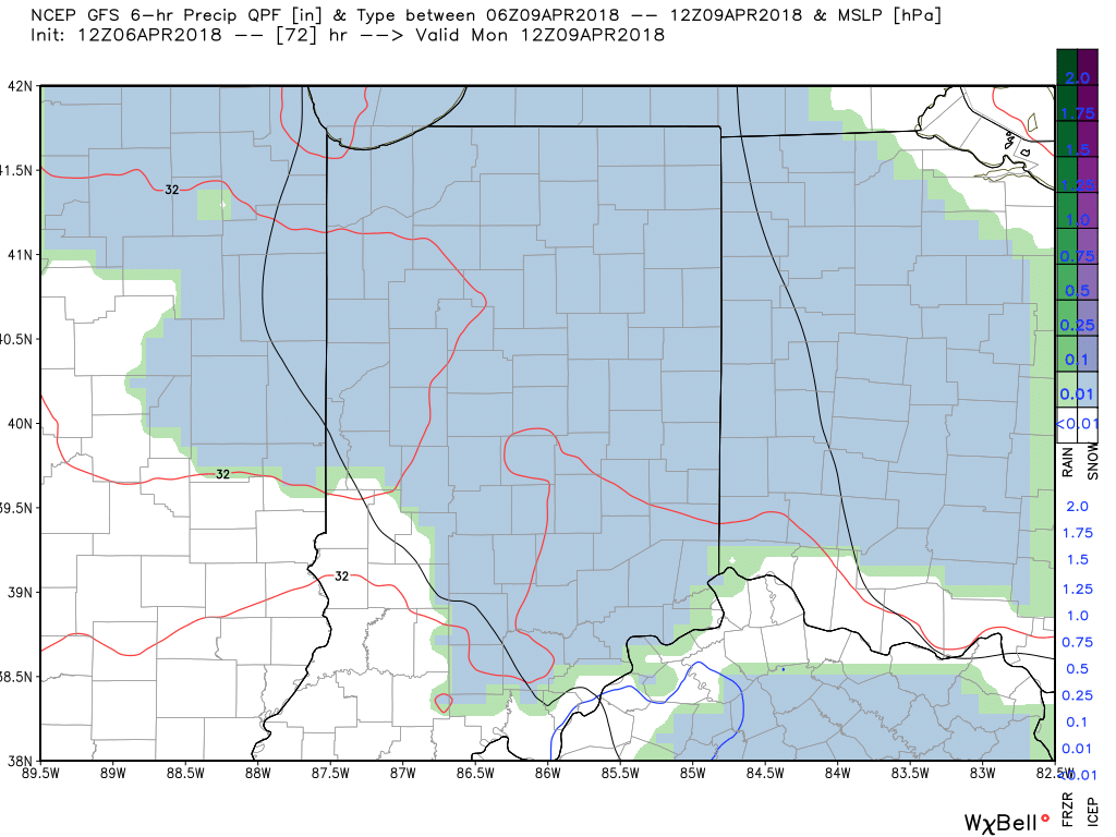
As upper level energy moves overhead, mixed rain and snow showers will fall early next week.

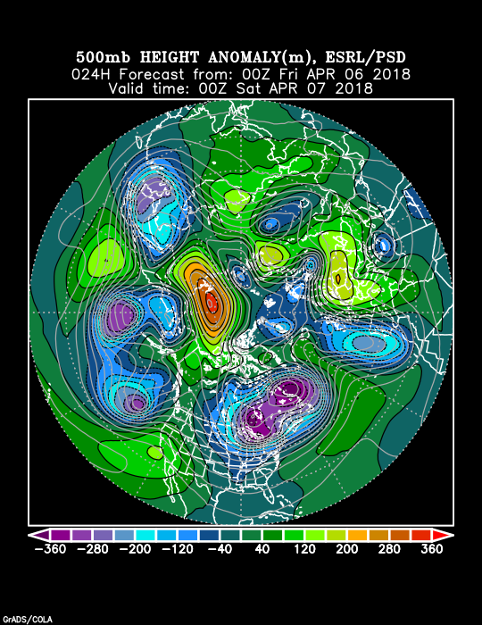
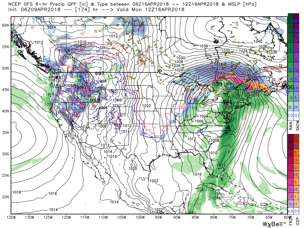
Longer term, the negative NAO will continue to lead to prolonged colder than average temperatures.  At this point, we think this pattern will run at least through the remainder of April.

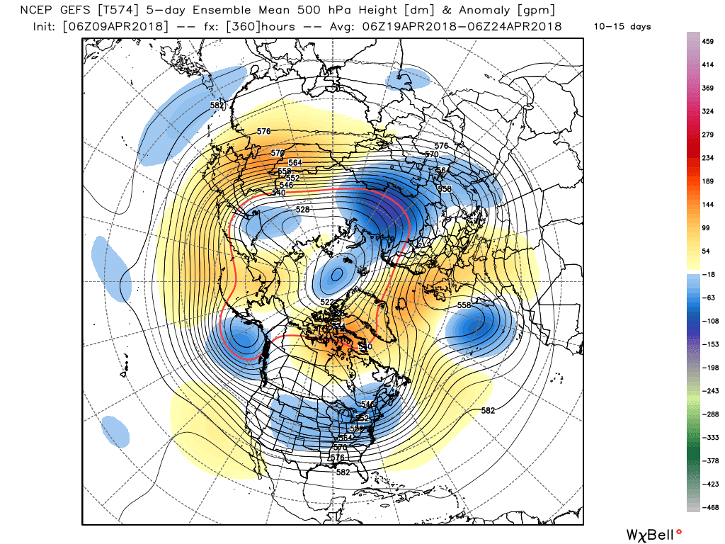
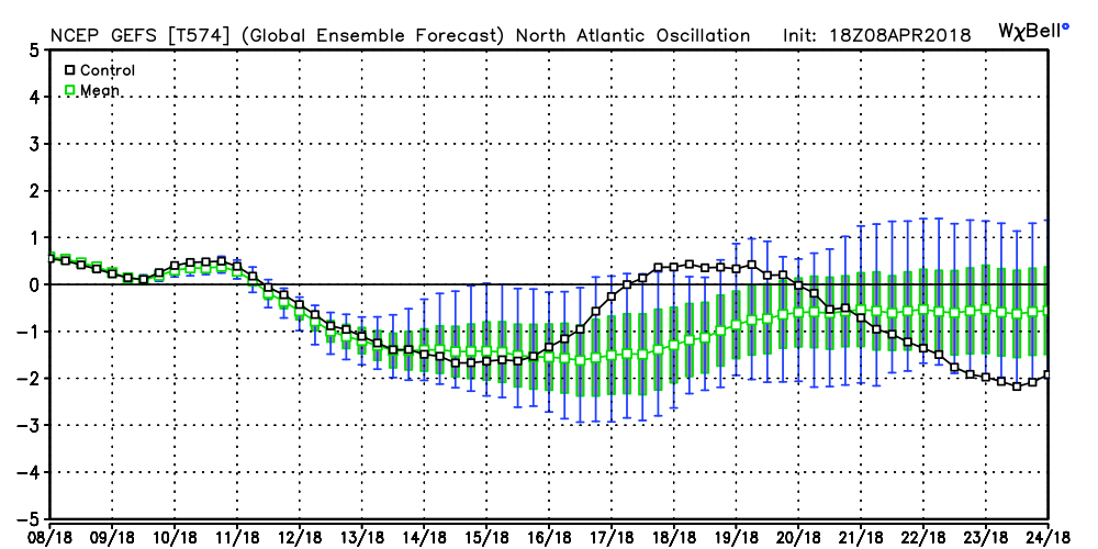
The end result?  You know it: a persistent eastern trough and associated colder than average feel…

Permanent link to this article: https://indywx.com/2018/04/09/spring-fling-2/

More April Snow Ahead…

Our Sunday is beginning on a cold, but dry note.  Despite starting in the lower and middle 20s, at least we have the sunshine to greet us out the door!

The clouds we see to our west are associated with a storm system that will deliver another round of accumulating April snow to central Indiana late tonight and early Monday.

We should hold onto the sunshine into the afternoon hours before those clouds begin to increase, eventually lowering and thickening through the evening hours.

Timing: Snow should begin to impact western portions of the state around 10p, or so, before advancing east and reaching the city, itself, around 11p.

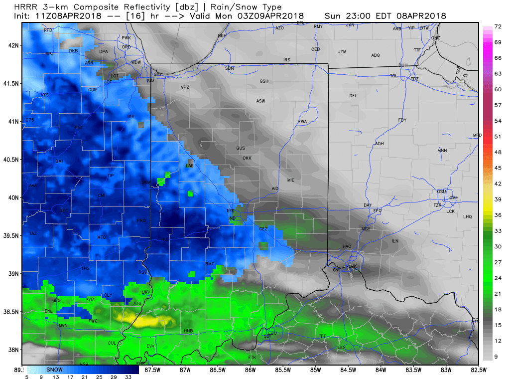
Snow will then overspread the rest of the state during the overnight and come down at a moderate clip at times, especially for the western half of the state.

Snow will continue through the predawn hours Monday before tapering to snow showers closer to the Monday morning rush.

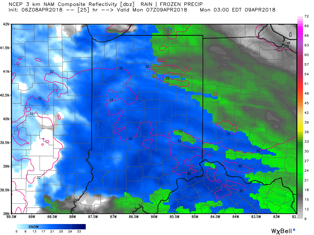
While temperatures will hover around freezing through the majority of the event, the recent unseasonably cold conditions will allow the possibility of a few slick spots on area roadways during the overnight and predawn hours.  Take it slow if you plan to be out and about early Monday morning.

Accumulation:  Most of central Indiana can expect around an inch of wet snow by sunrise Monday, but there will be a few folks (especially west of the I-65 corridor) where a couple of inches of snow will fall.

As we look ahead into the upcoming work week, the big story will be a push of spring-like warmth late week (lower 70s Thursday and mid to upper 70s Friday).  With that said, the warmth won’t hold as a negative NAO continues to dominate.  The end result will be a quick return to unseasonably cold conditions this time next week.  That cold will then take us through the balance of the rest of the month…

Permanent link to this article: https://indywx.com/2018/04/08/more-april-snow-ahead/

VIDEO: Weekend Ends With More April Snow…

The weekend will end with more April snow. As we look ahead deeper into next week, a transient, but significant, push of warmth will arrive Thursday and Friday.

You must be logged in to view this content. Click Here to become a member of IndyWX.com for full access.  Already a member of IndyWx.com All-Access?  Log-in here.

Permanent link to this article: https://indywx.com/2018/04/07/video-weekend-ends-with-more-april-snow/

Weekend Cold Is Something To Behold…

An anomalous pattern will result in unseasonably cold air this weekend.  A cold front will blow through the state this evening and while a period of snow will accompany the FROPA (frontal passage), the bigger deal will be the weekend cold.  Keep in mind, averages for the weekend include lows of 40° and highs in the lower 60s.

An anomalous weather pattern will grip the region this weekend.

The pattern will deliver a feel more like mid-February (when highs average in the lower 40s and lows fall into middle 20s), as opposed to early-April.

Most of Saturday will be spent in the 30s, and the coldest morning should come Sunday with widespread lows in the middle 20s.

Highs around 40 would be “normal” for mid-Feb and a good 20+ degrees below average.

Lows Sunday morning will be downright bitter by April standards.

And if the unseasonably cold air isn’t enough, a disturbance will “attack” the cold Sunday night leading to a mix of rain and snow that should transition to mostly snow Sunday night.  While this won’t be a big deal, just the fact that we’re talking about snow yet again is getting old for most folks.  Unfortunately, the pattern looks to remain colder than average through late April, despite a brief break late next week.

Permanent link to this article: https://indywx.com/2018/04/06/weekend-cold-is-something-to-behold/

VIDEO: Briefly Warmer Late Next Week, But Cold Pattern Remains Overall…

You must be logged in to view this content. Click Here to become a member of IndyWX.com for full access.  Already a member of IndyWx.com All-Access?  Log-in here.

Permanent link to this article: https://indywx.com/2018/04/06/video-briefly-warmer-late-next-week-but-cold-pattern-remains-overall/

VIDEO: Cold Pattern Remains For Now; Window For Warmth In The 8-10 Day…

You must be logged in to view this content. Click Here to become a member of IndyWX.com for full access.  Already a member of IndyWx.com All-Access?  Log-in here.

Permanent link to this article: https://indywx.com/2018/04/05/video-cold-pattern-remains-for-now-window-for-warmth-in-the-8-10-day/

Records? We’ve Got Records, And Looking Ahead…

Meteorological spring began March 1st (though you wouldn’t know it with all of the cold and snow lately).  Snow dominated the headlines in March with nearly a foot that fell.  Cold also was a story as temperatures ran significantly below normal.  Check out these impressive stats, courtesy of the Indianapolis National Weather Service:

  • The 10.2″ of snow that fell at Indianapolis on the 24th set the daily snowfall record and 2nd snowiest March day ever.
  • The 11.6″ of snow at Indianapolis resulted in March 2018 going down as the 6th snowiest March on record.
  • Temperatures ran 3.3° below average.

Though we’re only a few days into the month of April, the fourth month of the year is already trying to “out do” March.  Sleep has been few and far between here in the good ole forecast office with such an active start to the month.  From the heaviest Easter snow on record to setting the wettest day in April ever and widespread flooding, we’ve had it all in just the first (3) days!

  • Indianapolis recorded 3.9″ of rain on the 3rd- good for the daily rainfall record and greatest amount of rain within any April day on record.
  • Easter snow: though some places received more (3.2″ at Whitestown and up to 6″ of snow at Lafayette and Frankfort), Indianapolis accumulated 2.1″ which set a record for snowiest Easter and snowiest April 1st.

At one time what looked like another snow-starved snow season is now getting oh so much closer to “average,” with the late season rally.  As the saying goes, “it’s never over until it’s over!”  In Whitestown, we’re now over 30″ on the season!  Indianapolis is up to 22.7″ on the season and only 3″ below average.

Looking ahead, the upcoming couple weeks should continue to promote an active pattern.  Temperatures should follow the colder than normal theme and precipitation should run above average.  For the snow, we’re not done with that yet, either!  Speaking of snow, we’re tracking additional opportunities for snowfall this weekend and again early next week…  Hang in there, spring will get here eventually…

More of a winter than spring feel this week. Image courtesy of Weatherbell.com.

Colder than average temperatures continue in the 6-10 day.

Additional opportunities of accumulating snow are present over the next couple weeks.

An active pattern remains…

Permanent link to this article: https://indywx.com/2018/04/04/records-weve-got-records-and-looking-ahead/

VIDEO: One Day Of Spring Before We Go Back To Winter…

You must be logged in to view this content. Click Here to become a member of IndyWX.com for full access.  Already a member of IndyWx.com All-Access?  Log-in here.

Permanent link to this article: https://indywx.com/2018/04/03/video-one-day-of-spring-before-we-go-back-to-winter/

Another Busy Week…

I. On the heels of a record-setting Easter snow event, attention will turn to showers (by this evening) and even the potential of gusty thunderstorms (Tuesday).

Forecast radar 10p.

Forecast radar 5a Tuesday.

Best chance of the possibility of a strong to severe thunderstorm will lie within the southern half of the state, primarily south of the I-70 corridor.  Greatest threats are large hail and damaging straight line winds.

All of us stand the chance of a thunderstorm as the cold front sweeps through the state Tuesday night.

Forecast radar 8p Tuesday.

II.  Much colder air will rush back into Indiana Tuesday night and the air will grow cold enough to allow lingering precipitation to transition to snow showers Wednesday morning.  Don’t expect any accumulation this go around.

III.  Our next focus is on the prospects of late week/ weekend snow.  Models will continue to struggle with the finite details over the next few days.  I’m not so sure the suppressed look displayed currently is the correct one.  Let’s remember, this time last week models were taking our Easter storm well to our south.  We’ll keep a close eye on things over the next few days.

IV.  Regardless of whether we get additional snow down or not, a first-class late season arctic blast will drill south this weekend.  This will be cold enough to keep temperatures in the 30s for highs Friday and Saturday.  Brutal stuff for early-April when average highs are around 60…

Permanent link to this article: https://indywx.com/2018/04/02/another-busy-week/

VIDEO: Heavy Wet Snow Arrives Before Sunset…

You must be logged in to view this content. Click Here to become a member of IndyWX.com for full access.  Already a member of IndyWx.com All-Access?  Log-in here.

Permanent link to this article: https://indywx.com/2018/04/01/video-heavy-wet-snow-arrives-before-sunset/

IndyWx.com