 Highlights:
- Damp, chilly Sunday
- Milder week ahead
- Spring-preview late next week
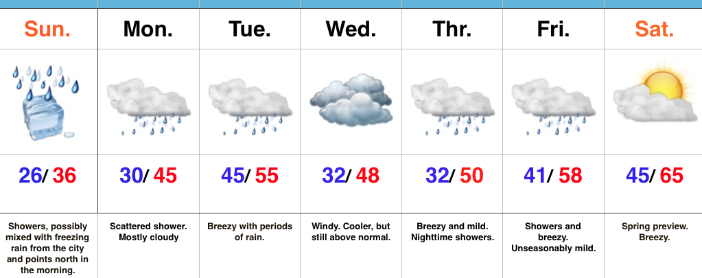
Improvements Coming…Most of tonight will feature dry conditions along with temperatures settling back below freezing (most of central IN will fall into the middle to upper 20s). Another surge of light precipitation will arrive Sunday morning into the afternoon and this could begin as a period of freezing rain from the city and points north. Similar to today, we don’t expect any major problems from the freezing rain and all of the region should warm above freezing during the afternoon.
While Monday could feature a quick-hitting shower at any given time, more widespread steady rain will push into central Indiana during the day Tuesday, along with breezy conditions. Those breezy southwest winds will help give temperatures a boost into the middle 50s for afternoon highs.
We’ll shift that southwest wind around to the northwest Wednesday and this will help push cooler air into the state for mid week. Despite the cooler feel, we’ll remain well above average with breezy conditions. (Average highs in central Indiana are in the middle 30s this time of year).
The big news for the latter portion of the forecast period will be a true spring-like feel developing as we rumble into the weekend. In fact, temperatures will surge well into the 60s next Saturday. Modeling isn’t in total agreement on rain chances with a moist southwest flow in place. We’ll take the “optimistic” route at this time and forecast a dry Saturday, understanding that we’ll have to maintain a close eye on things.
Quick heads up, longer term data continues to suggest we’ll flip into a much colder and stormy pattern as we wrap up January and head into February. Winter is far from over…
Upcoming 7-Day Precipitation Forecast:
- Snowfall: 0.00″
- Rainfall: 0.50″ – 1.00″
