 Highlights:
- Another bitter day
- Moderating temperatures ahead
- Late week ice threat looms
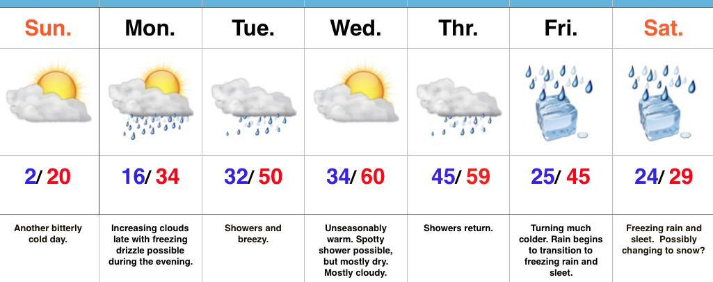
Bitter Cold Gives Way To Moderating Temperatures…The first half of the forecast period is easy, but we caution big time headaches loom and details are far from etched in stone once to the second half of this forecast period.
First thing’s first and that’s today. Look for a continuation of bitterly cold air, but slow moderation will be noted this afternoon: Not AS bitter and lighter winds. We may even crack the 20 degree mark! I know, break out the swim suits, right?! This moderating trend is setting the tone for a more significant jump in the mercury later in the week. Before a “taste of spring” arrives, we’ll have to deal with a brief opportunity for freezing drizzle Monday evening. Temperatures will zoom to around 50 Tuesday and around 60 for mid week. Showers will be with us off and on- focused on Tuesday and Thursday for most widespread coverage.
Then comes the “fun.” A strong, sprawling arctic high will push south into the northern Plains Friday. At the same time, “resistance” from the southeast ridge (that can be thanked for the spring-like feel here Wednesday and Thursday) will result in the arctic front only slowly being able to push south. Ripples of energy, or waves of low pressure, will move along the arctic boundary and result in periods of widespread precipitation Friday into the weekend. As the cold, dense arctic air oozes south, we have concern for icing- freezing rain and sleet Friday into Saturday. Depending on how things evolve, this may continue into Sunday, as well. If you have travel plans this weekend, please keep a close eye on the developments in the forecast from Friday on. Stay tuned.
Upcoming 7-Day Precipitation Forecast:
Snowfall: 1.00″
Rainfall: 1.50″ – 2.00″
