
You must be logged in to view this content. Click Here to become a member of IndyWX.com for full access. Already a member of IndyWx.com All-Access? Log-in here.
2016 archive
Permanent link to this article: https://indywx.com/2016/11/22/video-thanksgiving-weather-interesting-open-to-december/
Nov 21
Busy And Chilly Thanksgiving Week…
 Highlights:
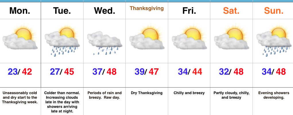
- Unseasonably cold, but dry to kick off Thanksgiving week
- Next system blows in with showers Tuesday night
- Dry Thanksgiving
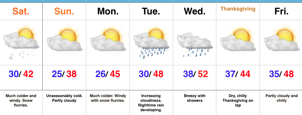
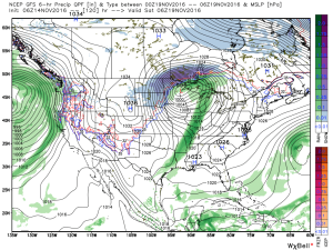
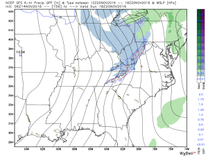
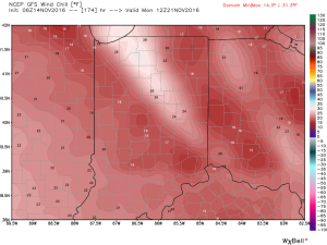
Active Week…Some folks across central Indiana are waking up to temperatures in the upper 10s this morning (looking at you Crawfordsville) and most everyone else is being greeted by lower to middle 20s out the door! It’s a very cold start to the day. Thankfully, dry conditions will remain today and through the daytime Tuesday. Clouds will be on the increase Tuesday, but we should hold off on rain until late at night. Unfortunately, the big travel day Wednesday will feature periods of rain and blustery, chilly conditions. It’ll be a raw day.
We’ll dry things out for Thanksgiving, itself, along with seasonable temperatures. Reinforcing chilly air will blow into town Black Friday and our next storm system of interest will arrive Sunday. Most of the day Sunday will feature dry conditions before rain arrives on the scene by evening.
Upcoming 7-Day Precipitation Forecast:
- Snowfall: 0.00″
- Rainfall: 1.00″-1.50″
Permanent link to this article: https://indywx.com/2016/11/21/busy-and-chilly-thanksgiving-week/
Nov 20
Snowy; Increasingly Cold December Expected…
The 2016-2017 IndyWx.com Winter Outlook was posted on October 30th. If you haven’t had an opportunity to see it, you can here. Right out of the gate, we remain bullish on the prospects of a snowy holiday stretch this year, including above average snowfall for the month of December (average December snowfall at IND is 6.9″).
We continue to undergo that “step-down” process within the pattern, but there are growing signals that suggest the pattern takes on a very “blocky look” as we rumble into December. When we talk about a blocking pattern in this instance, we’re specifically talking about high-latitude blocking. Essentially this is when high pressure sets up in the high latitude regions (Greenland or northern Canada, for example). Textbook blocky patterns feature high pressure that sustains itself and is very persistent, leading to a “log-jam” of sorts in the weather pattern, and playing a pivotal role in locking cold, stormy weather in for lengthy periods of time across the Lower 48. Many times this is a “feedback” type scenario, meaning the early period of blocking patterns initially turns stormy and then grows progressively colder as the snowpack is laid down further and further south.
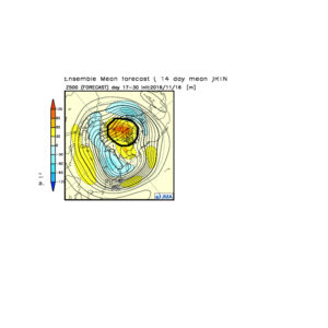
When we look at the medium-range and longer-term model data, we note the blocky pattern developing as we wrap up November and rumble into December. The European, Canadian, and GFS ensemble data all shows the stormy look evolving.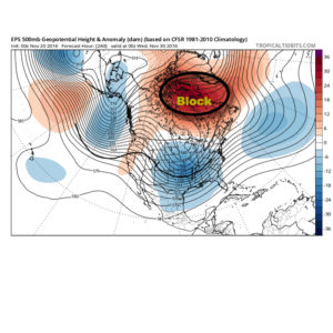
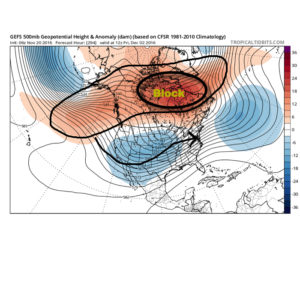
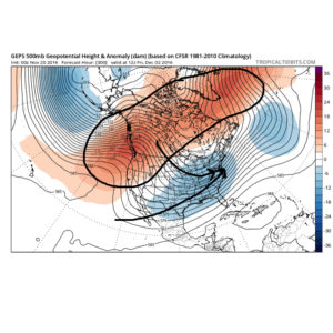 The Weeklies also show this pattern in the longer-term. While we can’t show the European data here (due to licensing), we can show the JMAs. Again, note the high-latitude blocking.
 Active times are ahead as a busy storm track develops. Perhaps the scene for many will look a little something like this as we push into the Christmas season…
 In the meantime, gas up the snow blower and sharpen the snow shovel. If our idea is correct, a snowier than average December will come out of this blocky pattern.
Permanent link to this article: https://indywx.com/2016/11/20/snowy-increasingly-cold-december-expected/
Nov 19
First Flakes Of The Season…
 Highlights:
- Colder pattern taking hold
- First flakes of the season
- Wet, windy system on the big travel day
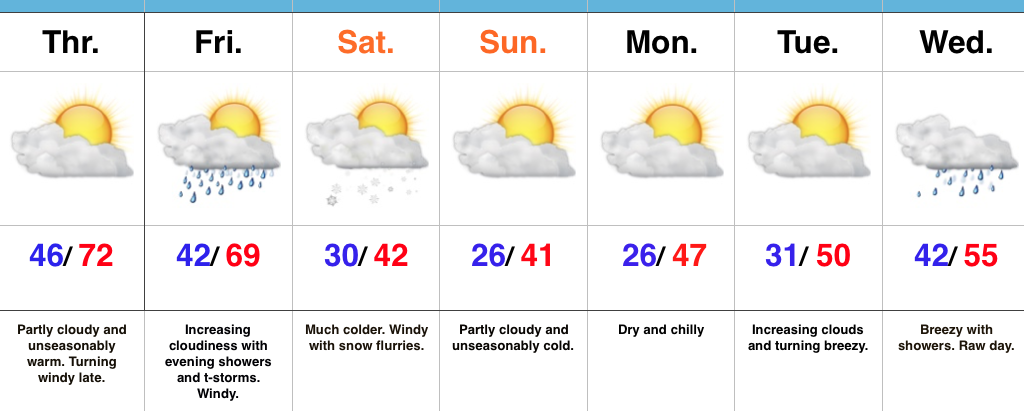
Pull Out Those Heavier Coats…Last night’s cold front hit with authority and will likely be looked back on as the “game changer” between the warm, quiet fall we enjoyed and colder, more active times ahead. Today is much colder with snow flurries and scattered snow showers. Gusty NW winds will feature wind chills in the 20s through the daytime before falling into the 10s tonight.
Calm, cold weather will continue into early next week before our next storm system blows into town Tuesday evening. Clouds will increase through the day Tuesday and rain will arrive at night. The big travel day before Thanksgiving looks blustery and wet with showers (especially during the first half of the day). We’ll get the system out of here to allow for a dry, chilly Thanksgiving.
Looking ahead, another system of “interest” is on deck late next weekend or early the following week. Timing and details are far from etched in stone with this being 7+ days out, but the potential is there for this to feature a wintry component…
Upcoming Precipitation Forecast:
- Snowfall: Trace
- Rainfall: 1.00″
Permanent link to this article: https://indywx.com/2016/11/19/first-flakes-of-the-season/
Nov 18
VIDEO: Stormy By Evening; Much Colder This Weekend…
You must be logged in to view this content. Click Here to become a member of IndyWX.com for full access. Already a member of IndyWx.com All-Access? Log-in here.
Permanent link to this article: https://indywx.com/2016/11/18/video-stormy-by-evening-much-colder-this-weekend/
Nov 17
Warm Today; Cold Changes Await…
 Highlights:
- Breezy and warm close to the work week
- T-storms Friday evening
- Cold weekend with Saturday flurries
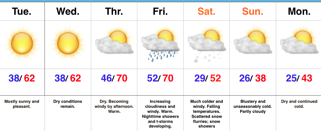
Changeable Weather…If you don’t find a way to get outside today something is wrong. Let the boss know IndyWx.com gave you permission to spend an extended lunch outdoors today. 🙂 Sunny skies and unseasonably warm temperatures will be with us through the day, along with an increasingly gusty afternoon wind.
Clouds increase Friday and showers develop Friday evening. A couple of stronger thunderstorms are also possible as the front sweeps through the state. While we’re not forecasting a widespread severe wind potential, one or two strong and gusty storms are possible. The front will hit like a wall Friday night and feature an abrupt wind shift and plummeting temperatures. That high Saturday in the lower 40s will be predawn as most of the day will be spent in the 30s with gusty winds and snow flurries. Steadier snow squalls will be found across north and northeast IN.
Dry, chilly weather will be with us for the remainder of the weekend, continuing into the beginning of the Thanksgiving week ahead. Our next storm system is slated for the big travel day Wednesday. Expect showers and gusty winds followed by colder weather for Thanksgiving, itself.
Upcoming 7-Day Precipitation Forecast:
- Snowfall: Trace
- Rainfall: 0.50″ – 0.75″
Permanent link to this article: https://indywx.com/2016/11/17/warm-today-cold-changes-await/
Nov 16
VIDEO: Unseasonably Warm Thursday-Friday; First Flakes Of The Season This Weekend…
You must be logged in to view this content. Click Here to become a member of IndyWX.com for full access. Already a member of IndyWx.com All-Access? Log-in here.
Permanent link to this article: https://indywx.com/2016/11/16/video-unseasonably-warm-thursday-friday-first-flakes-of-the-season-this-weekend/
Nov 15
Big Changes Loom…
 Highlights:
- Mostly sunny and pleasant into mid week
- Gusty SW winds usher in near-record warmth to close the work week
- Friday night showers and storms
- Coldest air and first flakes of the season ahead
Brace For Changes…The short-term remains very quiet and pleasant. If you haven’t already, we suggest knocking out that remaining yard work for the season, or get a jump on the outdoor Christmas lights! (Rude changes loom).
Winds will turn gusty out of the southwest Thursday, especially by afternoon. These strong and gusty SW winds will top 40 MPH Thursday into Friday, but also serve to help give temperatures a boost. Highs both Thursday and Friday will be near record levels.
We should remain dry through the daytime Friday, but a band of showers and embedded thunder will rumble through the state Friday night as a strong cold front passes through. Behind the cold front, expect an abrupt wind shift to the northwest and falling temperatures through the day Saturday. Heavier jackets and coats will be required as wind chills in the 20s fall into the teens Saturday night into Sunday morning. Left-over, “backlash” moisture will fall in the form of flurries and scattered light snow showers. Further north, light accumulations of snow are possible across northern IN snowbelt communities.
Cold, dry weather will continue into early next week. Looking further ahead, another storm system looms around Thanksgiving.
Upcoming 7-Day Precipitation Forecast:
- Snowfall: 0.00″
- Rainfall: 0.25″-0.50″
Permanent link to this article: https://indywx.com/2016/11/15/big-changes-loom/
Nov 14
Taste Of Winter This Weekend…
A rather pleasant, benign week of weather will transition to a rude feel by the weekend.
A cold front will sweep through the state Saturday morning and will help the season’s first blast of true, winter-like air plunge southward over the weekend, into early next week. Ahead of the cold front, a band of showers and perhaps a clap of thunder will track east. As of now, rainfall totals don’t look particularly impressive (0.10″-0.25″).
Shower chances will increase Friday evening. Courtesy of weatherbell.com
Ahead of the front, winds will gust out of the southwest Thursday afternoon and Friday (in the 30-40 MPH range), but will shift around to the northwest Saturday (same 30-40 MPH potential) and drive a much colder air mass southeast. Temperatures will fall through the day Saturday and temperatures will grow cold enough Saturday evening into Sunday to allow “backlash” moisture to fall as scattered snow showers and snow flurries. Further north, in the snowbelt regions, heavier lake-generated snow bands and squalls will develop over the second half of the weekend.
The season’s first true lake effect snow outbreak will occur this weekend. Courtesy of weatherbell.com
Wind chills will fall into the teens Sunday night into Monday morning.
Longer term, data continues to suggest we continue to transition, overall, towards a colder and stormy pattern in the targeted Thanksgiving to Christmas period. More on that later this week…
Permanent link to this article: https://indywx.com/2016/11/14/taste-of-winter-this-weekend/
Nov 13
Frosty Mornings; Late Week Storm System…
 Highlights:
- Dry stretch of weather remains
- Late week storm system offers up rain; t-storm chances
- Much colder next weekend
Frosty Mornings To Start The Week…High pressure will dominate our weather pattern to open the new week. As such, skies will remain mostly sunny and temperatures will be very pleasant. Monday morning will feature the third morning in a row with sub-freezing air. Expect another frosty start to the day, including outlying neighborhoods into the 20s yet again.
Looking ahead, our weather will remain rather uneventful until Thursday. Dry conditions will remain, but southwest winds will become increasingly gusty by the afternoon. This is in advance of an approaching storm system that will deliver showers, and perhaps a clap of thunder, Friday evening. Timing will have to be fine tuned as we progress through the week. Behind the boundary, much colder air will pour into the region on gusty northwest winds next weekend. In fact, the air will grow cold enough to potentially lead to scattered snow showers Saturday night into Sunday in the left over “back lash” moisture.
Upcoming 7-Day Precipitation Forecast:
- Snowfall: 0.00″
- Rainfall: 0.25″ – 0.50″
Permanent link to this article: https://indywx.com/2016/11/13/frosty-mornings-late-week-storm-system/