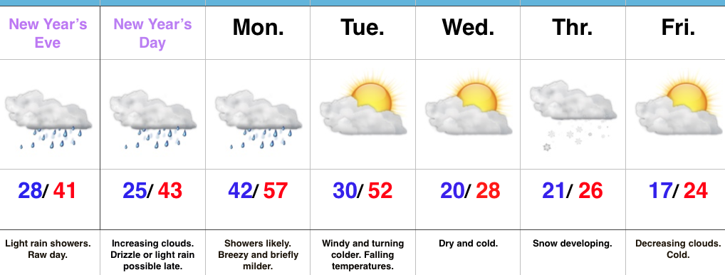
2016 archive

Busy 7-Day To Usher In 2017…

screen-shot-2016-12-30-at-7-18-25-pmHighlights:

  • Raw New Year’s Eve
  • Briefly milder Monday with showers
  • Snow prospects mid week

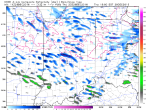
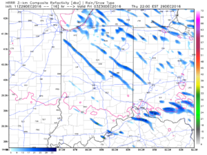
Busy Times…Clouds will increase late tonight and give way to showers during the daytime New Year’s Eve.  Most of this shower activity will be light, but you’ll want to carry the rain gear with you as you leave for New Year’s Eve parties and celebrations throughout central IN.  Once to the nighttime hours, showers should diminish and most of the nighttime should feature rain-free conditions, along with colder temperatures.

New Year’s Day may start out with some sunshine, but clouds will increase through the day and drizzle or light rain is possible by evening.  Low pressure will track northeast from the central Plains into the upper Mid West Monday.  This will place Indiana in a relatively warm southwest flow.  Periods of showers can be expected through the day, along with breezy conditions.  An accompanying cold front will sweep through the state early Tuesday morning and shut rain chances off, shift winds to the northwest, and lead to falling temperatures.

Wednesday will be a day in between storm systems.  Cold high pressure will settle into the Ohio Valley and supply unseasonably chilly temperatures, but with sunshine.

Our next storm system will approach Thursday.  Clouds will increase Wednesday night and give way to an expanding snow shield during the day Thursday.  We still have a few days to look at things, but from this distance, the potential is present for an impactful wintry event across a widespread portion of the Ohio Valley, including central Indiana.  Stay tuned.  Fresh arctic air will move in to put a close on yet another short work week.

Upcoming 7-Day Precipitation Forecast:

Snowfall: 1″ – 3″

Rainfall:  0.75″ – 1.25″

Permanent link to this article: https://indywx.com/2016/12/30/busy-7-day-to-usher-in-2017/

Shift Back To A Cold Pattern Awaits; What About Winter Storm Potential?

December-to-date is running colder than normal (to the tune of 2.2 degrees at IND), but the past (7) days has seen a flip in the frigid 1st half of the month.

December temperature anomalies, courtesy of Weatherbell.com.

December temperature anomalies, courtesy of Weatherbell.com.

Temperature anomalies the last 7 days. Courtesy of Weatherbell.com.

Temperature anomalies the last 7 days. Courtesy of Weatherbell.com.

The “relaxation” is temporary.  Modeling continues to advertise the recent “thaw” will give way to increasingly bitter times as we get deeper into the New Year.  By New Year’s Day we note the positive heights continuing to establish themselves across Alaska and Greenland (cold and stormy signal).  We also note the southeast ridge present, though to a lesser degree than over the past week.

jan1
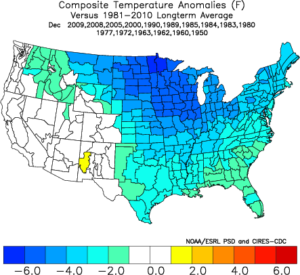
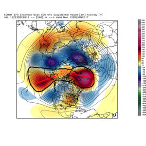
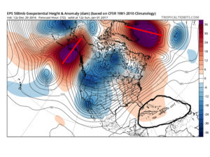
By Day (10), the cold pattern is well established over the Lower 48.  This is a coast-to-coast cold signal (heart of the cold centered over the west and central) depicted by the European ensemble, along with other modeling.

day10

ecmwf-ens_t850amean_namer_6
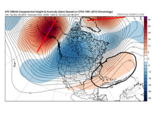
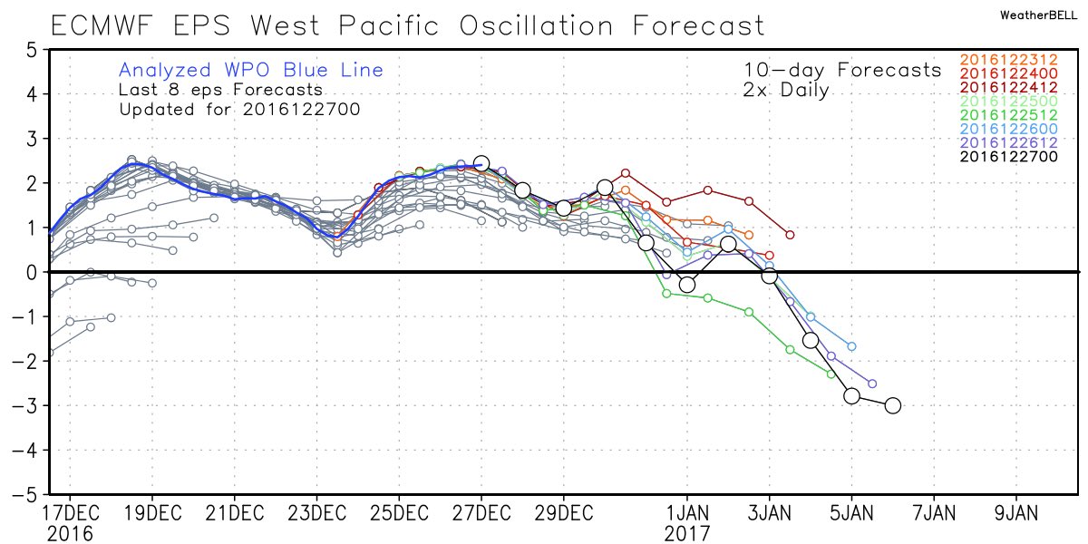
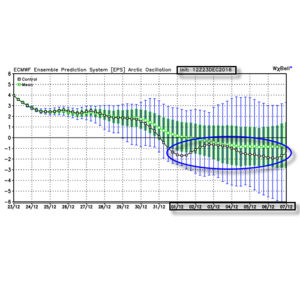
Teleconnections support a cold pattern returning.

epowpo122916

aonao122916

pna
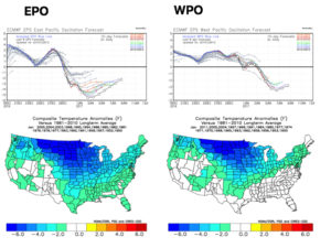
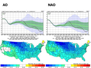
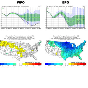
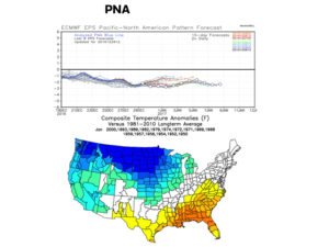
The agreement amongst teleconnections is nice to see and ups confidence in the overall direction of where this pattern is heading in regards to colder than average times looming.  The negative PNA correlates nicely with the SE ridge that continues to make itself heard from time to time over the next few weeks.  It should also be noted that the phases of the Arctic Oscillation (AO) and North Atlantic Oscillation (NAO) become more of a factor for mid and late winter.

As far as storminess goes, we’ll have to handle those as they come.  The overall pattern screams towards the idea of an active Ohio Valley to interior Northeast storm track as we move forward (continuing deeper into mid and late winter, as well).  That doesn’t mean one or two storms won’t bypass our local region to the south, due to strong, cold high pressure north, but the mean storm track should put areas through the Ohio Valley in the “sweet spot” from a snow perspective throughout the majority of January, and the rest of winter, for that matter.  Depending on the position and strength of the Greenland Block will have a lot to say about things.  Needless to say, storms cutting NW into the central Lakes should be few and far between after the New Year.  Speaking of storms, we have to continue to keep an eye on the second half of next week.  At the time of this discussion, the threat is still beyond the 7-day period, but circle late next week and weekend for the potential of wintry “mischief.”

Permanent link to this article: https://indywx.com/2016/12/29/shift-back-to-a-cold-pattern-awaits-what-about-winter-storm-potential/

Intense Snow Squalls By Evening…

One cold front moved through central Indiana last night with rain showers and a notable wind shift.  A secondary cold front will sweep through the region later this afternoon.  Not only will this deliver reinforcing cold air to wrap up the short work week, but with enough upper level energy and instability, it’ll also serve to ignite some intense snow squalls by evening.  This won’t be a “uniform” snow event, but where the squalls develop, expect rapid reduction in visibility (brief white-out conditions), and a quick coating to 1″ of snow.  Winds will also gust to 40 MPH by evening and overnight.

Here’s an idea of what the radar may look like later this evening:

4p forecast radar

4p forecast radar

6p forecast radar

6p forecast radar

10p forecast radar

10p forecast radar

If you have travel plans this evening into tonight, please allow extra time to reach your destination as these intense snow squalls lead to brief white-outs and quickly create slick travel.  Scattered snow showers will continue into Friday morning, especially across the northern and eastern sections of the state.  Friday will be a cold day as highs top out around 30.

More with an updated 7-day forecast later today!

Permanent link to this article: https://indywx.com/2016/12/29/intense-snow-squalls-by-evening/

Snow Squalls Thursday Evening; Active Pattern…

screen-shot-2016-12-28-at-10-18-11-amHighlights:

  • Showers this evening
  • Snow squalls develop Thursday evening
  • Active weather pattern into next week

Early Sun Gives Way To Showers By Evening…A sunny, frosty start to the day will give way to an increasingly cloudy sky by afternoon and scattered showers by evening.  Latest data suggests showers arrive into central Indiana by 6-7p.  This won’t be a significant rain maker, but just enough to create damp conditions as we put a wrap on Wednesday.

A reinforcing push of cold air will blow through Thursday evening.  With enough instability and upper air energy, scattered heavy snow squalls will become likely across the region by afternoon into the evening.  This won’t be a “uniform” snow event, but some localized accumulation (thinking a coating to less than 1″ in spots), along with dramatic drops in visibility can be expected by evening as these scattered snow squalls increase in coverage.  Additionally, winds will gust to 40 MPH and will aid in creating hazardous travel at times tomorrow PM.  Scattered snow showers will continue into the day Friday.

Moving forward, we continue to eye the potential of a light wintry mix arriving on New Year’s Eve.  As of now, this doesn’t appear to be a big deal, but we’ll monitor things as new data streams in.  “Light” is the key word for now and temperatures look marginal, at best, for wintry issues.

As we rumble into next week, model consistency and overall agreement is rather non-existent.  This leads to a lower than normal confidence on the important details in regards to the early week storm system (and looking forward, towards a second storm coming along just beyond the current forecast period).  For now we’ll go with showers Monday afternoon paving way to more widespread rain Tuesday.  As colder air rushes in Tuesday night, precipitation will change to snow along with a strengthening northwest wind and an increasingly bitter feel by the middle of next week.

Upcoming 7-Day Precipitation Forecast:

  • Snowfall: 1″ – 2″
  • Rainfall: 0.50″ – 1.00″

Permanent link to this article: https://indywx.com/2016/12/28/snow-squalls-thursday-evening-active-pattern/

New Year, New Pattern Awaits…

As we rumble through the remainder of 2016, a “transient” weather pattern awaits.  Cooler, more seasonable, air is working itself into the Ohio Valley today and will be followed by another (stronger) cold front Thursday.  That front will pack more of a punch in the cold department, along with providing opportunity for snow showers, as well.  That said, we’re still about a week off from more of a sustained cold pattern.

With the arrival of the new year, a new weather pattern will emerge as well…

The EPO (East Pacific Oscillation) and WPO (West Pacific Oscillation) will flip back to negative phases as the New Year arrives.  This will help drive the shift, initially, to a colder regime, locally.

epo

epoanom

wpo

wpoanom
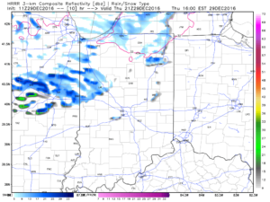
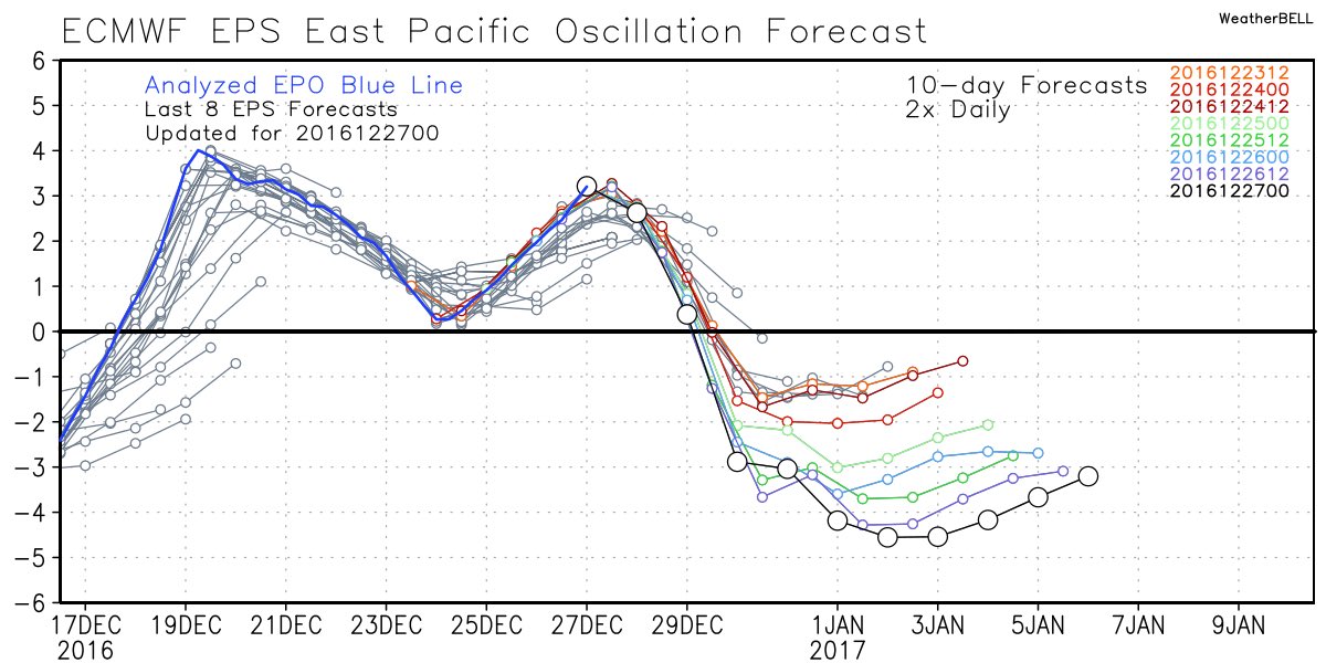
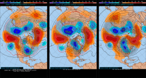
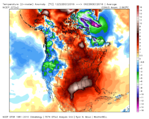
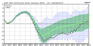
Accordingly, we see the ensemble data flipping to a colder pattern over the upcoming (10) days.  Note the low anomalies in the higher latitude regions today (Image 1) versus Day 10 (Image 2).

day1

day10
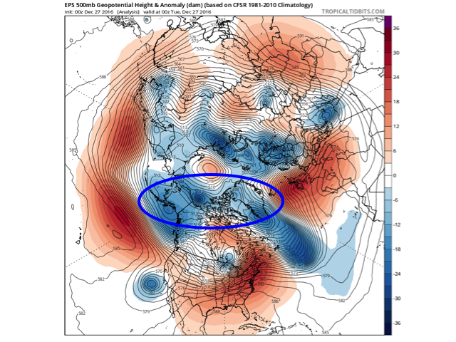
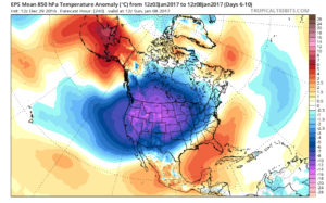
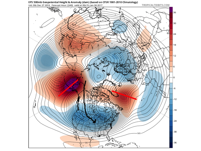
The pattern developing by Day (10) is one capable of producing another frigid regime- only January style.  Cross-polar flow sets up shop and, unlike, December, some blocking is noted, as well.  This can help the mean storm track shift further south.  (Bye-bye Great Lakes cutters, though Mid Western and Ohio Valley Snow Lovers will find a new worry in the form of suppression potential ;-)).  Individual storms will have their respected challenges, as always.  As a whole, it’s a very cold, stormy look and a pattern capable of leading to an expanding snow pack across the Lower 48.

Notes:  The new European Weeklies are in and reflect the general idea here of a more sustained cold, wintry pattern unfolding as January arrives.  The Weeklies are very cold through Weeks 2-3, in particular.  As far as snow goes, they also suggest an active storm track with numerous storms leading to an increasingly snowy regime through the middle parts of January, as well.  That said, we’re a bit hesitant to focus too much on the long-term snowfall details as the Weeklies have been too generous in the snow department over the past several weeks.  As a whole, it’s very tough to argue the pattern isn’t one that should yield the snowy “goods” in the coming weeks though.

More later!

Permanent link to this article: https://indywx.com/2016/12/27/new-year-new-pattern-awaits/

Unseasonably Warm; Wet Day After Christmas…

screen-shot-2016-12-26-at-8-33-12-amHighlights:

  • Unseasonably warm today
  • Showers and perhaps a t-storm by lunchtime
  • Turning more seasonable later this week

Wet At Times Today…A cold front will push across the state later this afternoon.  Ahead of the front, a warm southwesterly air flow will lead to a spring-like feel on this day after Christmas.  Coverage of showers will increase by late morning and around lunchtime, including the possibility of an embedded thunderstorm.  Once the front sweeps through the region, our winds will flip to the northwest and result in a cooler feel as early as tonight.  Tuesday will feature much more seasonable conditions.

Reinforcing chilly air will blow into town Thursday afternoon and with enough upper level energy around, we’ll mention scattered snow showers in our forecast.  Colder weather will be with us to close the week and head into New Year’s weekend.

Speaking of New Year’s, we still eye a storm system around New Year’s Eve.  Confidence is low in the overall set-up in regards to storm track and timing and fine tuning will be required.  For now, we’ll simply go with a developing light wintry mix Saturday and “sure up” the details later this week.

Upcoming 7-Day Precipitation Forecast:

  • Snowfall: Dusting
  • Rainfall: 0.50″ – 0.75″

Permanent link to this article: https://indywx.com/2016/12/26/unseasonably-warm-wet-day-after-christmas/

Merry Christmas Eve…

screen-shot-2016-12-24-at-8-03-42-amHighlights:

  • Areas of fog
  • Rising temperatures Christmas night
  • Turning more seasonable next week

Ah, Christmas Eve…From our home to yours, we wish you a very merry Christmas and a blessed holiday season.  It’s hard to believe Christmas Eve is upon us.  Despite areas of fog and an overcast, chilly day, weather really won’t present much of a challenge, locally, for travelers or last-minute shoppers (surely we don’t have any of those in central IN).  😉  Rudolph will be needed tonight as areas of fog and low clouds remain across portions of the state.

Conditions will remain damp and chilly into Christmas as most of the day remains in the 30s.  Our air flow will shift to the south Christmas afternoon and provide a late day boost on the thermometer into the 40s after dark and near 50 by midnight.  As we see the southerly wind erode the chilly conditions in place we’ll also have to be on the look out for a passing shower Christmas afternoon.

Better shower coverage will push in ahead of the cold front Monday morning.  An embedded clap of thunder is also possible.  Winds will shift to the NW with the passage of the cold front Monday afternoon and cooler air will spill into central IN Monday night. That high you see in the upper 50s will come just prior to the frontal passage.

After the mild start Monday, seasonable temperatures will return next week.  Models are struggling with handling a piece of energy the middle of next week.  We’ll keep an eye on it over the next day or so.  Scattered snow showers will likely accompany a push of colder air Thursday.

Upcoming 7-Day Precipitation Forecast:

  • Snowfall: Dusting
  • Rainfall: 0.50″-0.75″

Permanent link to this article: https://indywx.com/2016/12/24/merry-christmas-eve/

12.23.16 Ensemble Discussion On The 6-10 Day…

*A fresh 7-day will be updated late tonight or early Christmas Eve.*

Modeling continues to suggest a colder return looms as we close out 2016 and open 2017.  We’ve discussed the implications of a negative EPO and it certainly appears as if, at least initially, the negative EPO will do the “dirty work” to drive a colder regime in the 6-10 day period.

gefs_epo_12

epoold_neg_12dec
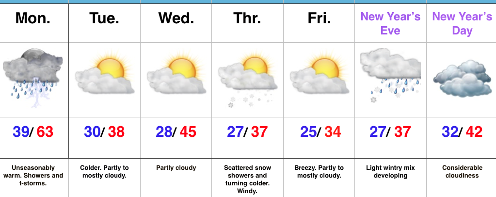
We note ensemble data is suggesting high latitude blocking tries to develop towards Day 10.  Recall this was the missing ingredient in the bitterly cold blasts of air that occurred during the first few weeks of December.  Both the GEFS and EPS agree on the increasingly blocky look to the pattern by Day 10.  This would help drive a cold, stormy pattern by early January.  Instead of storms cutting, we would see more suppression.  With a “stubborn” southeast ridge, things could get interesting across the Ohio Valley from a wintry perspective….

gefs12z122316

eps12z122316
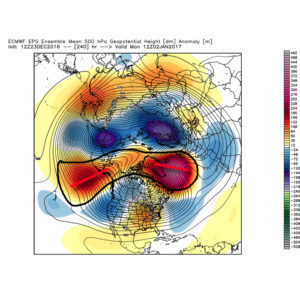
We don’t want to jump the gun, but it the positives can “hook up” over the pole, we stand the chance of locking into a rather lengthy cold, snowy regime as we rumble deeper into the heart of winter.

Given the look, it’s no surprise we see the 12z teleconnections want to continue the trend of a negative look to the NAO and AO in the medium to longer term.

12zeuronao122316

12zeuroao122316
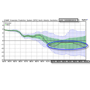
Summary:  A rather mild regime remains as we rumble through Christmas before trending more seasonable next week.  From a wintry perspective we need to continue to keep an eye on the period around New Year’s Eve/ Day.  Confidence continues to increase on the potential of a return of arctic air come early January.

Permanent link to this article: https://indywx.com/2016/12/23/12-23-16-ensemble-discussion-on-the-6-10-day/

Changeable Weather Christmas To New Years…

It’s hard to believe we’re only a few days from Christmas!  Through the 22nd, Indianapolis is running a whopping 6 degrees below average.  Cold rules across the Lower 48, month-to-date.

ncep_cfsr_noram_t2m_anom
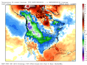
This is, of course, is in stark contrast to December 2015.

conus_mtd_t2max_anom_2015
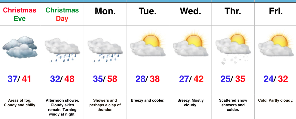
As we move forward, an active pattern awaits between now and the end of the year.  This comes after a few days to catch our breath, including moderating temperatures leading up to Christmas.

An initial wave of moisture will lift northeast and result in a rather gloomy day Friday with increasing rain chances Friday afternoon and evening.  Initially, precipitation won’t make it to the ground, but we should saturate the column enough that rain reaches the ground for most of central IN by evening.  Showers continue Friday night into the wee morning hours Christmas Eve.  (If traveling towards Chicago, a wintry mix and snow will be a good bet Friday PM).

hires_ref_ky_18Christmas Eve will feature overcast skies with areas of fog and drizzle, but the majority of the concentrated rain should fall south of the region.  Santa’s ride into central IN should be uneventful, weather-wise.

Christmas Day will start off with temperatures in the mid to upper 30s along with cloudy conditions and an increasingly gusty breeze that will shift out of the southeast to the south Christmas night.  Shower chances will be present by the evening before giving way to more widespread showers and embedded thunder overnight into Monday morning.  Temperatures will be stuck in the 40s most of the daytime Christmas before rising into the upper 50s predawn Monday.

gfs_ptype_slp_indy_17
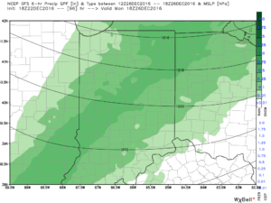
Temperatures will fall through the day Monday and we should run much closer to seasonable temperatures next week.  A couple of additional storm systems will have to be monitored for rain and snow prospects the middle of next week and again around New Year’s Eve/ Day.  Initially, we’ll be rather mild, but there may be more in the way of cold air readily available to make the storm system around New Years “more interesting” from a wintry perspective.

Longer term, we have to wonder if the negative EPO isn’t about to take control just past the New Year.  More and more data is coming around to the idea that the arctic hounds may (yet again) be on the attack early January… Time will tell and we’ll continue to keep a close eye on things.

test8

wpoepo

Permanent link to this article: https://indywx.com/2016/12/22/changeable-weather-christmas-to-new-years/

VIDEO: Rambling Around On A Wednesday Evening…

You must be logged in to view this content. Click Here to become a member of IndyWX.com for full access.  Already a member of IndyWx.com All-Access?  Log-in here.

Permanent link to this article: https://indywx.com/2016/12/21/video-rambling-around-on-a-wednesday-evening/

IndyWx.com