
You must be logged in to view this content. Click Here to become a member of IndyWX.com for full access. Already a member of IndyWx.com All-Access? Log-in here.
2016 archive
Permanent link to this article: https://indywx.com/2016/01/19/lots-to-look-at/
Jan 19
Busy, Busy (And Snowy)…
 Highlights:
- Another frigid start
- Snow develops tonight
- Watching late week winter storm potential
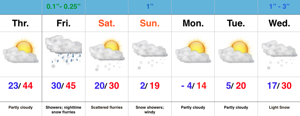
Snowy Commute Ahead Wednesday Morning…Back-to-back wintry events will impact at least portions of the region in the coming days. Before we talk snow, we’ll enjoy sunshine this morning before clouds begin to increase, thicken, and lower later today. Those clouds spell snow during the overnight and we still think snow will come down at a good clip for an hour, or two just before the morning rush (horrible timing, I know). A couple inches still looks like a good bet in, and around, Indy, with heavier totals off to the south.
We’ll go through a break in the action Wednesday afternoon, but all eyes at that point will already be focused to our SW. A developing winter storm will take shape in Texas Thursday and track northeast into the TN Valley Friday. Eventually the energy will transfer to a new area of low pressure east of the Appalachians that will create blizzard conditions across the mountains, Mid Atlantic, and portions of the Northeast late week. That said, enough of a reflection of the initial low should track up west of the mountains and help spread moisture far enough north to impact southern and southeastern parts of our region Thursday night into Friday. (A slight continued NW jog is still possible). It’s far too early to discuss amounts, but know that this could be an impactful event for some, particularly across southern and southeastern IN.
Dry and cold conditions will return for the weekend before we eye the potential of additional wintry “mischief” next week…

Permanent link to this article: https://indywx.com/2016/01/19/busy-busy-and-snowy/
Jan 18
Suppression Depression? Not So Fast, My Friend…
There’s been a tremendous amount of buzz concerning the late week winter storm, and for good reason. This will be a doozie for some (perhaps many) folks. While most data keeps this storm too far south and east for a big snow for Hoosiers, it’s wise not to write this storm off at this juncture.
A latest scan of the GFS ensembles show 9 of 21 members suggest snow impacts central IN Thursday night.
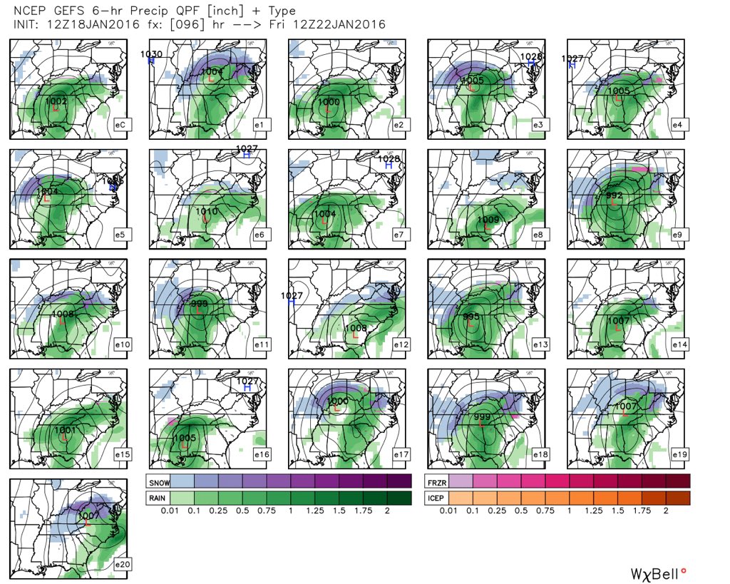
Source: Weatherbell.com
While we can’t show them here (due to licensing issues), we note 19 of 51 European ensemble members also agree on snow prospects for southern/ central IN.
Experience here (and during my time in the mountains of east TN) suggest time and time again that when surface lows track through the TN Valley, you’ll see a reflection of that low track west of the spine of the Appalachians before the new primary low forms east of the mountains. This takes place due to the natural impact of downsloping off the Appalachians. (We’ll bore you with the fascinating impacts of upsloping and downsloping at another time). 🙂 Is that far enough west to provide the “snowy goods” to central IN? Sometimes yes, and sometimes no. We’ll continue to keep a very close eye on things as we rumble closer towards late week and we suggest you do as well.
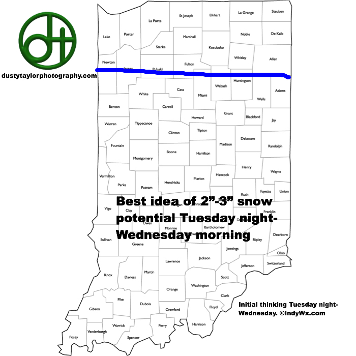
In the near term, challenges also abound. We still favor a swath of 2-3″ snows through the I-70 corridor tomorrow night-Wednesday morning. Upper level energy and the higher ratio snow should fluff those amounts up, despite current data tracking amounts south. We’ll keep a close eye on 00z data.
Much more later! Have a great evening!
Permanent link to this article: https://indywx.com/2016/01/18/suppression-depression-not-so-fast-my-friend/
Jan 18
Frigid Day; Watching Accumulating Snow Threat Tomorrow Night…
 Highlights:
- Frigid day
- Accumulating snow Tuesday night-Wednesday
- Late week winter storm threat south
- Active pattern continues next weekend
Bitterly Cold With Developing Snow Tuesday Night…It’s a bright, but frigid start to the day with mostly sunny skies in place. Temperatures are below zero for many this morning and ‘chills have dipped to as low as 20 below. If you have to be out today, layer up and limit time outdoors.
Clouds will quickly be on the increase Tuesday afternoon and snow will develop Tuesday night, continuing into Wednesday morning. Model data suggests snow may come down at a good clip at times early Wednesday morning. The initial snowfall map (below) places our best idea on accumulation for now. As we always say, this should be used as guidance at this distance and we’ll have to fine tune as we move forward.
The consensus of nearly all model data shifts our late week winter storm further south overnight. It’s too early to write this storm off, but we’ll trend our forecast drier in the Thursday-Friday time frame for now (that blocking high to our north can, at times, be a blessing and a curse ;-)). Another chance of snow rumbles in late in the weekend.
Permanent link to this article: https://indywx.com/2016/01/18/frigid-day-watching-accumulating-snow-threat-tomorrow-night/
Jan 17
Tracking Two Winter Events This Week…
It’s a busy time in the good ole (cozy) forecast office these days as we track (2) notable winter events this week.
Time Line:
- 1st event: Tuesday night-Wednesday
- 2nd event: Thursday night-Friday
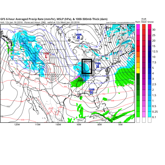
12z data is in and has been growing increasingly snowy for Tuesday night and Wednesday for a widespread portion of the area. At this distance, a “plowable” snow appears likely and we’ll fine tune specific numbers as time draws closer.
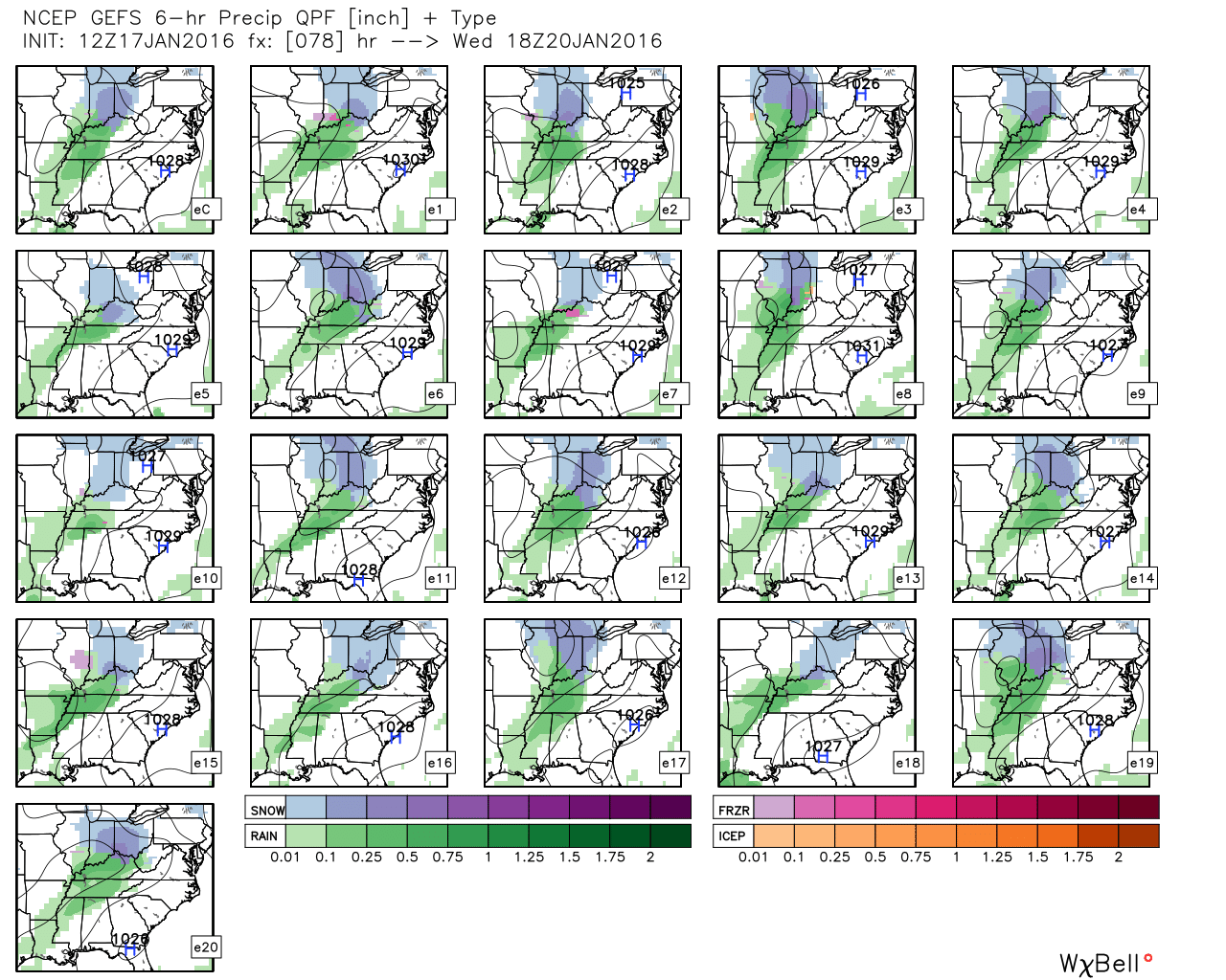
12z GFS ensemble members show very good agreement on the snow event ahead Tuesday night-Wednesday. Source: Weatherbell.com
Set-Up:
We expect upper level energy to dig southeast Tuesday morning and “slow” just enough to allow surface low pressure to develop Tuesday afternoon across southern MO. The surface wave will lift east-northeast into the lower Ohio Valley Wednesday and should spread a widespread swath of snow across central IN. In looking back at similar events in the past, we note that models usually continue to trend “snowier” with these type set-ups as time draws closer. This will likely be a rather impactful event, likely greatly hampering the Wednesday morning commute. Stay tuned.
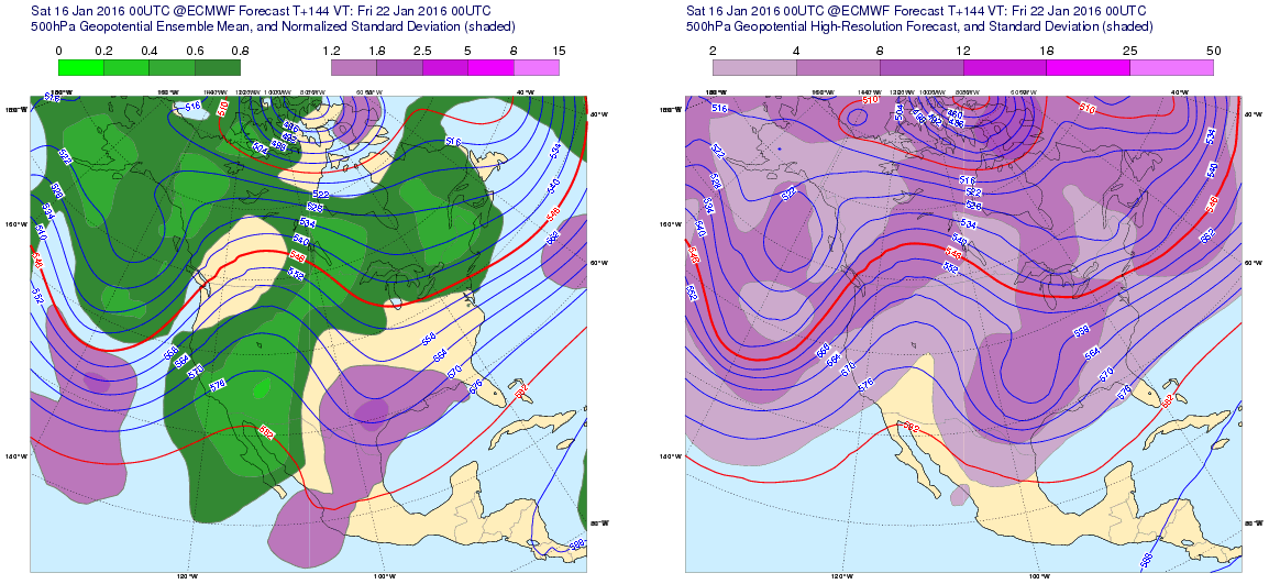
Just as we begin to clean up from Wednesday’s snow storm, eyes will shift to what may lie ahead in the Thursday night-Friday time period. The big question that remains with our second storm is the northward extent of the significant precipitation.
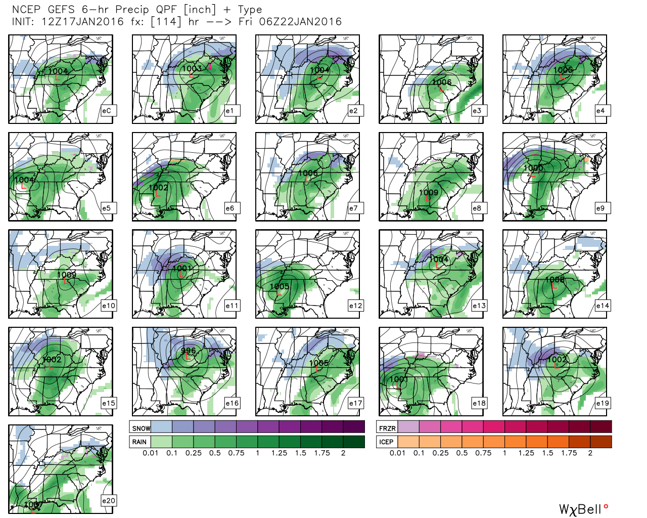
Individual ensemble members are much less in agreement when it comes to our late week winter storm threat. Source: Weatherbell.com

The European ensemble look at Day 5 has to make winter lovers smile from the southern Plains into the East. Source: Tropicaltidbits.com
Set-up:
Surface low pressure will develop across OK Wednesday evening and track ENE Thursday into Friday. The overall pattern supports a significant winter storm late week that will impact a widespread portion of the country. Looking at the big picture overview suggests we should see a winter storm spread significant snow (and ice for some) out of the central Plains, into the Ohio Valley and on into the Mid Atl and Northeast region. Of course we know no storm is alike, but leaning on past experience would suggest our second storm comes north a couple “clicks” in the days ahead. That said, there’s no doubt the northward extent will be limited by the blocking high (a key component to supplying the cold weather “goods”) to the north. Our advice at this point is to stay tuned closely to the Thursday night-Friday forecast and understand a significant winter storm is a good bet for at least portions of the region. We’ll have to fine tune the specifics as we move forward.
At the end of the day, hopefully most are realizing this winter, though late, has a lot of “winter” in it. We’re now dealing with our second surge of bitter arctic air in as many weeks and moving forward, the stormy pattern will continue to rumble through the upcoming 10-14 day period. This will continue to make-up for the slow start to the snow season.
Looking ahead, given the weakening Nino and a number of other factors, there’s plenty reason to see busy wintry times continue as we rumble through the 2nd half of winter.
Giddy up!
Permanent link to this article: https://indywx.com/2016/01/17/tracking-two-winter-events-this-week/
Jan 17
Active Wintry Week Ahead…
 Highlights:
- Frigid stretch of weather
- Accumulating snow mid week
- Winter storm potential late week
Busy Winter Pattern…Frigid air is helping usher in the new week and this morning’s snow bursts are setting the tone for potentially “more important” snow events in the days to come.
First things first though and that’s today. Morning snow showers and heavier squalls will diminish and give way to an absolutely bitter feel for the afternoon. Highs today took place at midnight and will continue to plummet through the day. We’ll be in the single digits by dinner. Wind chill values tonight and Monday will reach 20 degrees below zero. Ouch!
All eyes will then shift to an approaching mid week snow maker and this should be a “plowable” event for most. We expect a swath of snow to roll through central IN late Tuesday night into Wednesday morning.
Just as soon as the mid week snow maker moves out, we’ll have to turn our attention to late week. There are many questions regarding the northward extent of snow with this storm, but the overall set-up from this distance has to put a smile on the faces of Ohio Valley snow lovers. The blocking high to the north will be sufficient to supply cold air at the surface as moisture is supplied from the Gulf of Mexico, but it will limit how far north the low will track. Is this an Ohio Valley or TN Valley event? Ensemble data at the moment leads us to believe this will track far enough north to impact our region. We’ll have to sort through additional details in the coming days.
Permanent link to this article: https://indywx.com/2016/01/17/active-wintry-week-ahead/
Jan 16
Bitter Week Ahead; What About Snow Chances?
January to date is running 2 degrees above normal at IND. That number will drop significantly this week with the punch of arctic air inbound.
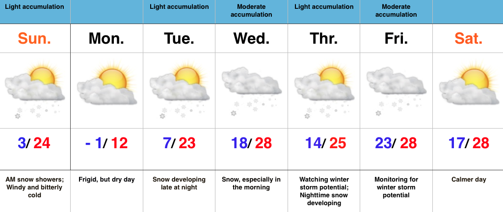
After a snowy week last week, we’ll attempt to make another run this week. Despite model inconsistencies, we focus on Sunday morning, Tuesday night-Wednesday morning, and late week for accumulating snow prospects. More on that in a minute.
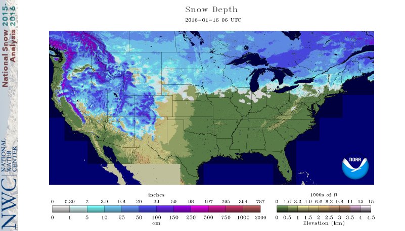
Note the difference in snow cover, locally, when compared to this time last year. Can we get things to look similar to image 2 below come late week? We’re on the playing field, at the very least.
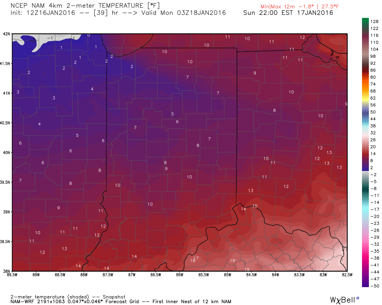
 The arctic surge of bitter air will blast into central IN Sunday morning late into the afternoon. Temperatures will be on the plunge, and reach the single digits come evening. Wind chill values will go below zero Sunday afternoon.

Forecast temperatures around lunchtime Sunday. Source: Weatherbell.com
Forecast temperatures Sunday evening. Source: Weatherbell.com.
A blast of snow showers and embedded squalls will accompany the arctic surge Sunday morning and may accumulate up to an inch in spots. Strong and gusty winds will create brief whiteout conditions from time to time.
 We eye the Tuesday night and Wednesday time frame for the next opportunity of accumulating snow. A “plowable” snow may be in the works during this time frame and we’ll continue to keep a close eye on things.
Wednesday morning as depicted by the 12z GFS. Source: Tropicaltidbits.com
Things remain very active moving forward. While the model specifics differ significantly at this juncture (no surprise ;-)), it’s important to look at the overall picture and see the potential of a fairly widespread winter event late next week.
Stay tuned. There are significant differences between the potential of this event and the reality of the past several more significant precipitation makers. – Namely a blocking cold high to the north as the more significant moisture arrives. This will help supply the cold and limit the northward track to a point. Is it a mostly snow event or do we get into the wintry mix potential? Many questions will have to be answered in the days ahead.
Permanent link to this article: https://indywx.com/2016/01/16/bitter-week-ahead-what-about-snow-chances/
Jan 15
Cold Weather Gear Required Moving Forward…
 Highlights:
- Rain develops today
- Frigid air awaits
- Tracking snow makers
Turning Wet Today; Big Cold Coming…It’s a mild start to our Friday, but overcast skies will give way to developing showers late morning, continuing through the afternoon hours. Colder air will push in tonight and may lead to a transition to wet snow before precipitation ends. Forecast models are struggling on handling the arrival of cold air and this will once again be a “now-cast” type situation as we go into the evening hours. When compared to last Saturday night’s event, this isn’t nearly as significant from a total precipitation standpoint, including snow totals.
Saturday will be a day where we’re in between storm systems. Morning flurries will be possible, but we continue to eye an arctic wave pushing into the area Sunday. Moisture will be limited, but with very cold air moving in, it won’t take much to “fluff up” a quick inch. The bigger deal will be strong and gusty winds and bitterly cold air.
Forecast models have really been struggling as of late and our overall confidence on how they handle things the middle of next week is quite low at the moment. That said, Wednesday-Thursday will require our attention moving forward for the prospects of accumulating snow. Another storm awaits late next week…
Permanent link to this article: https://indywx.com/2016/01/15/cold-weather-gear-required-moving-forward/
Jan 14
Arctic Invasion Awaits…
You must be logged in to view this content. Click Here to become a member of IndyWX.com for full access. Already a member of IndyWx.com All-Access? Log-in here.
Permanent link to this article: https://indywx.com/2016/01/14/arctic-invasion-awaits/
Jan 14
Thaw Will Be Brief; Arctic Hammer Set To Drop…
 Highlights:
- Brief thaw
- Coldest air of the season awaits
- Snow squalls accompany the arctic air
Enjoy Today; New Polar Plunge Coming…While we wait on the next severe blast of cold air, enough SW air flow will help boost temperatures to above normal levels today and Friday. We’ll introduce a few showers into the Friday forecast, so today is the “pick of the week!” Find a way to enjoy it!
What at one time looked like a significant storm system Friday into Saturday is now anything but. A very weak area of low pressure will provide showers Friday before transitioning to snow flurries as precipitation ends. Precipitation amounts will be light with this system.
Colder air begins to return tomorrow night and Saturday, but it’s Saturday night and Sunday that the next arctic invasion will get underway. By now you know the deal- we’ll also contend with snow showers and embedded heavier squalls, along with very gusty winds.
A frigid opening to next week will take place before we eye our next snow maker the middle of next week.
Permanent link to this article: https://indywx.com/2016/01/14/thaw-will-be-brief-arctic-hammer-set-to-drop/