 Highlights:
- Fast-moving storm system scoots north
- Wintry mix Friday night?
- Christmas night t-storm?
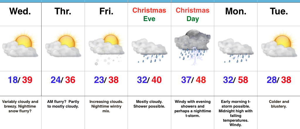
Chilly, But “Less Harsh”…The average high and low in central Indiana to wrap up December fall in the upper 30s and lower 20s, respectfully. While much milder than we’ve been, temperatures will be very close to seasonal norms as we rumble into Christmas weekend. A fast-moving storm system will scoot across the Great Lakes region Wednesday afternoon. Reinforcing chilly air (not of arctic origin) will blow in Wednesday night and Thursday. While a flurry could fly Wednesday night into Thursday morning, this won’t be a big deal.
We’ll then shift our focus to Christmas. An initial wave of moisture could result in a light wintry mix as early as Friday night. Initial thinking is that this won’t be a big deal as a quick transition to rain should take place early morning Christmas Eve, but, nonetheless, we’ll keep a close eye on things. A light shower may still be around Christmas Eve, especially during the first part of the day. Christmas Day, itself, should feature mostly dry, windy, and mild conditions. Wind-blown showers are possible by afternoon before intensity increases Christmas night, including the potential of a strong thunderstorm. The cold front will sweep through the state Monday morning with colder and windy conditions continuing Monday into Tuesday.
Longer-term, we remain confident that the “relaxed” state in the bitterly cold pattern will continue. However, please know that doesn’t mean we won’t have to deal with wintry threats over the next couple of weeks. An active storm track will continue through the Ohio Valley…
Upcoming 7-Day Precipitation Forecast:
- Snowfall: Dusting – 1″
- Rainfall: 0.50″ – 1.00″
