
You must be logged in to view this content. Click Here to become a member of IndyWX.com for full access. Already a member of IndyWx.com All-Access? Log-in here.
October 2016 archive
Permanent link to this article: https://indywx.com/video-briefly-cooler-thursday-before-a-windy-warm-up/
Oct 25
Tuesday Morning Briefing…
I’m on the road this morning so this will be quick (hoping to get a full 7-day out late tonight).
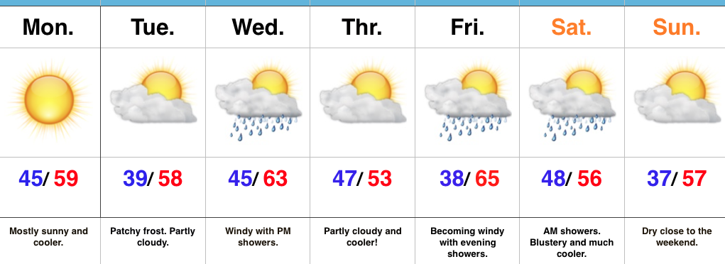
High pressure will supply a beautiful fall Tuesday. Patchy frost has been reported across central IN this morning (mid to upper 30s for some). Highs today will top out in the upper 50s to lower 60s with partly cloudy skies.
Our next storm system will serve to offer up showers by Wednesday evening (most around, or just after, the evening rush). It’ll be a windy day as well as SW winds gust over 30 MPH at times, especially during the afternoon.


A rumble or two of thunder is possible across central IN Wednesday evening and rainfall amounts should fall in the 0.25″-0.50″ range for most neighborhoods.
While we’ll turn briefly cooler behind the front to close the work week, the big news in an unseasonably warm close to October and open to November (several days with highs in the 70s develop this weekend into next week).

That said, MAJOR changes loom as mid November approaches. In fact, a rather dramatic shift towards a significantly colder and increasingly wintry feel looks likely as mid November approaches. This fits the pattern and analogs since summer.


Much more later tonight! Make it a great Tuesday!
Permanent link to this article: https://indywx.com/tuesday-morning-briefing/
Oct 23
Another Active Week…
 Highlights:
- Cool open to the work week
- Mid and late week fast-moving storm systems
- Weekend timing questions
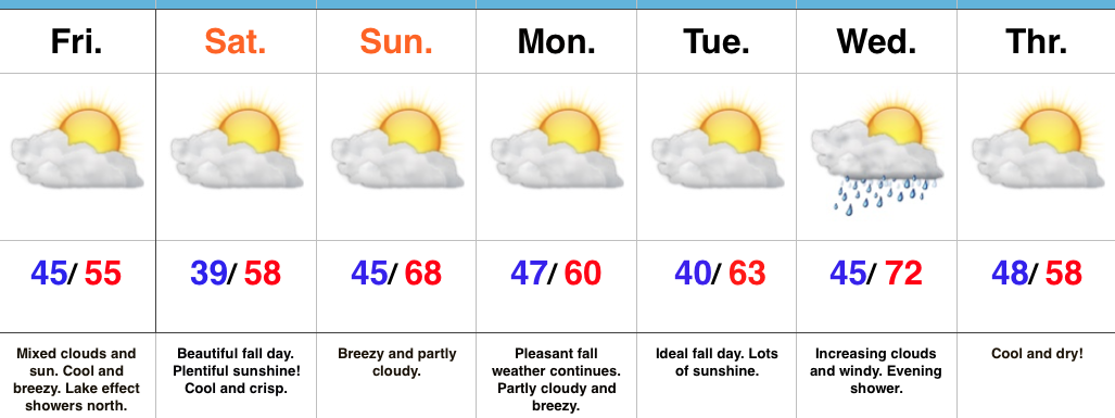
Fall Feel To Open The Week…A dry frontal boundary will pass through central IN late tonight. Our winds will shift to the NW after midnight and help drive in a cooler air mass to open up the new work week. Despite lots of sunshine, temperatures will be running below average to open the work week.
A fast-moving storm system will scoot through the lower Great Lakes region Wednesday. This will help serve to strengthen our winds (SW direction) along with create a chance of scattered showers Wednesday evening. Another pop of unseasonably cool air will blow into town Thursday.
Yet another storm system will press through the region as we get set to head into the weekend. Rainfall totals don’t look particularly impressive, but we’ll lean more towards the Friday night/ Saturday morning storm system as being the better rain-maker of the (2) systems this week. Cooler air will flow in behind the storm system for the weekend.
Upcoming 7-Day Precipitation Forecast:
- Snowfall: 0.00″
- Rainfall: 0.50″ – 0.75″
Permanent link to this article: https://indywx.com/another-active-week/
Oct 21
VIDEO: Weekend Weather Talk And Looking Into Next Week…
You must be logged in to view this content. Click Here to become a member of IndyWX.com for full access. Already a member of IndyWx.com All-Access? Log-in here.
Permanent link to this article: https://indywx.com/video-weekend-weather-talk-and-looking-into-next-week/
Oct 21
Increasing Sunshine; Unseasonably Cool Close To The Work Week…
 Highlights:
- Cool close to the work week
- Ideal autumn weekend
- Turning breezy early next week
- Scattered showers Wednesday PM
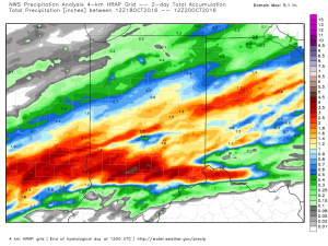
Grab The Jacket…After a significant rain event across central Indiana, the weekend will offer up a much-needed time to dry out! Here’s an illustration of where heaviest rains fell over the past 24-36 hours, courtesy of Weatherbell.com. Please note these aren’t official rainfall storm totals. Many ground-truth reports into the office include amounts of 1.5″-3″. Thanks to each of you for your reports!
 High pressure will build in over the weekend and create an increasingly sunny sky. The only caveat to that will be today where mixed clouds and sun across central IN become a little thicker and may yield lake effect rain showers across northern portions of the state later this afternoon.
We’ll turn briefly milder Sunday (upper 60s to around 70), but it’ll be a breezy day as a dry cold front sets it’s eyes on the region for a Sunday evening sweep! Reinforcing cool air will blow in to open the work week, but this should be a rain-free frontal passage as our air mass will be very dry.
The next storm system that could deliver rain arrives Wednesday evening. Along with scattered showers, a gusty SW wind can be expected before cooler air blows in to close next week.
Upcoming 7-Day Precipitation Forecast:
- Snowfall: 0.00″
- Rainfall: 0.10″ – 0.25″
Permanent link to this article: https://indywx.com/increasing-sunshine-unseasonably-cool-close-to-the-work-week/