Thursday Morning Video Update…
You must be logged in to view this content. Click Here to become a member of IndyWX.com for full access. Already a member of IndyWx.com All-Access? Log-in here.
You must be logged in to view this content. Click Here to become a member of IndyWX.com for full access. Already a member of IndyWx.com All-Access? Log-in here.
This content is password-protected. To view it, please enter the password below. Password:
You must be logged in to view this content. Click Here to become a member of IndyWX.com for full access. Already a member of IndyWx.com All-Access? Log-in here.
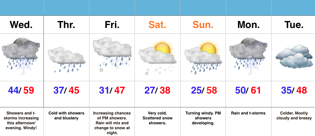 Highlights:
Active Times Continue…Despite some thunderstorms across northern portions of the state this morning, most are dry. That will change this afternoon and evening as widespread showers and embedded thunder increase in coverage. On average, expect 0.25″-0.50″ by tonight. Winds will also be gusty (40 MPH+).
We’ll shift into a much colder pattern to wrap up the work week and upper level energy will help produce showers Thursday. As even colder air gets involved, rain will transition to snow Friday night into Saturday morning. Saturday will be downright cold.
Another wet weather maker approaches early next week. After a hard freeze Sunday morning, things will cloud up, turn windy, and feature evening showers. More widespread rains and storms arrive on the scene Monday. Colder air returns Tuesday!
This content is password-protected. To view it, please enter the password below. Password:
You must be logged in to view this content. Click Here to become a member of IndyWX.com for full access. Already a member of IndyWx.com All-Access? Log-in here.
This content is password-protected. To view it, please enter the password below. Password:
You must be logged in to view this content. Click Here to become a member of IndyWX.com for full access. Already a member of IndyWx.com All-Access? Log-in here.