April 26, 2016 archive
This content is password protected. To view it please enter your password below: Password:
You must be logged in to view this content. Click Here to become a member of IndyWX.com for full access. Already a member of IndyWx.com All-Access? Log-in here.
Permanent link to this article: https://indywx.com/2016/04/26/long-range-client-video-discussion-3/
 Highlights:
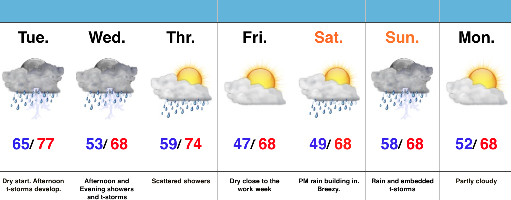
- T-storms develop this afternoon
- Another round of showers and t-storms push in Wednesday afternoon/ evening
- Briefly drier Friday
- New storm delivers a wet weekend
Turning Noisy This Afternoon…It’s a relatively quiet start to the day across central IN, but a cold front will help ignite rather robust shower and thunderstorm development as early as the lunchtime hour. Storms will grow in intensity and coverage as we progress through the afternoon and evening, especially along I-70 and points south. Locally heavy rain will be likely. Stronger storms will be capable of producing hail and damaging winds.
Another round of showers and thunderstorms are on deck Wednesday afternoon and evening. When all is said and done by Thursday morning, widespread rain totals of 1″ to 1.5″ will be a good bet, with locally heavier amounts.
Friday will feature a beautiful close to the work week with drier air working in and some sunshine. That said, the sunny skies won’t last as showers and thunderstorms return over the weekend.
Permanent link to this article: https://indywx.com/2016/04/26/thunderstorms-fire-this-afternoon/

