April 24, 2016 archive
This content is password protected. To view it please enter your password below: Password:
You must be logged in to view this content. Click Here to become a member of IndyWX.com for full access. Already a member of IndyWx.com All-Access? Log-in here.
Permanent link to this article: https://indywx.com/2016/04/24/long-range-client-video-update-2/
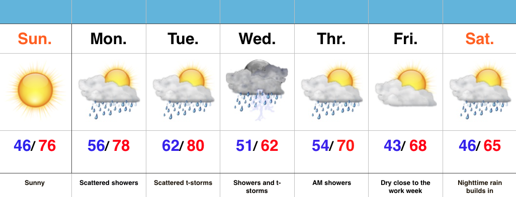
 Highlights:
- Sunny close to the weekend
- Warm and increasingly humid early week with showers
- Widespread rain and storms Wednesday
- Significant rain maker to open May
Good Supply Of Vitamin D…High pressure will remain in control of our weather today and supply mostly sunny skies and warm temperatures. Get outside and enjoy!
Moisture will begin to increase as we progress through the early portions of the work week with showers and scattered thunderstorms developing Monday into Tuesday. We’ll still enjoy lots of dry time in between the scattered showers.
More widespread showers and thunderstorms will push into the state Wednesday. Early numbers suggest amounts of 0.75″-1″. Lingering showers remain Thursday morning, but we should get a nice push of dry air in here Thursday afternoon into Friday.
Attention will then shift to a significant system that promises to provide heavy rain and embedded thunderstorms as early as Saturday night. We still have time to watch this, but from this distance it appears as if this will be a “juicy” storm system. We’re also eyeing a much cooler open to May…
Permanent link to this article: https://indywx.com/2016/04/24/beauty-of-a-sunday/

