December 2014 archive
1.) Light snow will try and spread towards central Indiana Thursday, but this will really run into dry air and struggle to make it into the area. Radars to our…
You must be logged in to view this content. Click Here to become a member of IndyWX.com for full access. Already a member of IndyWx.com All-Access? Log-in here.
Permanent link to this article: https://indywx.com/2014/12/17/wednesday-morning-rambles-4/
|
Tue.
|
Wed.
|
Thr.
|
Fri.
|
Sat.
|
Sun.
|
Mon.
|
|

|

|

|

|

|

|

|
|
34/ 46
|
28/ 34
|
23/ 32
|
27/ 35
|
29/ 33
|
29/ 36
|
27/ 37
|
Highlights:
- Tuesday Showers
- Weekend Snow For Some
- Pre-Christmas Wintry Event
Showers; Turning Colder Late…Showers will remain in our forecast today. Most widespread rain will occur during the early morning hours, but we’ll maintain mention of light showers in our forecast even into the afternoon. Winds will be gusty and help drive colder air into central Indiana later this evening. We forecast nearly steady temperatures during the morning and afternoon hours before falling temperatures during the evening.
Dry, But Cold Mid Week…We’ll welcome a drier regime for the midweek period, along with partly to mostly cloudy skies and colder conditions.
Eyeing The Weekend…There’s not much change in our overall thinking of a potentially snowy first half of the weekend for some. Monday featured run-to-run inconsistencies on our weekend storm system and we fully expect additional changes within the model data during the next couple of days. In building our forecasts we factor in current data, but also rely on past data of storm tracks with similar setups.
At the end of the day (and despite model inconsistencies) we still think one area of low pressure heads northeast out of the mid MS River Valley into the Ohio Valley Friday night into Saturday. A secondary area of low pressure is then expected to organize along the mid Atlantic coast Saturday afternoon. Widespread light snow should build into the Ohio Valley Saturday with the above set up. Exactly where heavier snow sets up is still up for much debate and will require fine tuning as we move forward.
Christmas Travelers Keep Close Tabs On The Forecast…After our first opportunity of potential wintry weather we’ll enjoy only a day or two of calmer weather in between storms. Longer range data suggests we need to keep abreast of another winter event just prior to Christmas.
Upcoming 7-Day Precipitation Forecast:
- 7-Day Rainfall Forecast: 0.25″ – 0.50″
- 7-Day Snowfall Forecast: 1″ – 2″
Permanent link to this article: https://indywx.com/2014/12/15/3276/
Additional showers will rotate through central Indiana during the overnight, followed by a colder mid week stretch. All eyes remain on the weekend for an impactful winter weather event across…
You must be logged in to view this content. Click Here to become a member of IndyWX.com for full access. Already a member of IndyWx.com All-Access? Log-in here.
Permanent link to this article: https://indywx.com/2014/12/15/monday-evening-video-brief/
1.) Rain will spread into the state later this afternoon. Most folks will see 0.25″-0.50″. 2.) Colder air will filter into the region by the mid week period and help…
You must be logged in to view this content. Click Here to become a member of IndyWX.com for full access. Already a member of IndyWx.com All-Access? Log-in here.
Permanent link to this article: https://indywx.com/2014/12/15/monday-morning-rambles/
|
Mon.
|
Tue.
|
Wed.
|
Thr.
|
Fri.
|
Sat.
|
Sun.
|
|

|

|

|

|

|

|

|
|
40/ 50
|
33/ 45
|
25/ 35
|
25/ 35
|
25/ 34
|
28/ 32
|
26/ 33
|
Highlights:
- Early Week Rain Maker
- Keeping An Eye On Mid Week
- Weekend Winter Storm For Some
Early Week Storm System…An area of low pressure will scoot though the Ohio Valley Monday into Tuesday delivering showers to the region. We forecast rain to arrive late morning to early afternoon Monday across central Indiana. We’re not expecting heavy rain, but plan on taking the rain gear with you as you leave for work and/ or school. Colder air will filter into the state Tuesday afternoon setting up a cold mid week period.
Some forecast models have hinted at the threat of light wintry precipitation Wednesday into Thursday, but for now we’re keeping this out of our official forecast and instead going with a mostly cloudy, but dry mid week period.
Developing Weekend Winter Storm…All eyes will focus on a significant weekend winter storm event. Details on track are still up for debate with this being in the mid range period and we’ll keep close tabs as we move forward through the week. As of now we forecast increasing clouds through the day Friday with light snow developing late Friday night and continuing into Saturday. Snowfall totals will obviously depend on the track of the low and we’re still a few days away from being able to provide any sort of specific accumulation ideas. Guidance right now ranges from a “plowable” event to one that misses us to the south and east. Stay tuned.
The weather pattern continues to look cold and active in the days leading up to, and through, the Christmas and New Year’s period. Buckle up for a fun ride…
Upcoming 7-Day Precipitation Forecast:
- 7-Day Rainfall Forecast: 0.25″ – 0.50″
- 7-Day Snowfall Forecast: 1″ – 2″
Permanent link to this article: https://indywx.com/2014/12/14/busy-week-ahead/
Colts v. Texans Forecast Prepared For:
The Indiana Sports Report
12.14.14
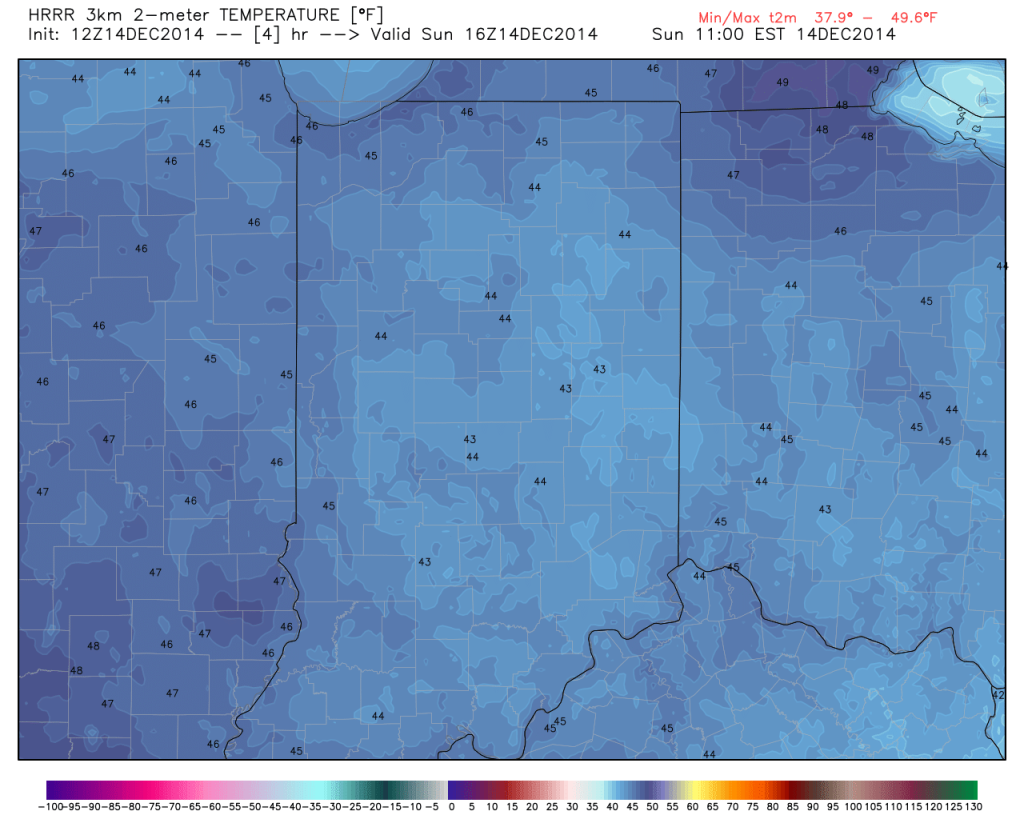
Happy game day Colts fans! – New day; same story…central Indiana will remain under the influence of an “inversion” and this will keep low clouds and areas of fog prevalent for most of the day. Milder air in the 50s at 4,000-5,000 feet up is overrunning shallow cooler air that’s trapped at the surface and the result in more of the same- gloomy, cloudy, foggy weather. While temperatures won’t be as mild as they could be without the inversion, tailgaters still can’t complain about 45-50 degree air this time of year :-). Visit IndyWx.com for “Indy’s Behind The Scenes Weather” all season long! Go Colts!
|
Tailgate Weather
|
Kickoff Weather
|
Heading Home
|
| Cloudy and foggy; patchy drizzle |
Cloudy with areas of fog; patchy drizzle |
Cloudy with areas of fog; patchy drizzle |
| Temp: 41-45 |
Temp: 46 |
Temp: 50 |
| Wind: S 5-10 MPH |
Wind: S 5-10 MPH |
Wind: S 5-10 MPH |
| Precip: Trace |
Precip: Trace |
Precip: Trace |

Despite low clouds and areas of drizzle, temperatures will be mild this morning for tailgaters!

Permanent link to this article: https://indywx.com/2014/12/14/mild-foggy-with-areas-of-drizzle-for-colts-vs-texans/
|
Sat.
|
Sun.
|
Mon.
|
Tue.
|
Wed.
|
Thr.
|
Fri.
|
|

|

|

|

|

|

|

|
|
31/ 44
|
38/ 50
|
40/ 50
|
35/ 48
|
27/ 35
|
26/ 35
|
25/ 35
|
Highlights:
- Weekend Inversion
- Early Week Storm System
- Keeping Close Eyes On Next Weekend
Gloomy Weekend…Forecast models continue to suggest we deal with an inversion though the weekend and this will keep low clouds hanging tough along with areas of fog (be careful tonight into Saturday morning for areas of freezing fog). The warmer air is moving in aloft, but at the surface cold air remains hard to budge this weekend. Just think…if we could shake the low clouds and fog, temperatures would have no problem climbing well into the middle and upper 50s. Instead we forecast lower and middle 40s Saturday and upper 40s and lower 50s Sunday. Again, low clouds and areas of fog will hang tough, along with patchy drizzle.
Early Week Storm System…An area of low pressure will “bowl” across the middle of the country and result in developing showers late Monday, continuing into Tuesday. Temperatures will be too mild to support anything other than rain with our Monday-Tuesday system.
Colder; Eyeing Next Weekend…We’ll see a return of below normal cold for the second half of next week. Forecast models differ on Thursday’s solution and vary from a cold, dry day to one that features mixed rain and snow. For now, we’ll side with the dry theme for now, but suggest staying tune. A more “interesting” system awaits next weekend…
Upcoming 7-Day Precipitation Forecast:
- 7-Day Rainfall Forecast: 0.25″ – 0.50″
- 7-Day Snowfall Forecast: 0.00″
Permanent link to this article: https://indywx.com/2014/12/12/weekend-inversion/
-
Filed under AO, Arctic Cold, Christmas/ Thanksgiving, Forecast Discussion, Forecast Models, GFS, Long Range Discussion, snow, Unseasonably Cool Weather, Winter thoughts...
-
December 11, 2014
Modeling continues to suggest a cold and wintry time lies ahead as we progress into and through the special Christmas period. Could this be the scene across central Indiana Christmas…
You must be logged in to view this content. Click Here to become a member of IndyWX.com for full access. Already a member of IndyWx.com All-Access? Log-in here.
Permanent link to this article: https://indywx.com/2014/12/11/im-dreaming-of-a-white-christmas/
|
Wed.
|
Thr.
|
Fri.
|
Sat.
|
Sun.
|
Mon.
|
Tue.
|
|

|

|

|

|

|

|

|
|
29/ 36
|
28/ 38
|
28/ 43
|
32/ 45
|
39/ 48
|
42/ 51
|
33/ 44
|
Dirty High…High pressure is in control of our weather, but this is what we call a “dirty high” as low clouds will remain today along with a couple light flurries, particularly across western parts of the state. Temperatures will remain colder than average.
Sunshine will finally begin to increase as we go into the latter portion of the work week along with slowly moderating temperatures closer to seasonal levels.
Tricky Weekend…The upper air pattern this weekend will feature a building ridge across the Mid West and Ohio Valley and signal milder days ahead. Taken at face value one would anticipate temperatures well into the 50s and flirting with 60, but there will likely be an “inversion” that develops over the weekend which will lead to lots of clouds, drizzle, and cooler temperatures that what we’d expect without this inversion. As such, we’re forecasting increasing clouds Saturday and considerable cloudiness with areas of drizzle Sunday. Temperatures, though milder than normal, won’t reach levels they could in this type pattern without the inversion.
Early Week Storm System…Our next storm system will arrive late Monday into Tuesday with light rain and colder air returning for the middle of next week.
Upcoming 7-Day Precipitation Forecast:
- 7-Day Rainfall Forecast: 0.25″ – 0.50″
- 7-Day Snowfall Forecast: 0.00″
Permanent link to this article: https://indywx.com/2014/12/10/dirty-high-in-control/
-
Filed under 7-Day Outlook, Arctic Cold, Canadian Model, Forecast Discussion, Forecast Models, GFS, HRRR, Long Range Discussion, PNA, Rain, snow, Unseasonably Cool Weather, Unseasonably Warm, Winter thoughts...
-
December 9, 2014
December so far has been a battle between the cold northern tier and warmth south. The so-called “battle zone” has been located over our neck of the woods and lead…
You must be logged in to view this content. Click Here to become a member of IndyWX.com for full access. Already a member of IndyWx.com All-Access? Log-in here.
Permanent link to this article: https://indywx.com/2014/12/09/a-look-at-where-weve-been-and-where-were-going-4/


