August 2014 archive

Continued Steamy; Afternoon Storms In Spots…

Sat.

Sun.

Mon.

Tue.

Wed.

Thr.

Fri.

 Status-weather-showers-day-icon

 Status-weather-showers-day-icon

 Status-weather-clouds-icon

 Status-weather-clouds-icon

 Status-weather-showers-day-icon

 Status-weather-showers-day-icon

 Status-weather-showers-day-icon

70/ 89

70/ 88

71/ 90

70/ 90

 71/ 90

70/ 88

68/ 85 

Steamy…Plan for plenty of heat and humidity this weekend.  Sunshine can be expected both days, but evening and nighttime storms will be scattered about the region.  We don’t anticipate as widespread coverage as compared to late last week, but some locally heavy downpours will be around Saturday and Sunday, including the chance of more localized flooding.

Hot, Hot, Hot…The ridge will expand early next week and this will essentially eliminate rain chances Monday and Tuesday (only isolated coverage at best).  Additionally, this will allow temperatures to reach the lower 90s for many communities across central Indiana.

Late Week Cold Front…We forecast more unsettled weather to develop late next week as a cold front draws closer to the area and the ridge begins to break down.  Scattered to numerous showers and thunderstorms lie ahead once past mid week, with best rain chances in the forecast period above likely arriving Friday.

7-Day Precipitation Forecast:

  • 7-Day Rainfall Forecast: 0.50″-1.00″ (locally heavier totals)
  • 7-Day Snowfall Forecast: 0.00″
Highs may reach 90 in a couple spots today, but we forecast Indy's official Saturday high at 89.

Highs may reach 90 in a couple spots today, but we forecast Indy’s official Saturday high at 89.

Permanent link to this article: https://indywx.com/2014/08/23/continued-steamy-afternoon-storms-in-spots/

Cooler To Open September?

As we move through the next week, we continue to think we’ll cool things off as we wrap up August. We’re not talking about any sort of major unseasonably cool…

You must be logged in to view this content. Click Here to become a member of IndyWX.com for full access.  Already a member of IndyWx.com All-Access?  Log-in here.

Permanent link to this article: https://indywx.com/2014/08/22/cooler-to-open-september/

Periods Of Storms; Localized Flooding…

Fri.

Sat.

Sun.

Mon.

Tue.

Wed.

Thr.

 Status-weather-showers-day-icon

 Status-weather-showers-day-icon

 Status-weather-showers-day-icon

 Status-weather-showers-day-icon

 Status-weather-clouds-icon

 Status-weather-showers-day-icon

 Status-weather-showers-day-icon

74/ 88

72/ 89

72/ 90

72/ 90

71/ 91

70/ 88

69/ 83 

More Storms To Go…Our “ring of fire” pattern continues into the weekend and as disturbances ride the periphery of the heat dome to our south, periods of thunderstorms will be the result here.  Locally heavy rain will be possible with each storm complex and localized flooding will result.  Some extreme rainfall amounts of 5-8″ has been reported over the past couple days across north-central Indiana where training of storms has occurred.

After our current storm complex moves southeast, we think we deal with an additional couple of storm complexes late tonight into early Saturday and again Saturday evening.  Overall coverage of storms will be on the decline as we go deeper into the weekend, but rain can’t be totally eliminated from your forecast.

Hot And Humid…While we may fall a degree or two shy of the polarizing 90 degree mark, it’ll still feel mighty hot and humid today and Saturday. As rain and storm chances begin to decrease, that’ll allow us to take temperatures up a couple notches late weekend into early next week.  We forecast lower 90s Sunday through at least next Tuesday.

Late Month Relief…We still forecast a cooler pattern developing to wrap up August and move into September.  Much more on this in the coming days.  Right now, the big story remains the storm chances in the short term.

7-Day Precipitation Forecast:

  • 7-Day Rainfall Forecast: 2.00″ (locally heavier totals)
  • 7-Day Snowfall Forecast:  0.00″
Another complex of rain and strong storms will rumble in tonight/Saturday morning.

Another complex of rain and strong storms will rumble in tonight/Saturday morning.

Permanent link to this article: https://indywx.com/2014/08/22/periods-of-storms-localized-flooding/

More Storms To Go…

Another night, another round of storms! Our busy and stormy “ring of fire” pattern continues and will promote additional storm complexes Friday morning (followed by more stormy times Friday night/…

You must be logged in to view this content. Click Here to become a member of IndyWX.com for full access.  Already a member of IndyWx.com All-Access?  Log-in here.

Permanent link to this article: https://indywx.com/2014/08/21/more-storms-to-go/

Another Couple Rounds Of Storms…

Tonight’s video covers what’s likely to be another couple rounds of showers and thunderstorms that move through the region and provide embedded severe and locally heavy rain. PWAT values reach…

You must be logged in to view this content. Click Here to become a member of IndyWX.com for full access.  Already a member of IndyWx.com All-Access?  Log-in here.

Permanent link to this article: https://indywx.com/2014/08/21/another-couple-rounds-of-storms/

Storms And Heat…

Good morning and happy Thursday! This will be a quick post this morning before a more extensive update and 7-day outlook later this evening. The SPC highlights our region for…

You must be logged in to view this content. Click Here to become a member of IndyWX.com for full access.  Already a member of IndyWx.com All-Access?  Log-in here.

Permanent link to this article: https://indywx.com/2014/08/21/storms-and-heat/

Wednesday Morning Rambles…

The combination of passing storms and the setting sun Tuesday evening provided sun incredible rainbows. Thanks to John Feister for sharing this photo taken near Whitestown. John Salewicz snapped this…

You must be logged in to view this content. Click Here to become a member of IndyWX.com for full access.  Already a member of IndyWx.com All-Access?  Log-in here.

Permanent link to this article: https://indywx.com/2014/08/20/wednesday-morning-rambles-2/

Strong To Severe Storms, Big Heat, And Tropics!

Highlights of tonight’s video: Strong to severe storms Active pattern continues Serious weekend heat Tropics turn active PS: We continue to experience technical issues with a slight lag on audio/…

You must be logged in to view this content. Click Here to become a member of IndyWX.com for full access.  Already a member of IndyWx.com All-Access?  Log-in here.

Permanent link to this article: https://indywx.com/2014/08/19/strong-to-severe-storms-big-heat-and-tropics/

Still Focused On This Evening For Severe Storm Potential.

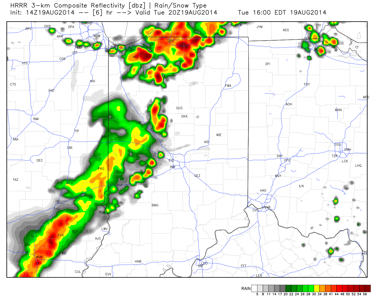
A look at some of the latest data hot off the press suggests we remain under fire for the potential of scattered strong to severe thunderstorms late afternoon into the evening hours.  Initial activity could fire as early as 3-4 o’clock across western sections.  The latest HRRR forecast radar (valid at 4pm) shows an advancing line of strong, and possibly severe, storms pushing east.

hrrr_ref_indy_7

Again, the primary threat is damaging wind, but a couple hail reports will also be possible.

As of the 12 o’clock hour, a complex of thunderstorms sits to our west across western/ central portions of Illinois.  We’ll keep a close eye on this complex as it continues pushing east and likely intensifies in a hot, humid, and unstable air mass over the next few hours.  Please plan a way to keep abreast of the latest radar and local media this afternoon and evening as storms move in.

Permanent link to this article: https://indywx.com/2014/08/19/still-focused-on-this-evening-for-severe-storm-potential/

Severe Weather Possible This Evening…

The day is dawning bright with lots of sunshine. Patchy fog is being reported in spots, but isn’t as widespread as Monday morning. The majority of today will be dry,…

You must be logged in to view this content. Click Here to become a member of IndyWX.com for full access.  Already a member of IndyWx.com All-Access?  Log-in here.

Permanent link to this article: https://indywx.com/2014/08/19/severe-weather-possible-this-evening/

IndyWx.com