March 2014 archive

Beauty Of A Close To The Work Week…

Fri.

Sat.

Sun.

Mon.

Tue.

Wed.

Thr.

 Status-weather-clouds-icon

 Status-weather-showers-scattered-icon

 Status-weather-clouds-icon

 Status-weather-clouds-icon

 Status-weather-clouds-icon

 Status-weather-snow-scattered-icon

 Status-weather-clouds-icon

21/ 53

30/ 46

21/ 45

33/ 60

40/ 61

21/ 40

13/ 32

– – –

Light

– – –

– – –

– – –

Light

– – –

Forecast Updated 03.07.14 @ 7:30a

Get Outside & Enjoy…We’re going to wrap up the work week with beautiful conditions.  If you can get out of work or school early today, IndyWx.com highly recommends it :-)!  High pressure will support sunny skies (after a little morning fog in spots) and milder temperatures.  Highs will zoom into the lower to middle 50s this afternoon!

Weak Weekend System…A weak cold front will slip south through the region Saturday.  Early morning sunshine will quickly give way to increasing clouds and developing light rain.  Rain will end as a period of light snow Saturday evening, but won’t accumulate.  The key word in all of this is light, with rainfall totals under a tenth of an inch.

Sunday will be a dry, chilly day with highs in the middle 40s.

True Spring Feel…The spring crave will be in full effect early next week as highs both Monday and Tuesday shoot into the lower 60s with sunshine.  We’ll notice a gusty westerly breeze Monday, assisting with the milder surge of air into the Ohio Valley.

Late Season Winter Storm Brewing?  Many questions remain around the ultimate track of the storm system by the middle of next week.  As of now, a blend of forecast model suggests a rain-to-snow scenario Wednesday, but it’s far too early to talk accumulations.  We’ll be able to fine tune some things over the weekend and have a better idea soon in regards to precipitation type and amount.  Regardless, a much colder air mass will pour into the region by the middle of next week.

Upcoming 7-Day Precipitation Forecast:

  • 7-Day Snowfall Forecast: 1-3″
  • 7-Day Rainfall Forecast: 0.10″ – 0.25″

twic

For weather updates and more “behind the scenes” data on the go, be sure to Follow Us on Twitter @indywx or become a Friend of IndyWx.com on Facebook!

images

Permanent link to this article: https://indywx.com/2014/03/07/beauty-of-a-close-to-the-work-week/

Thursday Evening Video Update…

Quick video update tonight to cover a couple of things: Southeast rain and western NC winter event. Beauty of a close to the work week here! More “rumblings” of a…

You must be logged in to view this content. Click Here to become a member of IndyWX.com for full access.  Already a member of IndyWx.com All-Access?  Log-in here.

Permanent link to this article: https://indywx.com/2014/03/06/thursday-evening-video-update/

Spring “Tease” On The Way…

Thr.

Fri.

Sat.

Sun.

Mon.

Tue.

Wed.

 Status-weather-clouds-icon

 Status-weather-clouds-icon

 Status-weather-showers-scattered-icon

 Status-weather-clouds-icon

 Status-weather-clouds-icon

 Status-weather-showers-day-icon

 Status-weather-snow-scattered-icon

18/ 40

25/ 55

30/ 44

21/ 45

33/ 60

42/ 54

29/ 38

– – –

– – –

Light

– – –

– – –

Light

Light

Forecast Updated 03.06.14 @ 7:45a

Moving In The Right Direction…We set the stage today with a storm that, thankfully, won’t impact our region- a big Gulf of Mexico low pressure system will blow ashore this evening and result in heavy rain and thunderstorms for the southeast.  Meanwhile, as the low lifts northeast, a big snow and ice event will occur across the western portions of North Carolina tonight.

Back here on the home front, we’ll enjoy increasing sunshine today after some morning cloudiness.  Though temperatures will remain below seasonal averages, we’re moving in the right direction, as highs should hit the 40 degree mark for many- a vast improvement from earlier this week.  This will then lead to a beautiful close to the work week- lots of sunshine and mild temperatures.

Brief Weekend Set Back…A cold front will drop south through the region Saturday morning and this will be accompanied by a light band of rain, eventually mixing with snow before ending.  This won’t be a big rain or snow maker by any stretch of the imagination as moisture will be limited.  Temperatures will slide backwards through the day and this will set the stage for a dry, though chilly Sunday.  We’ll note an increasing westerly breeze (a sign of warmer times ahead) Sunday afternoon and gusts could approach 30 MPH.

Spring Tease…The weekend will be bookended by spring-like weather and Monday will actually “out do” Friday as highs zoom close to the 60 degree mark with sunshine and gusty southwest winds.  Looking down the road, you better be sure to enjoy Monday!

Eyeing Mid Next Week…We have far more questions than answers right now concerning the potential storm by the middle of next week.  (You can read more here).  For now we’ll simply go with late day rain Tuesday transitioning to light snow Wednesday in a much colder air mass.  Stay tuned.

Upcoming 7-Day Precipitation Forecast

  • 7-Day Snowfall Forecast: 1″-2″
  • 7-Day Rainfall Forecast:  0.10″-0.25″

twic

For weather updates and more “behind the scenes” data on the go, be sure to Follow Us on Twitter @indywx or become a Friend of IndyWx.com on Facebook!

images

Permanent link to this article: https://indywx.com/2014/03/06/spring-tease-on-the-way/

“Trouble” Brewing Mid Month.

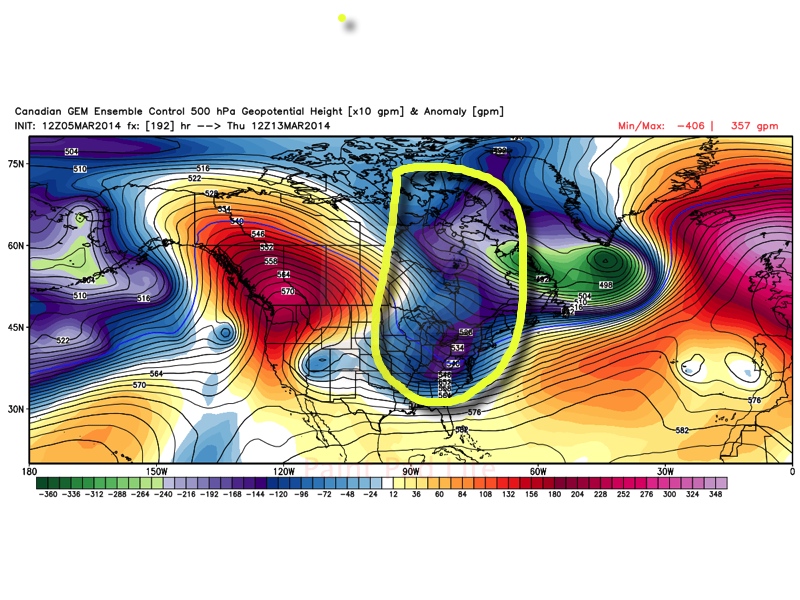
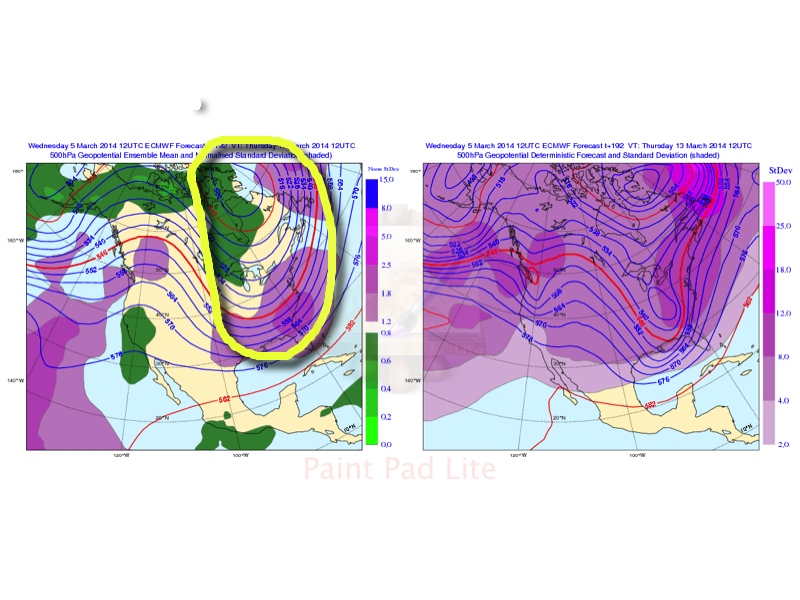
We continue to closely monitor the goings on towards the middle of the month- more specifically March 12th through the 14th.  There are indications a significant late season winter storm is brewing and the overall pattern is one that is aligning itself in a way that certainly has to raise an eye brow.  That said, it’s far too early for precise details.  Is a major storm possible?  Absolutely.  Is it okay to pin down a given area for heavy snow totals at this stage?  Absolutely not.

First, let’s take a look at the latest ensemble charts.

GFS

March13thGEFS

European

ECensemblesMarch13

Canadian

GEMensemblesMarch13

At this stage in the game (more than a week away from the expected event), we suggest investing much more in the ensembles as opposed to a single operational model run.  (Case in point just from today alone…the 0z run of the European suggested the interior northeast was ground zero for widespread 12″ type snowfall totals with little to nothing expected across central Indiana.  Flip ahead 12 hours later and the 12z European takes the heavy snow axis through the heart of central Indiana on into the Northeast region).

Wikipedia has a nice write up on ensemble forecasting:

Ensemble forecasting is a numerical prediction method that is used to attempt to generate a representative sample of the possible future states of a dynamical system. Ensemble forecasting is a form of Monte Carlo analysis: multiple numerical predictions are conducted using slightly different initial conditions that are all plausible given the past and current set of observations, or measurements. Sometimes the ensemble of forecasts may use different forecast models for different members, or different formulations of a forecast model. The multiple simulations are conducted to account for the two usual sources of uncertainty in forecast models: (1) the errors introduced by the use of imperfect initial conditions, amplified by thechaotic nature of the evolution equations of the dynamical system, which is often referred to as sensitive dependence on the initial conditions; and (2) errors introduced because of imperfections in the model formulation, such as the approximate mathematical methods to solve the equations. Ideally, the verified future dynamical system state should fall within the predicted ensemble spread, and the amount of spread should be related to the uncertainty (error) of the forecast.

Though this is an event set to take shape close to a week from now, confidence on a significant storm across the east is higher than normal due to:

1.)  Excellent agreement amongst the three primary mid range ensemble charts.

2.)  The significance of the trough depicted on each set of ensembles.

While there are some differences, it’s highly unusual to see such relative agreement at this stage in the game.  We continue to bracket March 12th through the 14th time period for potential impacts from this storm across central Indiana.  Many questions will remain unanswered for now concerning precipitation type or amount, but we’re leaning more towards a winter weather maker at this early juncture for the Ohio Valley region.  We stress this can, and likely will, change multiple times in the days ahead.

Regardless, we strongly agree with the week 2 temperature anomalies courtesy of the GFS.  Should this come to fruition then March 12th through the 18th would feel more like early February then early to mid March.  Again, we think the GFS is on to something with the return of the cold pattern.

2

As we move ahead know that we’ll be here keeping a close eye on the goings on behind the scenes around the potential “trouble” brewing for mid month.  As we continue to dig into the details with this potential storm, you worry about finding ways to enjoy the spring like feel Friday and again Monday :-).  We forecast both days to certainly have many craving spring as temperatures zoom well into the 50s both days.  Get out there and enjoy it!

Permanent link to this article: https://indywx.com/2014/03/05/trouble-brewing-mid-month/

Spring Tease In The Midst Of A Cold Pattern…

Wed.

Thr.

Fri.

Sat.

Sun.

Mon.

Tue.

 Status-weather-snow-scattered-day-icon

 Status-weather-clouds-icon

 Status-weather-clouds-icon

 Status-weather-snow-scattered-icon

 Status-weather-clouds-icon

 Status-weather-clouds-icon

 Status-weather-clouds-icon

17/ 32

19/ 40

25/ 55

30/ 43

25/ 44

32/ 56

39/ 56

Light

– – –

– – –

Light

– – –

– – –

– – –

Forecast Updated 03.05.14 @ 7:15a

Snow Weakens As It Pushes South…What will look like an impressive shield of snow across northern IL and IN this morning will weaken dramatically as it pushes south into central Indiana later this evening.  The primary reason?  A very dry air mass in place.  That said, we’ll continue to include scattered snow showers and light snow in our forecast, especially north of I-70 this evening.  Many won’t see any sort of accumulation, but a couple reports of a coating of snow will be possible north.  It’ll remain much colder than normal.

Moderating To Finish The Work Week…Dry conditions will return to wrap up the work week along with a warming trend.  By the time we reach Friday, we’ll actually be above normal!  Combine that with a sunny sky and we’re looking at an absolutely gorgeous close to the work week.  Plan to get out and enjoy!

Weak Weekend System…A cold front will move south through the region and be responsible for returning the area to a chillier regime over the weekend, along with a possible light snow Saturday.  Light is the key word and we’re not looking at any accumulation of significance.  Sunday returns the dry theme as we “jump ahead” an hour.

Spring Tease…Though we’re still locked in a predominately colder than normal weather pattern, that won’t stop us from enjoying a much deserved spring tease early next week.  Both Monday and Tuesday will feature highs in the middle to upper 50s with sunshine!  Definitely well deserved, indeed!

Upcoming 7-Day Precipitation Forecast

  • 7-Day Snowfall Forecast: Less than 1″
  • 7-Day Rainfall Forecast: Less than 0.10″

images

For weather updates and more “behind the scenes” data on the go, be sure to Follow Us on Twitter @indywx or become a Friend of IndyWx.com on Facebook!

twic

Permanent link to this article: https://indywx.com/2014/03/05/spring-tease-in-the-midst-of-a-cold-pattern/

Video Update On The Mid Month Storm Brewing…

We wanted to take the time to quickly update you on a couple of very minor events in here tomorrow evening and again Saturday.  Additionally, we’re monitoring the prospects of…

You must be logged in to view this content. Click Here to become a member of IndyWX.com for full access.  Already a member of IndyWx.com All-Access?  Log-in here.

Permanent link to this article: https://indywx.com/2014/03/04/video-update-on-the-mid-month-storm-brewing/

Cold Pattern Continues…

Tue.

Wed.

Thr.

Fri.

Sat.

Sun.

Mon.

 Status-weather-clouds-icon

 Status-weather-snow-scattered-day-icon

 Status-weather-snow-scattered-day-icon

 Status-weather-clouds-icon

 Status-weather-snow-scattered-icon

 Status-weather-clouds-icon

 Status-weather-clouds-icon

5/ 32

17/ 36

20/ 39

24/ 52

29/ 39

20/ 38

29/ 53

– – –

Light

Light

– – –

Light

– – –

– – –

Forecast Updated 03.04.14 @ 8:22a

Sunny, But Cold…Another day of bright sunshine will help temperatures rebound to the freezing mark Tuesday afternoon.  While this is still well below normal and closer to the normal low for this date of 29 degrees, it’ll be a full 14 degrees “milder” than Monday’s high.  You know it’s been a cold winter when you’re saying the freezing mark is milder for a high in March.

Weak Weather Maker…A weak clipper system will move towards the region Wednesday evening into Thursday.  While this will be an accumulating snow producer for areas to our west, current thinking still moves this moisture towards our region, but with a dry air mass in place we think precipitation starts to fall apart as it moves in.  All of that said, light snow and scattered snow showers will fall for parts of the region Wednesday night into early Thursday.  We still think most don’t deal with much, if any, accumulation, but a light coating is possible in spots.  We’ll continue to monitor.

Eyeing Another Wintry Weekend…Modeling is still far from in agreement on the evolution of things on the weekend, but the general idea is one that brings a cold front through here Friday night into early Saturday morning with a wave of low pressure moving northeast out of the middle Mississippi River Valley into the eastern Ohio Valley Saturday.  With fresh cold air oozing south, combined with the associated track of the low, this is a potentially wintry set up for the region and we’re officially calling for a wintry mixture of light snow and/ or sleet across central Indiana Saturday.  The key word is light, but it could still be enough to create a few slick spots across the region.

Briefly Milder; Tracking The Next Significant Storm…The GFS and Canadian forecast models keep our region dry during the early to middle part of next week as a surface low tracks out of the Gulf and well south and east of our region.  On the other hand, the European forecast model winds a storm up much farther north and west and presents a heavy rain and possible thunderstorm threat here by Tuesday and Wednesday of next week.  We still have time to watch this and think the European may be a little too aggressive at present, but stay tuned.

What we are confident on is a briefly milder push of air early next week that could send temperatures well into the 50s.  Don’t get used to it, however, as yet another polar plunge arrives by the mid week stretch.

Upcoming 7-Day Precipitation Forecast

  • 7-Day Snowfall Forecast: 1-2″
  • 7-Day Rainfall Forecast: Less than 0.10″

twic

For weather updates and more “behind the scenes” data on the go, be sure to Follow Us on Twitter @indywx or become a Friend of IndyWx.com on Facebook!

images

Permanent link to this article: https://indywx.com/2014/03/03/a-record-cold-start-possible/

New Work Week; Same Cold Feel…

Mon.

Tue.

Wed.

Thr.

Fri.

Sat.

Sun.

 Status-weather-clouds-icon

 Status-weather-clouds-icon

 Status-weather-clouds-icon

 Status-weather-clouds-icon

 Status-weather-showers-day-icon

 Status-weather-snow-scattered-icon

 Status-weather-clouds-icon

6/ 19

5/ 30

13/ 34

20/ 37

24/ 47

28/ 42

24/ 39

– – –

– – –

– – –

– – –

Light

Light

– – –

Forecast Updated 03.03.14 @ 7:55a

Brrrrrr…It may be a new work week, but the overall weather theme will remain an all-too-familiar one- COLD!  A big, sprawling, area of high pressure will anchor itself over the region and result in temperatures well below where we would typically expect to be for early March.  Instead of a high in the upper 40s, we’ll struggle to reach the 20 degree mark today.  We’ll follow that up with yet another frigid night into Tuesday morning as lows sink to the single digits once more.  Outlying ‘burbs may approach zero tonight and we call that “ridiculously cold” for early March :-).

Midweek Moderation, But Still Below Normal…Temperatures will moderate by the middle of the week, though remain below normal.  We’re monitoring a weak weather system that will scoot north of the region Wednesday and this could move close enough to lead to an increase in cloudiness and a potential flurry or light snow shower Wednesday evening, but most should remain dry.

Keeping An Eye On The Weekend…We’ll continue to closely monitor next weekend.  While model data certainly has yet to reach a consensus, we look to have somewhat of an unsettled weekend- at least on the front end.  Stay tuned as we continue to fine tune things Friday evening into Saturday.

Upcoming 7-Day Precipitation Forecast

  • 7-Day Snowfall Forecast: 1-2″
  • 7-Day Rainfall Forecast:  0.25″

images

For weather updates and more “behind the scenes” data on the go, be sure to Follow Us on Twitter @indywx or become a Friend of IndyWx.com on Facebook!
twic

Permanent link to this article: https://indywx.com/2014/03/02/new-work-week-same-cold-feel/

A Note On Today And A Look Ahead To “Tomorrow.”

Without question, snowfall numbers didn’t reach our initial forecast of 6-8″ made Thursday.  We revised our projected accumulation numbers last night to the 2-5″ range and that did just fine.…

You must be logged in to view this content. Click Here to become a member of IndyWX.com for full access.  Already a member of IndyWx.com All-Access?  Log-in here.

Permanent link to this article: https://indywx.com/2014/03/02/a-note-on-today-and-a-look-ahead-to-tomorrow/

Accumulating Ice And Snow Then Frigid

Sun. Mon. Tue. Wed. Thr. Fri. Sat.               16/ 23 9/ 19 4/ 28 10/ 30 18/ 38 27/ 50 22/ 37  Moderate –…

You must be logged in to view this content. Click Here to become a member of IndyWX.com for full access.  Already a member of IndyWx.com All-Access?  Log-in here.

Permanent link to this article: https://indywx.com/2014/03/02/accumulating-ice-and-snow-then-frigid/

IndyWx.com