October 2013 archive

Change On The Horizon…

So far, October 2013 is running well above normal in the temperature department: As shown above, the lower lakes and Ohio valley region has been the target for the biggest…

You must be logged in to view this content. Click Here to become a member of IndyWX.com for full access.  Already a member of IndyWx.com All-Access?  Log-in here.

Permanent link to this article: https://indywx.com/change-on-the-horizon/

Monday Forecast: Heading Into A Colder Pattern

Updated 10.13.13 @ 5:33p

Zionsville, IN After enjoying a pleasant Sunday, we’re getting set for a busy time in the good ole forecast office this week.  This is just the beginning of a more active, colder, pattern that should carry us through the end of October…

Status-weather-clouds-iconMonday: Partly cloudy; 43/ 67

The new work week will dawn with pleasant skies and chilly conditions.  Some outlying areas could even dip into the 30s tonight/ early Monday.  We target the lower 40s officially for IND under fair skies. Dry conditions are on tap Monday with very pleasant temperatures.

Status-weather-showers-day-iconTuesday: Late Showers; 0.10; 52/ 72

Most of your Tuesday will remain rain-free, but we target our next cold front for a Tuesday night/ Wednesday arrival. As a result, we think a broken band of showers moves through the state Tuesday evening into Wednesday morning.  We’re not expecting heavy rain with this event and the bigger deal will be the drop in temperatures for mid and late week.

Status-weather-showers-day-iconWednesday: AM showers; 0.25; 48/ 61 (falling)

As mentioned above, our cold front will push east of the region Wednesday morning and usher in a wind shift to the northwest that’ll result in falling temperatures through the day. We think area thermometers are in the 50s by Wednesday afternoon along with a gusty northwest wind.

Status-weather-clouds-iconThursday: Mostly cloudy; 43/ 54

Cool will be the word Thursday with highs not making it out of the middle 50s.  As of now we think we remain dry Thursday with partly to mostly cloudy skies in place.  We’ll monitor for the chance of an instability-driven light shower chance, but these will likely be few and far between.

Status-weather-clouds-iconFriday: Partly cloudy; 42/ 60; Saturday: Mostly cloudy; 39/ 52

Partly cloudy and cool conditions will be with us as we wrap up the work week and head into the weekend. A cold front will blow through the state Friday evening, but it looks like moisture will be limited with this frontal passage. Again, similar, to that of the early week front, the bigger deal will be the drop in temperatures.

Status-weather-showers-day-iconSunday: Mostly cloudy with rain developing; 0.25; 43/ 54

Modeling is not in agreement with each other in regards to our next potential weather maker.  As a result, we’ll have to fine tune our Sunday forecast as we move forward.  If the next storm system is slower, then temperatures will be much cooler for overnight lows Saturday night and Sunday morning (into the 30s). As of now, we think clouds increase enough to prevent lows from falling much further than the lower 40s.  Otherwise, Sunday looks like a day where clouds lower and thicken through the day with rain not far behind.

Permanent link to this article: https://indywx.com/monday-forecast-heading-into-a-colder-pattern/

Sunday Thoughts From The Gulf!

This post is coming to you from the beautiful sandy shores of the Florida panhandle. As a result, posts will be a bit erratic over the next week, or so,…

You must be logged in to view this content. Click Here to become a member of IndyWX.com for full access.  Already a member of IndyWx.com All-Access?  Log-in here.

Permanent link to this article: https://indywx.com/sunday-thoughts-from-the-gulf/

Friday Forecast: Busier Times Ahead In The Good Ole Forecast Office!

Updated 10.11.13 @ 6:45a

Zionsville, IN I, like many of you, make sure to enjoy the last of the warm, sunny weather this time of year.  As veteran Hoosiers know, the months ahead present a cloudy, bitterly cold, and windy time of things.  Thankfully, we have another gorgeous day lined up to close the work week.  We discuss this and busier times ahead below!

Status-weather-clouds-iconFriday: Partly cloudy; 48/ 76

It’s only fitting that we close out the work week with the same type of weather we’ve enjoyed all week long- a cool start followed by beautiful weather conditions through the afternoon.  Get outside and spend some time soaking up the sunshine!

Status-weather-showers-day-iconSaturday: Mostly cloudy; scattered evening/ nighttime shower; 0.10″ or less; 50/ 76

Most of your daytime Saturday will provide pleasant weather to get some of those last minute chores taken care of.  We’ll notice an increase in our cloud cover followed by a broken line of showers (perhaps a rumble of thunder) rolling through the state from west to east.  We’re not looking at significant rainfall with this system.  In fact, we think most communities pick up less than one tenth of an inch of rain (if that).

Status-weather-clouds-iconSunday: Partly cloudy; 55/ 70 

While some of our extreme eastern counties may see an AM shower Sunday, most of the day will be rain-free and feature increasing sunshine.  It’ll be another pleasant day for outdoor activities.


Status-weather-clouds-iconMonday:  Partly cloudy; 45/ 69

High pressure and an associated northerly air flow will dominate our weather to begin the new work week. North breezes may gust upwards of 15 MPH Monday and this will help keep us cooler than the weekend. We’ll start the day quite chilly (middle 40s for most) before warming into the upper 60s.

Status-weather-showers-day-iconTuesday: Increasing cloudiness, PM shower; 0.10″; 54/ 73

While we have some timing issues to work out as we draw closer to the event (GFS is more progressive whereas the ECMWF is slower), we’ll go ahead and introduce shower chances to your forecast as early as Tuesday evening. Stay tuned as we fine tune things.

Status-weather-showers-scattered-iconWednesday: Rain; 0.50″; 49/ 64

As of now, we see a cold front moving through the region Wednesday. Ahead of the front, showers and possibly a thunderstorm will blow through the region.  Our winds will shift to the northwest Wednesday night/ Thursday, helping drive the coldest air so far this season into the Hoosier state Wednesday night and Thursday.

Status-weather-showers-scattered-iconThursday:  Rain; 0.50″; 44/ 57

Again, as we posted above, timing is everything with our mid to late week cold front.  Overnight model data places a heavier corridor of rain through central Indiana mid week- potentially as much as 1″-1.25″ over the two day period.

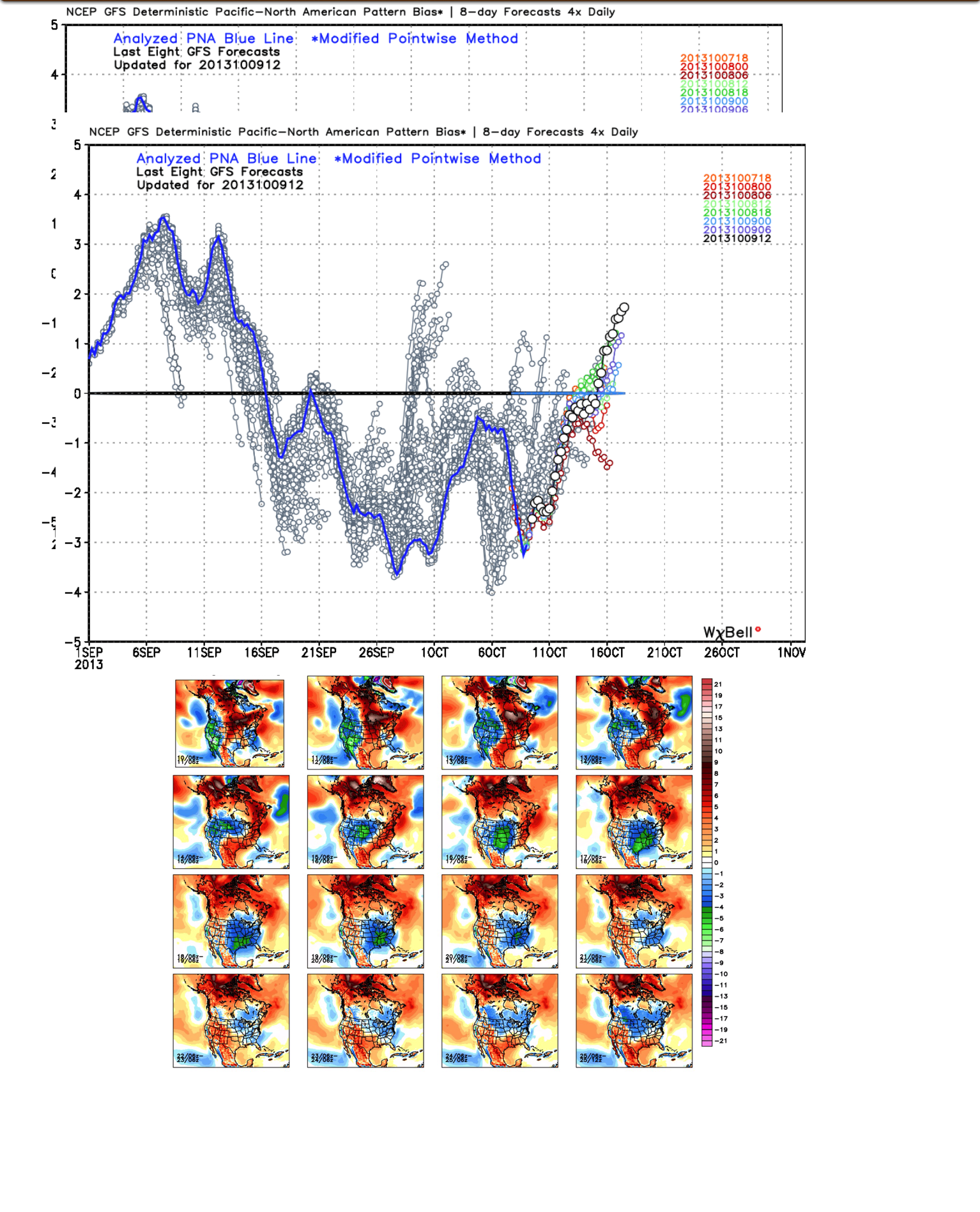
We also want to continue pointing out that with the PNA shifting back into the  positive, the stage is set for chilly air to hang around the region with more “staying power” as we move through October’s second half.  We’ve covered this in posts below and will continue to go over things as we move forward…  It’s time to certainly pull out those coats! 🙂

Permanent link to this article: https://indywx.com/friday-forecast-busier-times-ahead-in-the-good-ole-forecast-office/

Changes Brewing?

After an unseasonably cool summer, the pattern flipped to a warmer regime during the month of September.  That same warm pattern continues presently, but are changes brewing?

We note the PNA (Pacific North American pattern) is trending positive and this could help promote more of a sustained trough and associated cooler than normal pattern to wrap up October.  Would it be enough to offset the very warm first half of October?  Too early to tell.  However, I will say that with the PNA trending positive, it does suggest we’ll be looking at more sustained chilly conditions, as opposed to the “in and out” flirtations of cool air as of late.

The GEFS suggests a trough sets up shop across the eastern part of the country for the back half of October.

IMG_0889

Permanent link to this article: https://indywx.com/changes-brewing/