 Highlights:
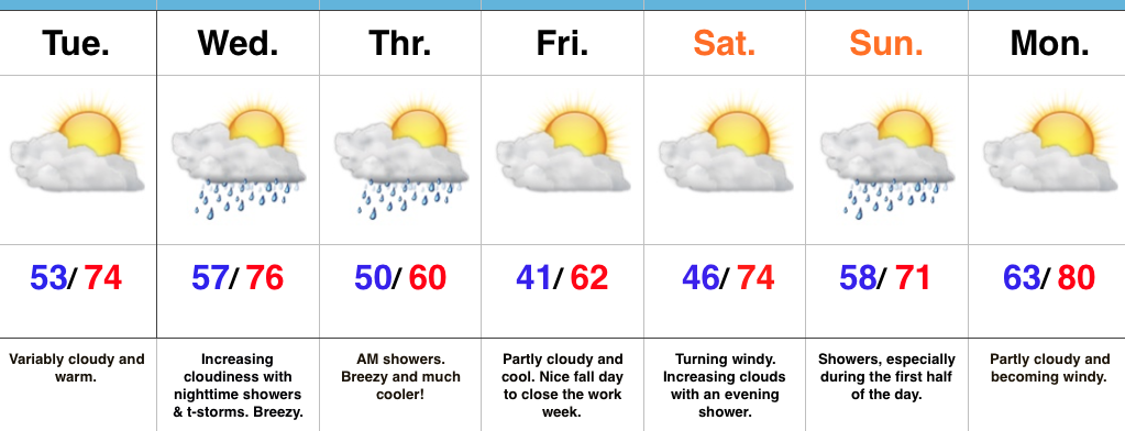
- Shower and storm chances increase Wednesday night
- Coolest air so far this season to close the work week
- Warm push of air early next week
Nice Today Before Wednesday Night Storms…Mid and high level cloudiness will continue to scoot through the Ohio Valley today. While we noted a few sprinkles during the predawn hours, the air remains dry and we should be rain-free today with increasing PM sunshine.
Wednesday will turn increasingly breezy as the day progresses and a cold front will help kick up scattered showers and thunderstorms Wednesday night into the early morning hours Thursday. Behind the front, the coolest air so far this season will press southeast and set us up for a chilly close to the week.
The cool air won’t stay around long as we flip our air flow back to the south over the weekend. Showers are a good bet Sunday followed by a gusty south wind and a summer-like high in the lower 80s Monday.
A couple of notes: It’s beginning to be that time of year again when we have to get used to the wind. As the jet continues to mature, storm systems will become more frequent as we go deeper into fall. Strong winds are a given and the increasingly busy nature of the pattern is a signal of changes brewing. While we’re still a couple weeks away from a wholesale pattern change, don’t be surprised if we undergo a rather dramatic flip in the pattern as October gives way to November. This sure doesn’t look like last year in any way, and, in fact, it’s easy to argue it’s the exact opposite when it comes to early season cold and potentially wintry weather…
Upcoming 7-Day Precipitation Forecast:
- Snowfall: 0.00″
- Rainfall: 0.50″ – 0.75″
