 Highlights:
- Early morning rain ends
- Cooler air arrives
- Warm Saturday
- Much cooler close to the weekend
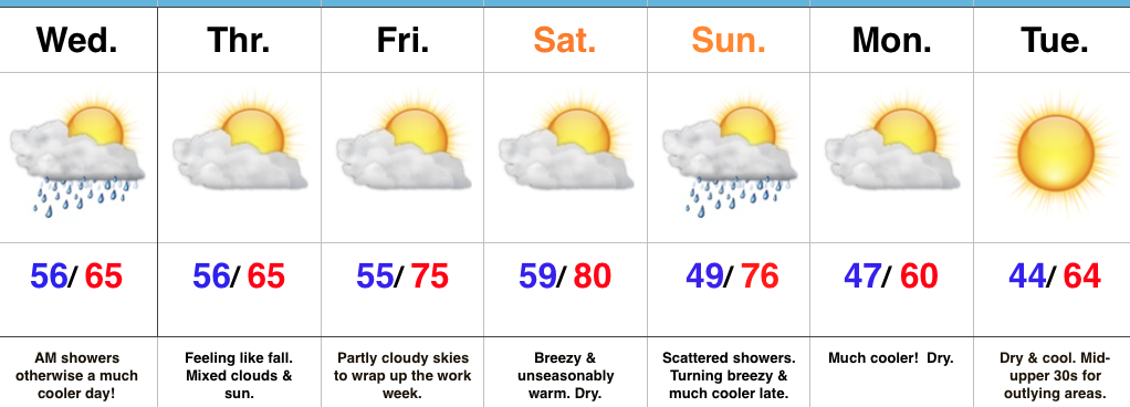
Buckle Up…Early morning showers and embedded thunder should press northeast of the region before the rush gets underway. All the same, expect damp roads on the way in to work and school Wednesday morning. Additionally, we’ll notice a much cooler feel to the day, including nearly steady or slowly falling temperatures. After a seasonable high Thursday, dry conditions and moderating temperatures will be with us to wrap up the work week.
Our next storm system will take aim on the region this weekend. Dry conditions will prevail Saturday, along with a gusty southwest wind that will help aid in boosting temperatures to around 80° (where’s that college football weather)?! That southwest (warm) wind will be in advance of an approaching cold front that will deliver scattered showers Sunday. Not everyone will get wet, but everyone will notice the much cooler close to the weekend. Temperatures will fall Sunday evening with a gusty north breeze.
Early next week will open dry and cool. – Just classic fall weather that most of us have come to know and love this time of year around these parts!
Looking ahead, there continue to be signs that point towards potentially a more significant shift in the weather pattern that would result in a rather dramatic cold transition to wrap up the month. More on this later.
Upcoming 7-Day Precipitation Forecast:
- Snowfall: 0.00″
- Rainfall: 0.25″ – 1.00″
