 Highlights:
- Wednesday powder
- Fresh batch of arctic air
- Messy late weekend storm
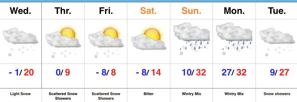
Snow Develops Wednesday Afternoon…Upper level energy will move across the region Wednesday and result in snow overspreading the northern half of the state (especially from Indianapolis and points north) during the afternoon and evening. While snowfall amounts won’t be particularly impressive (generally 1″ or less), roads will likely get slick in relative quick fashion prior to the evening drive. You’ll want to leave extra time on your evening commute home. Otherwise, blowing and drifting snow will develop tomorrow night into Thursday as fresh arctic air pours into the area.
Attention will shift to lake effect snow across northeastern portions of the state Thursday before another ripple of energy drops southeast and sparks additional snow showers across central parts of the state to wrap up the work week. Saturday will be dry and very cold.
Clouds will be on the increase overnight Saturday into Sunday morning and a mixed bag of precipitation will overspread the region Sunday PM. We still have a few more days to watch things unfold, but concern remains for an icy cocktail of sleet and freezing rain after a potential initial burst of snow. While warm air advection (WAA) will likely win out, we’re afraid it’ll be very difficult to warm the surface enough to prevent ice from becoming an issue Sunday afternoon into early Monday. Cold air will sweep back in here Monday evening into Tuesday with snow showers and gusty winds.
Upcoming 7-Day Precipitation Forecast:
- Snowfall: 1″ to 3″
- Rainfall: 0.10″
