Sunday Forecast: Turning More Active

Updated 09.15.13 @ 9:26a

Zionsville, IN After a cool and refreshing weekend, a more active weather pattern lies ahead for the upcoming week!

Capture

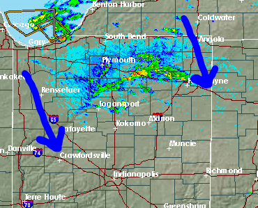
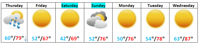
Finishing Up The Weekend Nicely:  It’s a chilly start to your day across central Indiana. We note several communities down into the 40s again this morning.  Certainly this weekend has gotten many into the fall mood (myself included).  We’ll finish up the weekend nicely with dry skies and highs reaching the middle 70s. It’ll be very pleasant for you tailgaters out there!  We’ll notice increasing cloudiness through the day and a broken line of showers (perhaps a rumble of thunder) will move through central Indiana tonight into the wee morning hours Monday. Rainfall numbers aren’t impressive with this weather maker, as most should see a tenth to a quarter inch of rain on average.

Dry and Pleasant: A dry, pleasant air mass will build in on Monday. Early clouds and any left over rainfall should exit during the morning hours with sunshine building in during the afternoon. Tuesday looks very nice with sunny skies and very comfy’ temperatures!

Turning More Active:  We’ll turn up the thermometer and humidity levels for the middle and latter portion of the week as our dominant air flow shifts around to the southwest in advance of our next (more significant) weather maker. With the increasing humidity, scattered showers and thunderstorms will return to the forecast as early as Wednesday and Thursday, with more widespread shower and thunderstorm activity expected as a cold front gets closer to the region. In fact, we think as much as one half to three quarters of an inch of rain is possible on Friday, in association with this cold front. As the front passes the region, cool high pressure will build back in setting the stage for another delightful, early fall like weekend!

Follow us on Twitter: @IndyWx

Friend us on Facebook: search IndyWx.com

Permanent link to this article: https://indywx.com/sunday-forecast-turning-more-active/

Wetter Pattern Looming?

Short term drought conditions continue to expand and worsen for many communities across central Indiana. From an agricultural stand point, negative impacts (slightly to moderately so) are being experienced on…

You must be logged in to view this content. Click Here to become a member of IndyWX.com for full access.  Already a member of IndyWx.com All-Access?  Log-in here.

Permanent link to this article: https://indywx.com/wetter-pattern-looming/

Short Term Update 5:34p: Another Line of Broken Showers?

We note radar trends and short-term model data tries to swing another quick-moving broken line of showers and embedded thunder through central Indiana this evening.

Radar as of 5:30p

radar

Short term model data continues to point to this broken line of showers and embedded thunder moving south and east with time as the secondary (more potent) cold front passes this evening.

Capture

Again, most stay dry, but don’t be surprised to see a quick-moving shower or clap of thunder later this evening.

Your updated 7-Day forecast can be found below, and remember you can follow us on Twitter and Facebook for continuous updates on the go!

Permanent link to this article: https://indywx.com/short-term-update-534p-another-line-of-broken-showers/

Friday Forecast: Grab The Jacket!

Updated 09.12.13 @ 4:59p

Zionsville, IN A series of cold fronts sweep the state tonight.  This will help usher in our first true taste of autumn for the season, just in time for another special football weekend ahead!  Don’t get used to the chilly conditions as resurgent heat, and better rain chances lie ahead. We discuss below!

Capture

Chilly Air Blows Into Town: A series of cold fronts are in progress of blowing through central Indiana. One is already through with another waiting in line. This secondary cold front packs some chilly air behind it and will result in temperatures in the upper 40s for many come morning.  Talk about stark contrast from heat indices in the 100s earlier this week!  We’ll note some instability-driven puffy cumulus clouds forming during the afternoon, but these will clear and give way to a calm, chilly night. Overnight lows Saturday morning will fall into the 30s for outlying areas.

Weak Cold Front Sunday: A weak cold front will lead to afternoon clouds and the threat of an isolated thunderstorm Sunday afternoon/ evening. We think 80-90% of the coverage area remains rain-free for now, but we’ll keep an eye on things and update accordingly.  This boundary will be responsible for keeping things dry and pleasant through early next week.

The Heat Returns: While we don’t anticipate anything nearly as brutal as this past week’s stretch of heat, the thermometer will flirt with the 90 degree mark once again come Wednesday.  Strong southwest winds will blow a warmer, more humid brand of air north bound for mid week and have overnight lows only falling into the lower 70s. A cold front will approach the region late next week, leading to what appears to be some scattered to numerous showers and thunderstorms by next Thursday.

Follow us on Twitter: @IndyWx

Friend us on Facebook: search IndyWx.com

Permanent link to this article: https://indywx.com/friday-forecast-grab-the-jacket/

Thursday Forecast: Big Time Cool Down To Close The Week!

Updated 09.11.13 @ 10:06p

Zionsville, IN After three brutally hot late summer days, I know most are looking forward to a big time change for the cooler as we close out the work week and head on into the weekend!  We talk temperature changes, slim chances for some badly needed rainfall, and another stretch of heat next week!

7day091113

Cold Front Blows Through Later This Morning: A strong cold front will usher in a true taste of autumn just in time for another special football weekend ahead!  We bracket the wee morning hours through late morning for the chance of a shower or embedded rumble of thunder as the cold front blows through central Indiana.  That said, we’re only looking at a broken line of precipitation and don’t think every neighborhood gets wet.  Those that do see rain, don’t look for anything too terribly impressive, with most precipitation totals under two tenths of an inch. Winds will then shift out of the northwest and gust upwards of 20 MPH during the evening, helping the drastically cooler air settle in. Temperatures will actually fall during the afternoon, after early highs in the upper 70s.

Brilliant, Fall-Like Late Week: Despite a few puffy cumulus clouds Friday, expect dry conditions extending into Saturday with lots of sunshine. Temperatures will run roughly ten degrees below normal. In fact, Saturday morning will be particularly chilly, especially considering the simmering heat earlier this week. Some outlying communities will likely fall into the upper 30s. Highs both Friday and Saturday will only make it into the upper 60s. – Sounds like a perfect weekend to grab a Pumpkin Spice Latte prior to kickoff of your favorite football team!

Sunday Shower? A weak cold front will slide through the region Sunday evening. Clouds will increase with this boundary and we’ll keep an eye on precipitation chances as we move forward. That said, for now, we only think a widely scattered shower is possible Sunday. Most stay dry.

Resurgent Warmth Next Week: As we’ve been saying for weeks, we’re still in a warm pattern, overall, and don’t see any significant changes until potentially late in the month (say the last 5-7 days). Ridging rebuilds by the middle part of next week and moderating temperatures will ensue. We anticipate highs flirting with the 90 degree mark by Wednesday.

Follow Us On Twitter: @IndyWx

Friend Us On Facebook: search IndyWx.com

Permanent link to this article: https://indywx.com/thursday-forecast-big-time-cool-down-to-close-the-week/