|
Tue.
|
Wed.
|
Thr.
|
Fri.
|
Sat.
|
Sun.
|
Mon.
|
|

|
|

|
|
|
|
|
|
56/ 70
|
46/ 73
|
58/ 82
|
52/ 68
|
44/ 55
|
41/ 59
|
49/ 69
|
Cooler Today And Not As Bright…The plentiful sunshine and warm temperatures we’ve enjoyed for the past 7 days+ will shift towards a more unsettled time of things in the days ahead. Today is just the beginning of a 1-2 punch of cooler air impacting the region. A cold front is moving through central Indiana this morning and will result in more cloudiness today (late day brightening expected) along with a north wind shift and cooler conditions. Lows tonight will fall into the 40s for most central Indiana communities. Wednesday will be delightful- lots of sunshine and seasonable early autumn air.
Strong Cold Front Blasts Through…We’ll cloud things back up through the day Thursday and introduce showers and thunderstorms into your forecast Thursday night into Friday. A couple of gusty thunderstorms are possible as the front moves through. MUCH cooler air will pour into the area Friday afternoon and evening on gusty northwest winds.
Chilly Weekend Setting Up…The weekend will certainly require those long sleeve shirts and jackets as a MUCH cooler autumn air mass settles over the Mid West and Ohio Valley region. Most of Saturday will likely feature mostly cloudy skies, gusty northwest winds, and sprinkles before late day clearing begins. Note the unseasonable chill in place- only middle 50s Saturday. More sunshine is expected Sunday.
Upcoming 7-Day Precipitation Forecast:
- 7-Day Rainfall Forecast: 0.50″ – 1.00″
- 7-Day Snowfall Forecast: 0.00″
Permanent link to this article: https://indywx.com/cooler-today-but-a-bigger-cool-shot-arrives-friday/
-
Filed under 7-Day Outlook, Autumn, Canadian Model, Forecast, Forecast Discussion, Forecast Models, GFS, Rain, T-storms, Unseasonably Cool Weather, Unseasonably Warm, Weekly Outlook
-
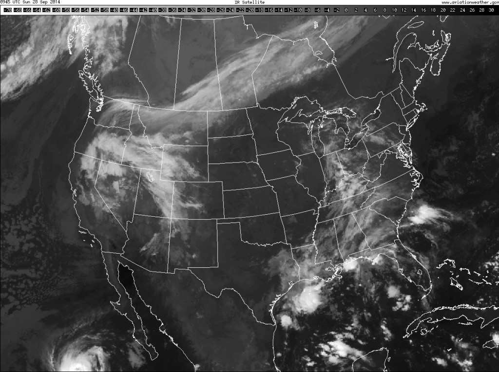
September 28, 2014
– What a beauty of a Sunday evening underway! Temperatures across the Ohio Valley and Mid West are running 15°-20° above where we’d expect them. The recent dry, warm stretch…
You must be logged in to view this content. Click Here to become a member of IndyWX.com for full access. Already a member of IndyWx.com All-Access? Log-in here.
Permanent link to this article: https://indywx.com/weekly-outlook-pleasant-but-big-changes-hit-late-week/
Colts v. Titians Forecast Prepared For:
The Indiana Sports Report
09.28.14
Happy game day Colts fans! High pressure will remain firmly entrenched across the Ohio Valley region and this will supply tailgaters with ideal early fall weather. Despite some mid and high level cloudiness early, sunshine and unseasonably warm temperatures can be expected with a light breeze. Visit IndyWx.com for “Indy’s Behind The Scenes Weather!”
|
Tailgate Weather
|
Kickoff Weather
|
Heading Home
|
| Mid and high level clouds, otherwise partly cloudy. |
Partly cloudy |
Mostly clear |
| Temp: 60-70 |
Temp: 78-80 |
Temp: 81-83 |
| Wind: NE 5 MPH |
Wind: NE 5 MPH |
Wind: NE 5 MPH |
| Precip: 0.00” |
Precip: 0.00” |
Precip: 0.00” |
Morning mid and high level cloudiness should give way to increasingly sunny conditions this afternoon.
Permanent link to this article: https://indywx.com/warm-indysportsreport-com-colts-forecast/
|
Sat.
|
Sun.
|
Mon.
|
Tue.
|
Wed.
|
Thr.
|
Fri.
|
|
|
|
|
|
|
|
|
|
56/ 80
|
55/ 81
|
58/ 80
|
55/ 78
|
55/ 78
|
58/ 81
|
55/ 69
|
Warm; Sun-Filled Weekend…High pressure will anchor itself over the eastern Great Lakes and remain close enough to our region to supply continued sunny skies and dry conditions. We’ll also continue to enjoy a much warmer than normal feel of things (normal highs this time of year are in the lower 70s). Enjoy, because this time next week will look and feel MUCH different…
On Cruise Control…No reason to waste many pixels on the early and mid week stretch. Dry skies and warm air will be the rule up until Friday.
Strong Autumn Cold Front…A strong cold front will move into the area Friday and crash our perfect weather party. Look for increasing clouds Thursday along with showers and thunderstorms Friday. Temperatures will crash behind the boundary and set up a weekend that feels more like November than October.
Upcoming 7-Day Precipitation Forecast:
- 7-Day Rainfall Forecast: 0.50″ – 0.75″
- 7-Day Snowfall Forecast: 0.00″
Jason Burton sent in this beautiful sunrise shot from Union City Friday morning! Thanks, Jason!


Fan of calm, warm weather? Enjoy this weekend. A look at next weekend shows a drastically different look…
Permanent link to this article: https://indywx.com/enjoy-this-weekend-changes-coming/
We’re gearing up for another big evening of high school football across central Indiana and we’re going to be blessed with yet more ideal weather conditions. Look for dry skies…
You must be logged in to view this content. Click Here to become a member of IndyWX.com for full access. Already a member of IndyWx.com All-Access? Log-in here.
Permanent link to this article: https://indywx.com/another-dry-evening-for-your-indysportsreport-com-high-school-football-forecast/


