More Heavy Rain Inbound Tonight…
You must be logged in to view this content. Click Here to become a member of IndyWX.com for full access. Already a member of IndyWx.com All-Access? Log-in here.
You must be logged in to view this content. Click Here to become a member of IndyWX.com for full access. Already a member of IndyWx.com All-Access? Log-in here.
We’re off to a cloudy and cool start, but at least things are dry this morning. The frontal boundary that delivered the rain and flooding to central IN Tuesday has…
You must be logged in to view this content. Click Here to become a member of IndyWX.com for full access. Already a member of IndyWx.com All-Access? Log-in here.
 Highlights:
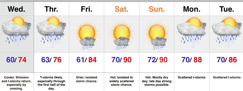
A frontal boundary will slip south of central IN later this evening and take most of the heavy rain and storms south tonight into a good chunk of Wednesday. However, the boundary will return north Wednesday evening in response to an area of surface low pressure moving northeast out of the lower and middle MS River Valley. This will return the focus of showers and heavier thunderstorms for our region Wednesday evening into the first half of Thursday. Similar to that of today, locally heavy rainfall is a good bet at times.
The area of low pressure will track east Thursday afternoon and take most of the moisture with it. We’ll forecast drier times to wrap up the work week along with rising temperatures. While we can’t shake weekend storm chances, Friday through Sunday will be drier, overall, when compared to the next couple days. With the heat and humidity around, a few strong to severe storms are possible- particularly Sunday afternoon. We’ll keep an eye on things.
Scattered, “splash and dash,” coverage of storms returns early next week.
Upcoming 7-Day Rainfall Forecast: 2″ – 2.5″
We hope this finds you coming off an enjoyable Independence Day with friends and family! As we look at the snap shot of the opening to July we see that…
You must be logged in to view this content. Click Here to become a member of IndyWX.com for full access. Already a member of IndyWx.com All-Access? Log-in here.
You must be logged in to view this content. Click Here to become a member of IndyWX.com for full access. Already a member of IndyWx.com All-Access? Log-in here.