Quick video update on our thinking tonight, as well as a look at the weekend…
You must be logged in to view this content. Click Here to become a member of IndyWX.com for full access. Already a member of IndyWx.com All-Access? Log-in here.

Jan 28
Quick video update on our thinking tonight, as well as a look at the weekend…
You must be logged in to view this content. Click Here to become a member of IndyWX.com for full access. Already a member of IndyWx.com All-Access? Log-in here.
Permanent link to this article: https://indywx.com/wednesday-evening-thoughts-2/
Jan 28
 Making Up For Lost Time…Many snow lovers out there have been disappointed by the lack of the white stuff winter to date. The cool thing is that the next 7-10 days (most likely longer) will offer up multiple opportunities to serve up accumulating snow.
First things first and that’s today- look for bright sunshine and a frosty start. Temperatures will “warm” to just under seasonal levels this afternoon. A fast moving storm system will scoot through here late tonight and Thursday morning with light rain, possibly transitioning to light snow showers before precipitation ends Tuesday (not a big deal). Far eastern areas may experience a brief period of light freezing rain or light sleet during the onset of precipitation, but things should switch over to light rain rather rapidly even for you. We’ll turn dry and cold to wrap up the work week.
All eyes are on the weekend as a storm system moves towards the region. We have a ways to go and we’ll have to fine tune the details over the next few days, but this has potential to be the most widespread significant wintry event of the season. Stay tuned. MUCH colder air will punch in here early next week and may set the stage for more wintry “mischief” by the middle of next week.
 IU at Purdue: 9p tonight
Good news is that for those driving to West Lafayette tonight, you should be dealing with dry conditions. Precipitation chances will begin to go up as we near 11p, or after, for western portions of the state.
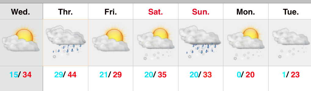
Upcoming 7-Day Precipitation Forecast:
Permanent link to this article: https://indywx.com/now-this-is-more-like-it-2/
Jan 27
The video goes into the detail around our weekend thoughts. Is a winter storm brewing?
You must be logged in to view this content. Click Here to become a member of IndyWX.com for full access. Already a member of IndyWx.com All-Access? Log-in here.
Permanent link to this article: https://indywx.com/weekend-thoughts/
Jan 27
Forecast models have been printing out wintry solutions for the upcoming weekend- particularly Saturday night through Super Bowl Sunday.
The GFS 500mb charts between 12z Monday and this morning show the key with this potential storm. Note the difference between yesterday (top) and today (bottom). The GFS model brings more energy out and the result is a stronger storm system.

 Timing between cold and moisture associated with storm systems has been the important missing link this winter with bigger storms. Does that trend continue this weekend? Snow lovers hope not…
A key ingredient that has been missing in the past is a big area of high pressure north of the region supplying cold air as surface low pressure tracks in a favorable position for wintry precipitation. Models do suggest not only renewed arctic high pressure building down the Plains region Sunday into Monday, but also a 1040mb high over the northern Lakes region. This would help go a long way in keeping cold air flowing into the region.
What about the sensible weather here?! Keeping in mind that this is still an event 5 days out….. The GFS model suggests mostly a snow event north-central, but also brings in a wintry mix of icy precipitation and rain across the southern half of the state. The Canadian forecast model (not shown here) is more suppressed and leads to an accumulating weekend snow event across the region and targets southern portions of the state for heaviest snowfall. The European model is the most “ideal” scenario for central Indiana snow lovers and leads to a significant snow event across the heart of the state.
Note the European forecast model track a wave of low pressure in an ideal location for heavy snow across central Indiana before intensifying and hammering the Northeast region.


We’ll continue to keep a close eye on this developing situation. Stay tuned….
Permanent link to this article: https://indywx.com/keeping-an-eye-on-the-weekend/
Jan 26
 Slick Travel This Morning; More Light Snow This Evening…Rain changed to snow in and around Indianapolis between 5-6 Sunday evening. The changeover occurred earlier just north and northeast of the city where anywhere from a quarter inch of snow fell to as much as 3 inches in and around the Muncie area. The big problem last night and this morning is the combination of moisture freezing on the roadways, light snow, and strong and gusty winds. Area roadways have been reported slick with numerous accidents. Take it slow this morning.
Most of today will be quiet and dry, but light snow will build into the state later this evening into tonight. We target areas along and west of I-65 for the greatest opportunity of accumulating a dusting to half an inch of snow tonight. Sunshine returns Tuesday before a mid week system brings light rain Wednesday night into Thursday. Light rain will diminish as light snow Thursday.
Colder air will be with us as we wrap up the work week before our next storm system impacts the Hoosier state over Super Bowl weekend. We forecast increasing clouds Saturday with snow developing Saturday night into Sunday.
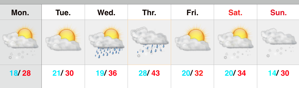
Upcoming Precipitation Forecast:
Permanent link to this article: https://indywx.com/light-snow-impacts-some-this-evening/
