Stay Weather Aware…As we type this central Indiana is enjoying a brief lull in what’s been a rather active day, complete with strong to severe thunderstorms. Latest scans of our short term forecast models suggest the quiet times don’t last long as more thunderstorms rumble into central Indiana during the overnight hours. Hail, vivid lightning, and additional flooding is possible with overnight/ early Thursday morning storms.
Attention then shifts to the possibility of a rather significant severe weather outbreak Thursday afternoon into Thursday night, particularly if we get rid of morning convection and cloud debris. Tonight’s data would suggest we do clear things out Thursday afternoon and this would add “fuel to the fire” for potential severe weather Thursday night. All modes of severe weather are in play Thursday night, including large hail, damaging straight line winds, and tornadoes. Flash flooding will also remain a concern as some areas have accumulated more than 3″ of rain today alone.
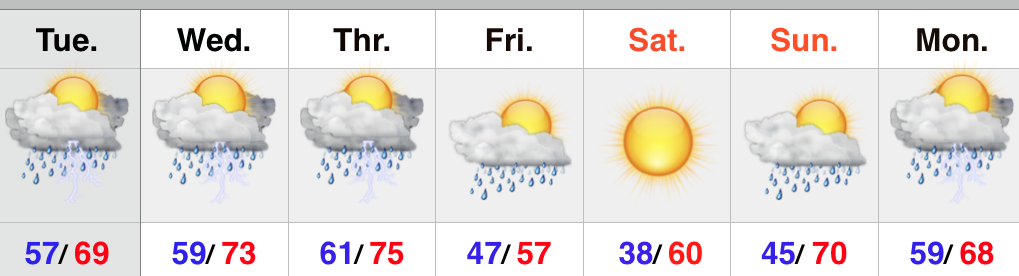
The cold front and associated surface low responsible for Thursday’s severe weather will sweep the state Friday and usher in a much cooler and breezy regime Friday evening that will continue into Saturday. Sunshine returns in full force Saturday and Sunday. Perfect timing, huh?!
Enjoy that sunshine and calmer times of the weekend as rainy and stormy conditions return quickly early next week. All-in-all, the overall theme remains a warm, wet, and stormy one.
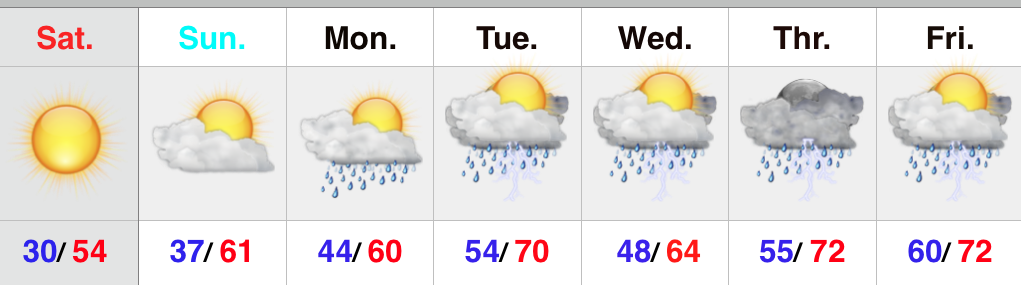
Upcoming 7-Day Precipitation Forecast:
- 7-Day Rainfall Forecast: 2.50″ – 3.00″
- 7-Day Snowfall Forecast: 0.00″