 Highlights:
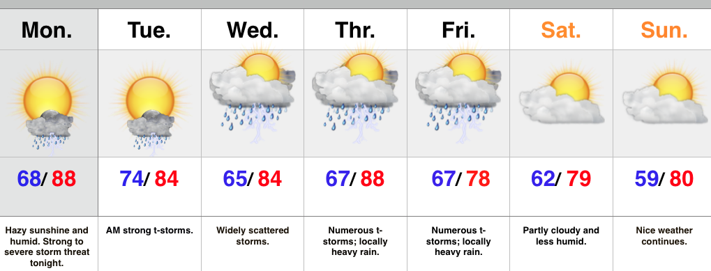
- Strong to severe t-storm potential tonight-Tuesday morning
- More widespread rain and storms late week.
- Much drier and less humid this weekend.
We’re off to a warm, humid, and hazy start to the day and most of your Monday will be a dry one. That said, all eyes will be to our NW as we eye thunderstorm complexes that will gain strength this afternoon and evening before tracking southeast. One storm complex will likely target the northern half of the state late tonight and on into the wee morning hours Tuesday. Damaging wind, vivid lightning, and localized flooding are of greatest concern.
Typical “splash and dash” storm coverage will be with us during the mid week period before a cold front delivers more widespread rain and storms for late week. Locally heavy rain will accompany this front. As of now, the timing couldn’t be better. We anticipate a much drier regime to blow into town behind the cold front, setting the stage for a beautiful weekend.
Upcoming 7-Day Rainfall Forecast: 2″ – 2.5″
Permanent link to this article: https://indywx.com/strong-to-severe-storms-possible-tonight/
Monday and Tuesday will serve to offer up a continuation of storm chances- some of which may reach strong to severe levels. Most of both days will be dry, but…
You must be logged in to view this content. Click Here to become a member of IndyWX.com for full access. Already a member of IndyWx.com All-Access? Log-in here.
Permanent link to this article: https://indywx.com/sunday-evening-rambles/
 Highlights:
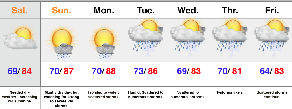
- Dry day coming with increasing sunshine
- Strong to severe storms possible Sunday
- Back to an unsettled pattern most of next week
The remnants of Bill continue to push east and we’re now enjoying a drier northeast wind that will shift to the northwest with time by evening. A nice day is coming, friends!
We’ll watch a thunderstorm complex to our NW tonight and forecast models handle this complex differently. We’re going with the idea that the complex will weaken moving into central IN during the overnight, but a clap of thunder is certainly possible late tonight/ early Sunday. The radar will look very impressive to our NW by evening. Additional afternoon/ evening storms may develop Sunday and these could become strong to severe, as well.
Better coverage of showers and thunderstorms will develop as we progress into next week.
Upcoming 7-Day Rainfall Forecast: 2″ – 2.5″
Permanent link to this article: https://indywx.com/needed-dry-time-coming/
-
Filed under Bill, Flooding, Forecast Discussion, Heavy Rain, Rain, Severe Weather, Summer, T-storms, Tropics, Unseasonably Cool Weather, Weather Rambles
-
June 19, 2015
1.) A wet day is ahead for central & southern IN as the combination of a stalled front and Bill’s remnant moisture work in. Rain has already been heavy just…
You must be logged in to view this content. Click Here to become a member of IndyWX.com for full access. Already a member of IndyWx.com All-Access? Log-in here.
Permanent link to this article: https://indywx.com/friday-morning-rambles-2/
-
Filed under Bill, Flooding, Forecast, Forecast Discussion, Forecast Models, Heavy Rain, Severe Weather, T-storms, Tropics, Weather Videos
-
June 18, 2015
You must be logged in to view this content. Click Here to become a member of IndyWX.com for full access. Already a member of IndyWx.com All-Access? Log-in here.
Permanent link to this article: https://indywx.com/thursday-evening-video-update-3/

