Quiet, Cold Pattern Turns More Active Next Week…
You must be logged in to view this content. Click Here to become a member of IndyWX.com for full access. Already a member of IndyWx.com All-Access? Log-in here.
You must be logged in to view this content. Click Here to become a member of IndyWX.com for full access. Already a member of IndyWx.com All-Access? Log-in here.
No need for model data or fancy graphs with this post, but instead we just wanted to level set with you on where we think we’re heading as we rumble…
You must be logged in to view this content. Click Here to become a member of IndyWX.com for full access. Already a member of IndyWx.com All-Access? Log-in here.
December has been a warm and wet month for the region. In fact, it’s been so warm, some have labeled this “October in December.” Snow and ice cover…
You must be logged in to view this content. Click Here to become a member of IndyWX.com for full access. Already a member of IndyWx.com All-Access? Log-in here.
 Highlights:
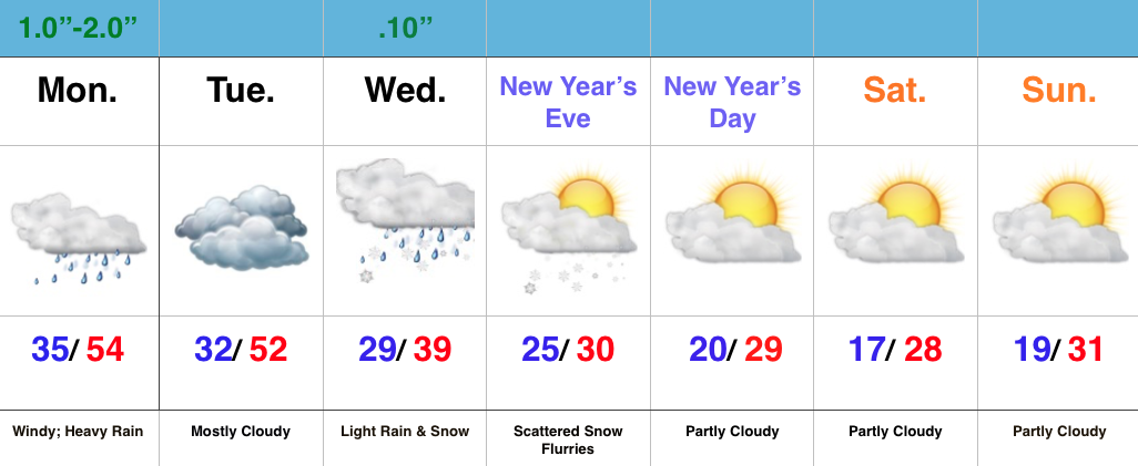
Strong Winds And Flood Threat Remains…What an active morning across central IN! Northeast winds are already gusting around 40 MPH with periods of heavy rain this morning. Across our northern tier of counties (mainly north of a line from LAF to KOK) freezing rain and sleet is the issue this morning with temperatures below freezing.
Periods of heavy rain will continue today, and we also note the threat of embedded thunder (damaging wind risk) this evening, bracketed between the hours of 6p-8p.
 Temperatures will remain cold and raw through most of the day before we see a late day rally briefly into the lower to middle 50s. It’ll be another day with a tight temperature gradient across the state, as northern IN will struggle to make it much above freezing, while southern IN approaches the upper 60s this evening.
Midnight highs Tuesday can be expected before temperatures crash.
We’ll then set our eyes towards a weak wave of low pressure that looks to deliver a light mixed bag of precipitation Wednesday morning. The freezing line will run through the central part of IN and a mixture of light snow and light rain can be expected. MUCH colder air flows into the state behind this system and sets the stage for a cold open to 2016.
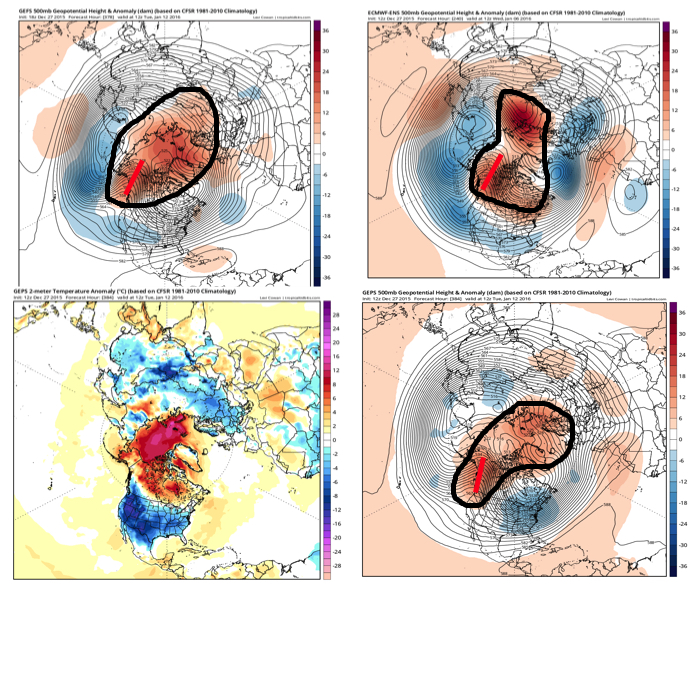
 Forecast models continue to show an expected pattern shift to all-out sustained cold and wintry conditions for mid and late winter. Note the W NA ridging developing. Additionally, blocking and a negative AO develop as mid January nears. Think this is the year without a winter? Better think again, my friends.
Saturday will dawn dry across the region, but that will quickly begin to change as morning progresses into afternoon. Moisture is streaming north and a “wavy” frontal system will remain…
You must be logged in to view this content. Click Here to become a member of IndyWX.com for full access. Already a member of IndyWx.com All-Access? Log-in here.