The heat & humidity is the story currently, but short term models develop showers and strong to severe thunderstorms over the northern half of the state this evening. Futurecast valid…
You must be logged in to view this content. Click Here to become a member of IndyWX.com for full access. Already a member of IndyWx.com All-Access? Log-in here.
Permanent link to this article: https://indywx.com/watching-for-more-evening-storms/
 Highlights:
- Hot and humid today
- Scattered strong to severe storms Sunday
- Unsettled early next week
After another wild evening of storms and flooding across central IN it’s good to see the sun shining this morning. We think today will be a mostly dry day across the region, but will be plenty hot and humid. Certainly plan to take frequent breaks and drink plenty of water if you’re planning any lengthy outdoor activities today.
The break in the wet, stormy weather won’t last long as scattered to numerous thunderstorms return Sunday, including more hefty rainfall totals possible. A few storms may become severe with damaging wind and large hail.
Early next week will remain unsettled, but we’re keeping our fingers crossed for a drier regime by the middle of the week.
Upcoming 7-Day Rainfall Forecast: 2″ – 2.5″
Permanent link to this article: https://indywx.com/hot-stormy-weather-returns-sunday/
-
Filed under AG Report, Forecast, Forecast Discussion, Forecast Models, Heavy Rain, Long Range Discussion, Rain, Summer, T-storms, Tropics, Typhoon Rule, Unseasonably Cool Weather, Unseasonably Warm
-
July 16, 2015
Right off the bat, we tend to lean more in the direction of the 12z GFS and its’ associated cooler look next week, rather than the warm European. It’s a…
You must be logged in to view this content. Click Here to become a member of IndyWX.com for full access. Already a member of IndyWx.com All-Access? Log-in here.
Permanent link to this article: https://indywx.com/at-odds-with-some-of-the-modeling-in-the-mid-long-range/
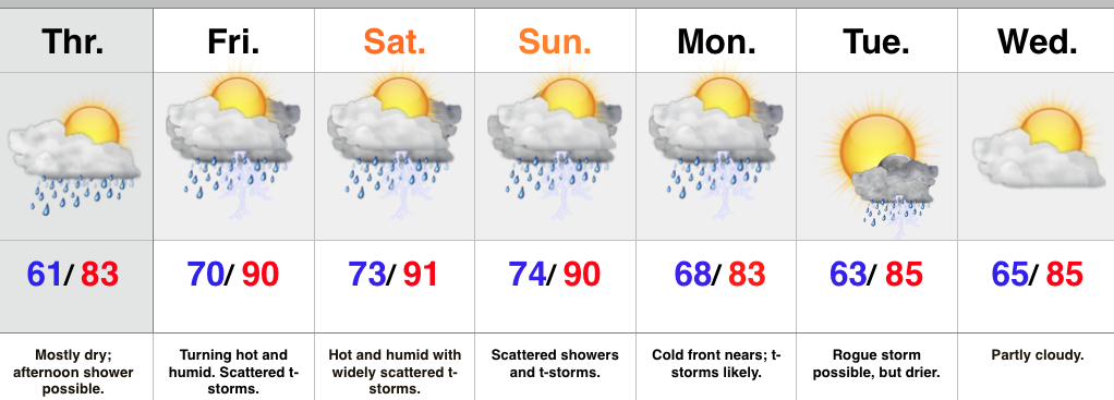 Highlights:
- Afternoon light shower possible
- Very humid, tropical feel this weekend as things heat up
- Splash and dash weekend storms
- T-storms likely with a cold front Monday
We’re off to a pleasant start today, but clouds will increase this afternoon with a light shower possible, particularly from the city and points north. Most of today will be dry.
The big story this weekend will be a much more humid feel. While it’ll be hot, it won’t be anything out of the ordinary for late July around these parts. That said, factor in a dew point in the lower to middle 70s and it’ll feel extremely oppressive. A warm front will pass Friday morning with a thunderstorm threat, and then we’ll also mention a widely scattered thunderstorm during the afternoon/ evening through the weekend.
A cold front will move in Monday with more widespread showers and thunderstorms, along with a return to “average” temperatures by the middle of next week.
Upcoming 7-Day Rainfall Forecast: 1″-1.5″
Permanent link to this article: https://indywx.com/nice-now-but-big-ticket-humidity-on-the-way/
You must be logged in to view this content. Click Here to become a member of IndyWX.com for full access. Already a member of IndyWx.com All-Access? Log-in here.
Permanent link to this article: https://indywx.com/wednesday-evening-video-update-3/

