Pick Of The Weekend Is Today; Taste Of Early Fall Coming…

Screen Shot 2015-08-08 at 9.21.27 AMHighlights:

  • Half-n-half weekend
  • Early week storms
  • Fall preview coming

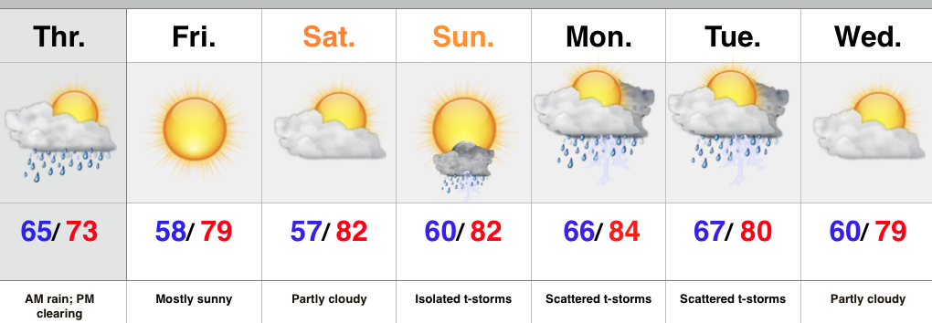
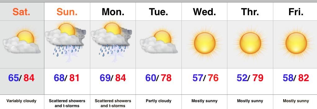
The weekend is off to a pleasant start- both from a temperature and humidity perspective, but also with current sky conditions across the area.  Expect periods of mid and high level cloudiness to increase later today.  We also note some of our shorter term modeling trying to push light rain into the picture by evening, but think the air mass will take some time to moisten up before we see much in the way of rain.  Most of this should dissipate moving into western IN this evening.

The second half of the weekend will provide much better chances of showers and embedded thunder.  In fact, we expect a couple waves of showers and thunderstorms Sunday.  It won’t rain the entire time, but keep the umbrella and rain gear handy.  Thunderstorm chances will continue as we open the new work week before a big push of cooler and drier air engulfs the region heading into mid week.  An early fall preview will settle in Tuesday evening and have things feeling mighty nice around these parts for the rest of the week.

Upcoming 7-Day Rainfall Forecast: 0.50″ – 1.00″

Permanent link to this article: https://indywx.com/pick-of-the-weekend-is-today-taste-of-early-fall-coming/

Awesome Close To The Work Week; Weekend Thoughts…

Thursday’s rain is now long gone. Heaviest rains fell south as expected. (Numbers below are only through 24 hours ago).    Many reporting sites across central Indiana are returning numbers…

You must be logged in to view this content. Click Here to become a member of IndyWX.com for full access.  Already a member of IndyWx.com All-Access?  Log-in here.

Permanent link to this article: https://indywx.com/awesome-close-to-the-work-week-weekend-thoughts/

Wet Start; Not A Bad Finish…

Screen Shot 2015-08-05 at 11.07.16 PMHighlights:

  • Wet start today
  • Beautiful close to the week
  • Storms return early next week
  • No oppressive heat or humidity in the picture

Low pressure will track east through the lower Ohio Valley today and help spread widespread rain up to the I-70 corridor this morning.  Periods of heavy rain can be expected downstate.  Thankfully rain won’t stay around all day and we should get into clearing later this afternoon and evening as drier air wins out from northwest to southeast.  This will set up a beauty of a close to the work week with nice weather continuing into the weekend.

Moisture will return early next week and we’ll introduce storms into the picture as early as Sunday afternoon, but particularly Monday and Tuesday before drier, more refreshing air returns for mid week.

Upcoming 7-Day Rainfall Forecast: 1″ – 1.5″ (heavier south)

Permanent link to this article: https://indywx.com/wet-start-not-a-bad-finish/

Wednesday Morning Update…

Good morning and happy Wednesday! Forecast models continue to provide a bit of a headache concerning our developing weather situation, but here’s our best take moving forward: The morning is…

You must be logged in to view this content. Click Here to become a member of IndyWX.com for full access.  Already a member of IndyWx.com All-Access?  Log-in here.

Permanent link to this article: https://indywx.com/wednesday-morning-update/

Model Consensus Is South With Thursday Rain, Except The High-Resolution NAM…

Mid and high level cloudiness continue to drift into the state this evening and we note some rain and storms downstate.  Across central Indiana, all-in-all it’s a very pleasant evening, including very comfy temperatures and humidity levels for early August.

Screen Shot 2015-08-04 at 6.35.54 PM


Model consensus today has been to shift the axis of heavy rain across southern Indiana Wednesday night and Thursday, including some locally heavy totals with flooding possible.

Screen Shot 2015-08-04 at 6.36.26 PMWe show the GFS above and we note the European, NAM, and Canadian all agree with the overall idea of heaviest rain across southern Indiana and points south.

Just as we were beginning to get all modeling onboard with the southern shift, the latest high-resolution NAM has shifted back north rather considerably.  Note the difference in rainfall totals expected from the high resolution NAM just from the 12z run to the latest 18z run.

Screen Shot 2015-08-04 at 6.44.49 PM


Screen Shot 2015-08-04 at 6.36.59 PM

No doubt the high resolution NAM is an anomaly, but we also can’t totally discard this solution just yet either based off the longer term projections and relative consistency just a couple days ago.  The higher resolution models can handle these type systems better at times so we’ll keep a close eye on things.

Confidence should increase rather dramatically with tonight’s model runs and we’ll be up to watch those trickle in.

Permanent link to this article: https://indywx.com/model-consensus-is-south-with-thursday-rain-except-the-high-resolution-nam/