Updated 03.19.24 @ 5:34a It’s a cold start to the day across central IN, but this time of year, especially with enough sunshine, we can warm-up nicely. That’ll be the…
You must be logged in to view this content. Click Here to become a member of IndyWX.com for full access. Already a member of IndyWx.com All-Access? Log-in here.
Permanent link to this article: https://indywx.com/video-turning-gusty-later-today-damp-close-to-the-work-week-and-looking-ahead-to-a-chance-of-severe-weather-early-next-week/
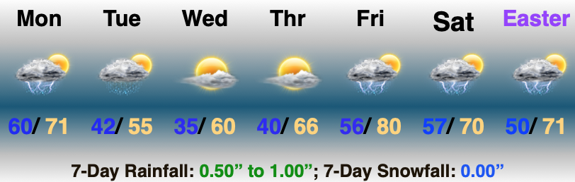
The story to open the work week will be a quiet one. For a change, we’re talking about a chilly air mass settling overhead. That colder air will also feature a return of drier times.
Despite a few scattered light snow showers today, we’ll stay on the dry side until Friday.
Multiple hard freezes can be expected this week. Tuesday morning will once again feature lows deep into the 20s area-wide.
The good news? Sunshine and calm conditions can be expected during the majority of the week ahead.
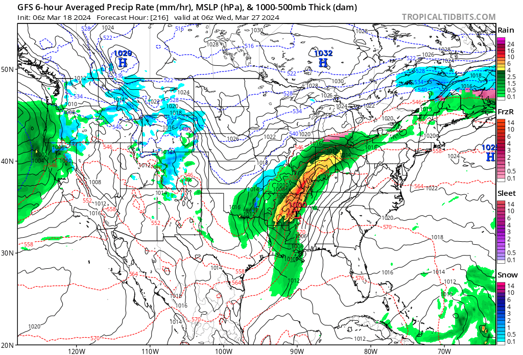
That will all change by Friday as a couple low pressure systems team up to return unsettled weather to our region. Friday looks wet and chilly as of now. Rain won’t be heavy, but more of a nuisance. It’ll be a good day to hunker down and watch Day 2 of the tourney.
Though Friday won’t feature a significant storm system, it will signal a change for a more active Week 2. Heavier rain and the possibility of stronger storms can be expected next week and we’ll have more details on this as we navigate the coming days.
Updated 03.17.24 @ 8:10a The theme for the bulk of the week ahead will be both cooler and drier. A few mornings will feature a hard freeze, including overnight lows…
You must be logged in to view this content. Click Here to become a member of IndyWX.com for full access. Already a member of IndyWx.com All-Access? Log-in here.
Indianapolis is running right at average month to date from a rainfall perspective (1.78”).
We’re transitioning to a much drier pattern in the week ahead as a cooler, Canadian airmass dominates (for a change).
Several hard freezes (mid-upper 20s) are on tap in the upcoming 7-10 day period: Monday/ Tuesday morning and again late next week/ next weekend.
Cooler? Yes, but I still don’t see anything overly cold on the horizon as we navigate the next couple of weeks.
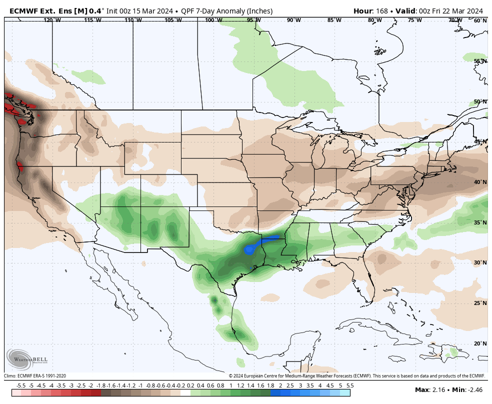
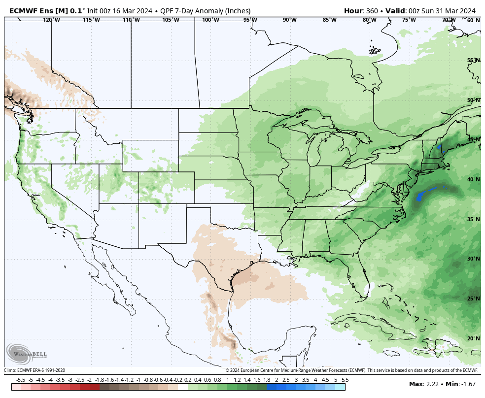
What’s more notable is the shift in the precipitation pattern over the next few weeks. The dry Week 1 (now) transitions to a significantly wetter and more active look Week 2 (below).
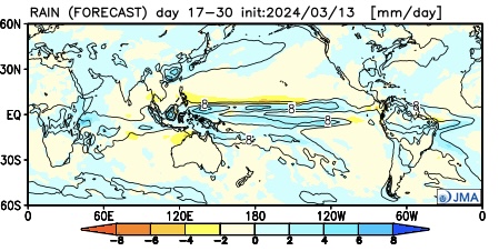
The JMA also sees the wetter regime.
This is forecast to continue in the Weeks 3/4 timeframe.
Continues to back up the idea of an active (wet) and stormy (more in the way of severe weather) spring as a whole.
Down the road, an eventual move into a hot, dry (compared to normal) summer may loom. (Yet one that is very active from a tropical perspective, continuing into the fall). More on that in the coming weeks…
Updated 03.15.24 @ 7:29a After a busy and noisy Thursday, we are thankfully able to calm things down in significant fashion today. A narrow (insignificant) band of showers may impact…
You must be logged in to view this content. Click Here to become a member of IndyWX.com for full access. Already a member of IndyWx.com All-Access? Log-in here.