We continue to eye Wednesday night for severe weather potential. Due to timing, as of now the greatest concern is thunderstorms that contain damaging straight line winds. If traveling west…
You must be logged in to view this content. Click Here to become a member of IndyWX.com for full access. Already a member of IndyWx.com All-Access? Log-in here.
Permanent link to this article: https://indywx.com/monday-morning-video-update/
 Highlights:
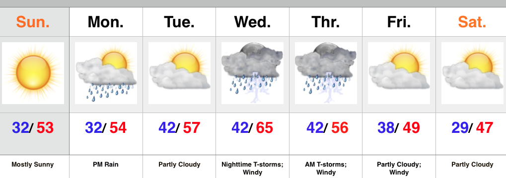
- Beautiful Sunday
- Rain arrives Monday afternoon/ evening
- Stormy Wednesday night-Thursday morning
- Much colder late next week
High pressure will supply a beauty of a second half of the weekend. After the frosty start to the day, we’ll “warm” into the lower 50s this afternoon. It’ll be a perfect crisp November day.
Changes arrive Monday as clouds increase and give way to rain as early as the afternoon as moisture rides north out of the Deep South. A wave of low pressure will ride up the western slopes of the western Appalachians and enhance early week rain to our east.
The next big ticket item is the storm that will arrive Wednesday night. We continue to keep a very close eye on this as a severe weather outbreak appears likely. Specifics still have to be ironed out and we go through the next couple days, but keep abreast of the latest weather information during the Wednesday night-Thursday morning time period.
MUCH colder air will pour into the region behind the big low as it wraps up over the Great Lakes. A hard freeze appears likely come Saturday morning.
Upcoming 7-Day Rainfall Forecast: 0.50″ – 1″
Permanent link to this article: https://indywx.com/changes-on-the-horizon/
 Highlights:
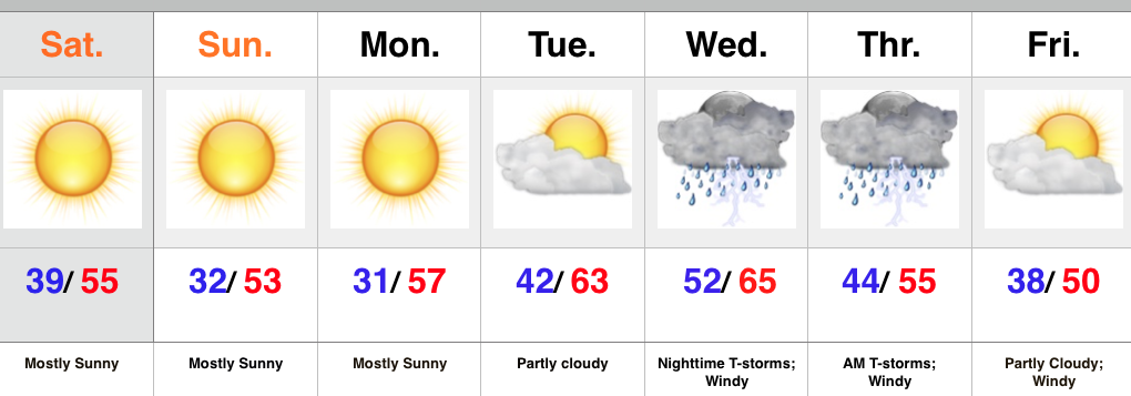
- Sunny and cool
- Midweek Storms
- Prolonged period of windy weather late week
High pressure is building into the Ohio Valley this weekend and helping supply sunshine and that cool, crisp air we enjoy this time of year. Freeze and frost conditions are ahead tonight and again Monday morning as high pressure moves overhead and results in clear skies and calm winds.
As the high moves to our east, a return SW flow will help moderate temperatures for mid week. As our next storm system comes out of the Plains it’ll intensify as it tracks into the Great Lakes. Thunderstorms will accompany the cold front as it swings through the state Wednesday night. We’ll monitor for strong to severe storm potential. A lot will hinge upon the precise track of the surface low and we’ll keep a close eye on things over the next couple days. We’ll turn cooler again late next week with strong winds shifting from the SW to NW.
Upcoming 7-Day Rainfall Forecast: 0.50″
Permanent link to this article: https://indywx.com/dry-chilly-november-weekend-mid-week-storms/
You must be logged in to view this content. Click Here to become a member of IndyWX.com for full access. Already a member of IndyWx.com All-Access? Log-in here.
Permanent link to this article: https://indywx.com/video-update-chilly-weekend-severe-potential-next-week/
As promised, we wanted to provide some thoughts around the updated sea surface temperature constructed analog model that was released this morning. In short, there aren’t many huge differences from…
You must be logged in to view this content. Click Here to become a member of IndyWX.com for full access. Already a member of IndyWx.com All-Access? Log-in here.
Permanent link to this article: https://indywx.com/updated-sst-ca-model-is-in-the-house/

