Video Update: Monday Morning Thoughts On A Busy Week Ahead…
You must be logged in to view this content. Click Here to become a member of IndyWX.com for full access. Already a member of IndyWx.com All-Access? Log-in here.
You must be logged in to view this content. Click Here to become a member of IndyWX.com for full access. Already a member of IndyWx.com All-Access? Log-in here.
 Highlights:
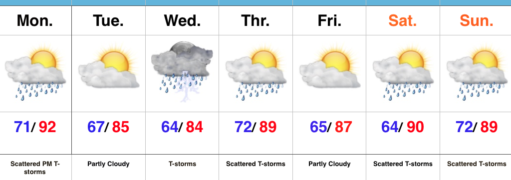
Busy Week Ahead…The overall pattern features the mean ridge position across the Four Corners region and sets up an active NW flow for our part of the country. It’s a pattern we need to get used to as it’ll remain intact to close the month and open July. Challenges are present in regards to specifics with timing and track of thunderstorm complexes we’ll deal with this week, particularly Wednesday.
In the shorter term, a frontal boundary will slip into central IN Monday night and a broken band of thunderstorms will accompany it. A few storms could reach strong to severe levels Monday evening.
Attention will then shift to Wednesday. Ingredients are coming together to present both a severe component (damaging wind the biggest threat) and localized flash flood threat. We’ll update our latest thinking Monday morning.
As we progress into late week, additional shower and thunderstorm complexes are possible, but we stress timing issues abound. It’ll be a warm and humid end to the week.
Upcoming 7-Day Precipitation Forecast:
 Highlights:
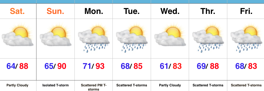
Put On That Sunscreen…High pressure will supply a beautiful open to the weekend, including mostly sunny to partly cloudy skies, low humidity levels, and warm temperatures.
Our airflow will shift to the SW Sunday and help push a more humid air mass back into the state as the day progresses. An isolated thunderstorm could accompany the return of the humid air, but for now we’ll maintain a mostly dry forecast.
Better thunderstorm chances arrive Monday evening into Tuesday as a cold front pushes in from the north. A locally strong to severe storm is possible. As we move forward into the middle and latter parts of next week, models suggest a rather unsettled time of things.
Upcoming 7-Day Precipitation Forecast:
You must be logged in to view this content. Click Here to become a member of IndyWX.com for full access. Already a member of IndyWx.com All-Access? Log-in here.
Do we rid the morning convection and cloudiness to allow strong to severe thunderstorms to develop this afternoon and evening? This morning’s video has more.
You must be logged in to view this content. Click Here to become a member of IndyWX.com for full access. Already a member of IndyWx.com All-Access? Log-in here.