
You must be logged in to view this content. Click Here to become a member of IndyWX.com for full access. Already a member of IndyWx.com All-Access? Log-in here.
Permanent link to this article: https://indywx.com/snowy-valentines-day-on-the-way/
Feb 12
Bitterly Cold; Accumulating Sunday Snow…
 Highlights:
- Bitterly cold
- Light accumulating snow Sunday
- Active pattern continues, but with questions
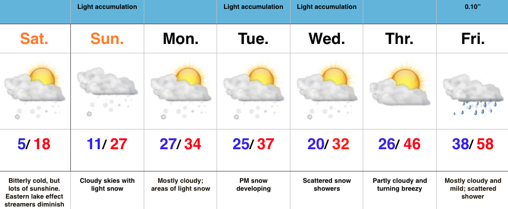
Bitterly Cold; Accumulating Sunday Snow…We label the cold that we’ll deal with Saturday “hurt your face” cold. It’ll be a bitter day with lows in the lower-mid single digits (even some areas below zero), a biting NW wind, and AM lake-generated snow streamers across eastern portions of the state. Bundle up, friends!
We still track accumulating snow for Valentine’s Day. Clouds will lower and thicken Sunday morning and snow should overspread the area as we progress into the late morning hours. The potential of a plowable snow still looks good from this distance, and we’ll have our initial snowfall map out later Saturday (want to get a look at the full 00z suite before issuing).
Right on the heels of Sunday’s snow maker will be another disturbance Tuesday. Modeling differs on the track (surprise, surprise ;-)), but the potential is there for additional accumulating snows Tuesday into Wednesday. Stay tuned.
After a final disturbance Wednesday (with light snow potential), we’ll see a marked wind shift to the south to close the week, followed by a brief, but impressive, surge of milder air.
Permanent link to this article: https://indywx.com/bitterly-cold-accumulating-sunday-snow/
Feb 11
Taking A Moment To Level Set…
Two snow events are lined up to impact at least parts of central IN over the next few days. Friday Light Snow: We still expect an area of light snow…
You must be logged in to view this content. Click Here to become a member of IndyWX.com for full access. Already a member of IndyWx.com All-Access? Log-in here.
Permanent link to this article: https://indywx.com/taking-a-moment-to-level-set/
Feb 10
Very Cold; Eyes On Sunday-Monday…
 Highlights:
- Scattered snow showers continue
- Reinforcing arctic air arrives Friday-Saturday
- Winter storm brewing for some Sunday-Monday
- Moderating temperatures next week
Very Cold; Eyes On Sunday-Monday…We’ve been dealing with snow showers for over 48 hours. As expected, accumulations haven’t been uniform, but range, on average, from 1″ to 3″ across central IN. Morning snow showers continue before drier air will invade from the west and shut the snow production off this afternoon.
Tomorrow will be a dry, cold day before arctic reinforcements arrive Friday into Saturday. Snow showers will accompany the arctic express to close the work week.
Saturday looks brutal. Very cold and windy with below zero wind chills most of the day.
Focus continues on Sunday and Monday and we forecast snow to overspread the area late Sunday night, continuing into Monday. It’s still early, but this may be a “more important” event, locally. This will actually come on the “tail end” of the arctic air mass that will have engulfed the region over a week by that point. We think next week is much milder before we reload the cold to close February and head into March.
Permanent link to this article: https://indywx.com/very-cold-eyes-on-sunday-monday/
Feb 09
Tuesday Morning Rambles…
5-10 day temperature anomalies. SOURCE: Tropicaltidbits.com Week 2 Accumulated Precipitation Anomalies. SOURCE: Tropicaltidbits.com Interested in our personalized consulting services? Email bill@indywx.com for more details. We’re just beginning a very wintry…
You must be logged in to view this content. Click Here to become a member of IndyWX.com for full access. Already a member of IndyWx.com All-Access? Log-in here.
Permanent link to this article: https://indywx.com/tuesday-morning-rambles-2/
