VIDEO: Touching base on Tuesday evening…
You must be logged in to view this content. Click Here to become a member of IndyWX.com for full access. Already a member of IndyWx.com All-Access? Log-in here.
You must be logged in to view this content. Click Here to become a member of IndyWX.com for full access. Already a member of IndyWx.com All-Access? Log-in here.
 The 2016-2017 IndyWx.com Winter Outlook is now available.
Highlights:
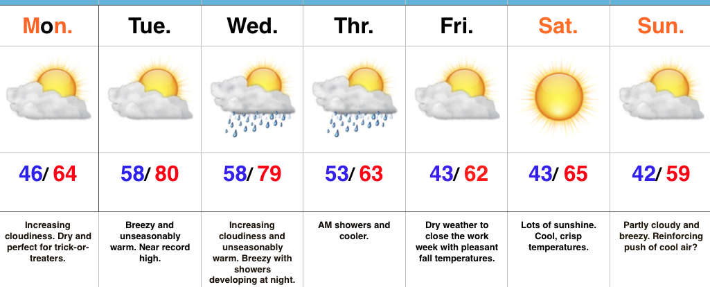
Pleasant Halloween Weather…Recent Halloweens have produced accumulating snow, heavy rain, and storms. Thankfully, today will be much more pleasant and feature mostly cloudy skies and pleasant temperatures.
Speaking of temperatures, they’ll get a big boost Tuesday and Wednesday (both days will feature near record highs). A breezy SW wind will be in play and clouds will increase Wednesday, eventually giving way to showers Wednesday night. Rain will continue Thursday morning as a cold front moves through the region. Cooler, drier air will move in as we close the work week.
Looking ahead to the weekend, Saturday will be dry and pleasant. Sunday is a bit of a question mark. The European model is suggesting a reinforcing push of cooler air will ooze into the area, while the GFS is less impressed. We’ll lean our forecast more towards the European for now. Regardless, Sunday will be a dry day.
Upcoming 7-Day Precipitation Forecast:
Author: Bill McMillan- Founder and Owner of IndyWx.com
Date: Sunday, October 30th, 2016
2016-2017 IndyWx.com Winter Outlook
We’re bullish on a colder and snowier than normal winter across central IN (and a widespread portion of the Mid West and Ohio Valley, for that matter) for 2016-2017. Furthermore, model data and analogs suggest the period Thanksgiving to Christmas could be quite wintry this year. If you’re one of those that likes it cold with storms and rumors of storms through the holiday season, this could be your year.
The basis of the IndyWx.com 2016-2017 Winter Outlook
The PDO (read more about the Pacific Decadal Oscillation here) is a bit of a wildcard moving forward. The past (2) years has featured a positive PDO, but latest data shows that we’ve slipped into a slightly negative state (-1.06 in Sept). Negative phases favor warmth, locally. Interestingly, most model data suggests a positive look this winter.
The image below shows the differences in what a warm (left) and cool (right) PDO looks like.
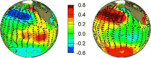 (Image courtesy of JISAO)
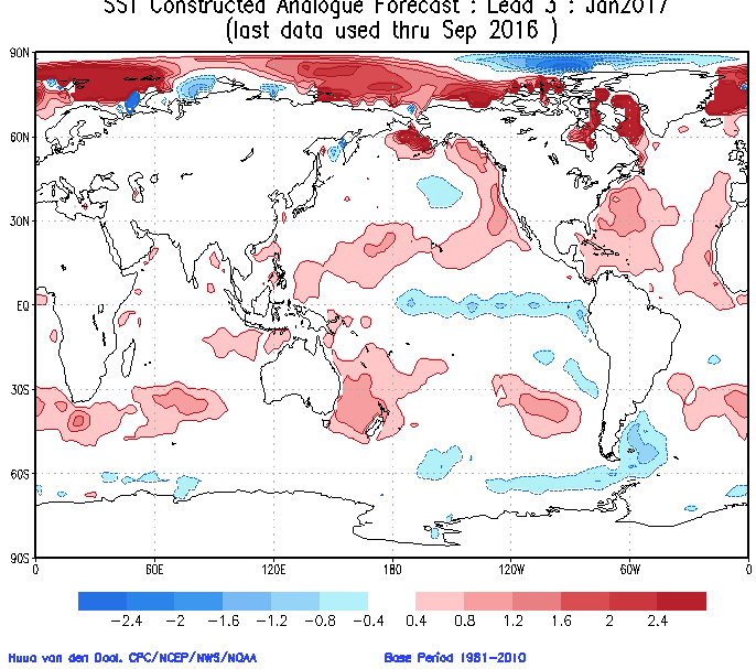
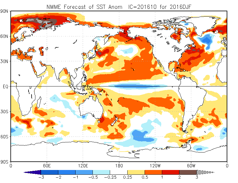
Sea surface temperature model data centered on the upcoming winter
SST CA model
 NMME model
 JAMSTEC model
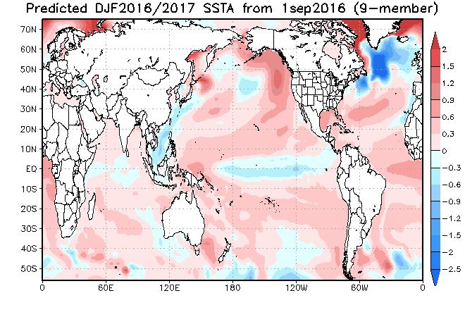 JMA model
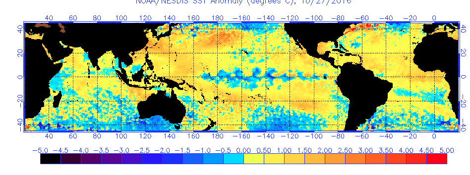
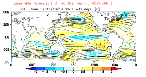 We’ve done an “about face” in the equatorial Pacific. Last year at this time featured one of the strongest El Ninos on record. (Remember that ridiculously warm December last year)?! This year, a snap shot of the SST anomalies (from 10.27.16) shows a vastly different look and the weak La Nina underway. We think a weak La Nina dominates the majority of the upcoming meteorological winter.
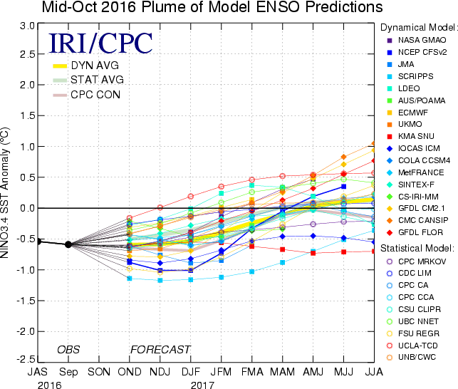
 The International Research Institute for Climate and Society (IRI) plume shows the weak La Nina continuing through winter before rebounding over the spring.
 Analogs:
We’re keying in on the following years to get an idea of what the future may hold for meteorological winter (December-February), based on the ENSO state and QBO west.
We expect a southeast ridge to be a big player through the balance of the upcoming winter. While that will likely keep our friends in the southeast region milder and drier when compared to normal, it’ll also serve as enough resistance to keep us on our toes with an active storm track through the Ohio Valley. We’ve alluded to this since late summer and early fall, but the idea of a “big hitter” winter is very much on the table and could include a couple significant winter storms through our part of the country. Additionally, a second storm track from northwest-flow clippers will have to be monitored- particularly mid and late winter.
Despite a warm fall, we expect the evolution of the pattern to undergo a significant shift mid-November and again want to reiterate the holiday stretch could be quite “fun” this year- in stark contrast to the 2015 Christmas season.
IndyWx.com 2016-2017 Winter Forecast
 Highlights:
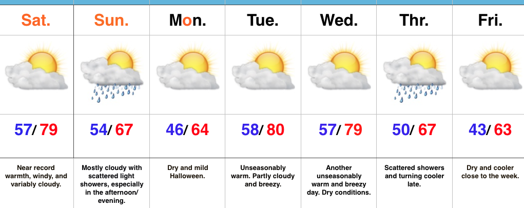
Hard To Believe This Is Late October…A strong southwest flow will help provide a windy, but incredibly warm Saturday. Highs will approach record territory around 80. (We’ll have to keep an eye on that 81 degree record set in 1922). Southwest winds gusting around 30 MPH will be a good bet this afternoon, especially in the open country.
A weak disturbance will push southeast Sunday and help to increase our cloud cover, along with providing scattered showers- mainly in the afternoon and evening. We’ll turn cooler, but still remain above normal for Halloween. Trick-or-treat conditions look ideal, especially considering recent Halloweens have served up rain, storms, and snow across the region.
A warm front will lift north Monday night and offer up another opportunity to push for record warmth Tuesday and Wednesday before a cold front slides through Thursday with showers. Cooler air will settle into the Ohio Valley and Mid West to wrap up the work week.
Upcoming 7-Day Precipitation Forecast:
You must be logged in to view this content. Click Here to become a member of IndyWX.com for full access. Already a member of IndyWx.com All-Access? Log-in here.