This morning we’re unveiling a new “hand-crafted” 10-day forecast that will be below the Client video discussion and/ or posts each morning. Enjoy!
Today opens bright and quiet and most of our Masters Sunday will feature calm conditions, locally. The only fly in the ointment will come from a cluster of storms that will erupt across Ohio and make an attempt to back build into at least eastern portions of the state this evening. We’ll keep close eyes on trends. Otherwise, Monday will get back to a return to quiet conditions before an active stretch develops. Eventually, we’ll turn much calmer (and cooler) next weekend into early stages of the following week.
While unseasonably warm air will build in here early next week, don’t put away the cold weather gear just yet. We’re likely even looking at additional frost threats as we get towards late next weekend and/ or early Week 2. More details below in this week’s #AGwx and #Severe Weather Outlook.
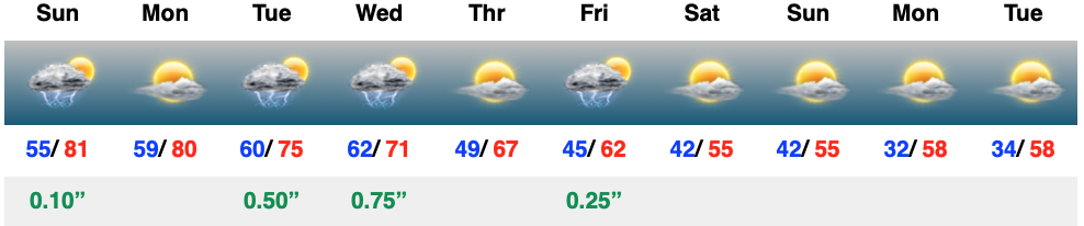
“Transitional” is the word to describe the upcoming couple weeks worth of weather around these parts. The warmth to open the period will cool significantly next weekend and early Week 2, only to give way to renewed warming late April.
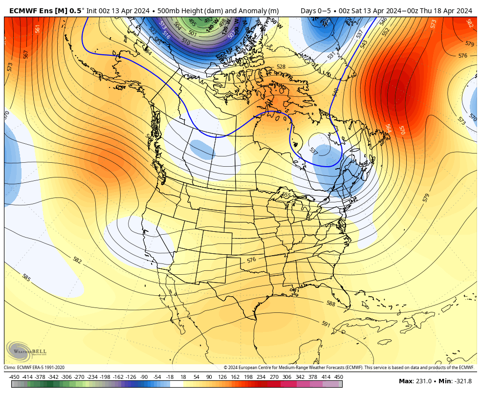
Note the roller coaster in the temperature anomalies over the next couple of weeks.
The active pattern in the week ahead will dry significantly late in the forecast period as the cooler airmass takes hold.
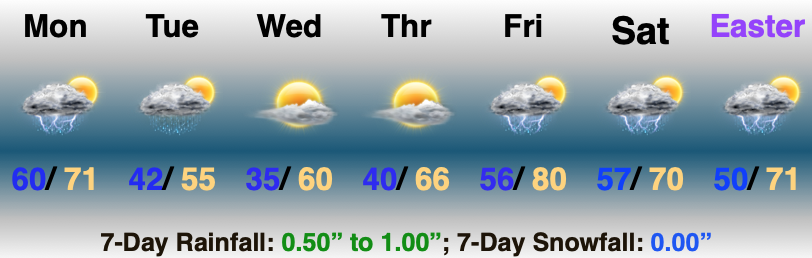
In the more immediate term, we’re tracking 2 storm systems in the week ahead: Tuesday – Wednesday and again Thursday night into Friday.
The Storm Prediction Center includes western Indiana in a risk of severe weather Tuesday. We’ll monitor for the potential of a further east extension of this risk area.
We think (2) rounds of storms are on deck Tuesday. The first round likely is associated with a warm front lifting north through the state Tuesday morning (hail threat) followed by a second round of activity Tuesday night into Wednesday morning (main concern being damaging straight line winds with this round). As of now, storm total rainfall amounts of 0.50″ to 1″ seem likely during this timeframe.
Another round of showers and embedded thunder will precede a blast of chilly air next weekend. We bracket Thursday night into Friday morning for this particular round of rain. An additional half inch, or so, of rain seems reasonable from this distance.
By the time we get to next weekend and early Week 2, drier and much cooler, more stable air should take up residence.
We note the warm open, chilly finish in the 10-day meteogram. Also note the frost threat at the end of this period.
Updated 04.12.24 @ 7:48a Today will certainly be another less than ideal weather day across central Indiana, but the trade off for what awaits Saturday will be worth it. You’ve…
You must be logged in to view this content. Click Here to become a member of IndyWX.com for full access. Already a member of IndyWx.com All-Access? Log-in here.
Updated 04.11.24 @ 7:39a Masters Thursday will be a wash-out up this way. Thankfully, down at Augusta, GA we’re talking about better weather- at least relatively speaking. Additional showers…
You must be logged in to view this content. Click Here to become a member of IndyWX.com for full access. Already a member of IndyWx.com All-Access? Log-in here.
Updated 04.10.24 @ 7:40a We’re only dealing with a few light showers out the door this morning, but a heavier and more widespread area of rain will develop through the…
You must be logged in to view this content. Click Here to become a member of IndyWX.com for full access. Already a member of IndyWx.com All-Access? Log-in here.
Permanent link to this article: https://indywx.com/video-heavy-rain-develops-later-today-into-thursday-keeping-an-eye-on-the-potential-of-strong-storms-early-next-week/


 Additional showers…